Fichier:View of stream along scenic Route 101 in Northern California LCCN2013632305.tif

Taille de cet aperçu JPG pour ce fichier TIF : 800 × 534 pixels. Autres résolutions : 320 × 214 pixels | 640 × 427 pixels | 1 024 × 683 pixels | 1 280 × 854 pixels | 2 560 × 1 709 pixels | 7 360 × 4 912 pixels.
Fichier d’origine (7 360 × 4 912 pixels, taille du fichier : 206,9 Mio, type MIME : image/tiff)
Ce fichier et sa description proviennent de Wikimedia Commons.
Description
| Description |
English: Title: View of stream along scenic Route 101 in Northern California
Physical description: 1 photograph : digital, tiff file, color. Notes: Title, date, and keywords provided by the photographer.; Credit line: The Jon B. Lovelace Collection of California Photographs in Carol M. Highsmith's America Project, Library of Congress, Prints and Photographs Division.; Gift; The Capital Group Companies Charitable Foundation in memory of Jon B. Lovelace; 2012; (DLC/PP-2012:063).; Forms part of: Jon B. Lovelace Collection of California Photographs in Carol M. Highsmith's America Project in the Carol M. Highsmith Archive. |
||||||||||||||||||||||||||
| Date | |||||||||||||||||||||||||||
| Source |
Library of Congress
|
||||||||||||||||||||||||||
| Auteur |
|
||||||||||||||||||||||||||
| Autorisation (Réutilisation de ce fichier) |
No known restrictions on publication.
|
||||||||||||||||||||||||||


| Lieu de la prise de vue | | Voir cet endroit et d’autres images sur : OpenStreetMap |
|---|
Conditions d’utilisation
| Cette œuvre est issue de la Carol M. Highsmith Archive collection de la Bibliothèque du Congrès. Selon la bibliothèque, il n'existe aucune restriction connue en matière de droits d'auteur pour l'utilisation de cette œuvre. Carol M. Highsmith has stipulated that her photographs are in the public domain. Photographs of sculpture or other works of art may be restricted by the copyright of the artist. |
 |
Historique du fichier
Cliquer sur une date et heure pour voir le fichier tel qu'il était à ce moment-là.
| Date et heure | Vignette | Dimensions | Utilisateur | Commentaire | |
|---|---|---|---|---|---|
| actuel | 3 septembre 2016 à 04:37 | 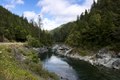 | 7 360 × 4 912 (206,9 Mio) | Fæ | LOC 2013632305, Carol M. Highsmith collection. P738.8278 TIFF (206.9mb) |
Utilisation du fichier
La page suivante utilise ce fichier :
Usage global du fichier
Les autres wikis suivants utilisent ce fichier :
- Utilisation sur en.wikipedia.org