Fichier:USACE Fort Thompson Big Bend Dam.jpg

Taille de cet aperçu : 800 × 534 pixels. Autres résolutions : 320 × 214 pixels | 640 × 427 pixels | 1 024 × 683 pixels | 1 500 × 1 001 pixels.
Fichier d’origine (1 500 × 1 001 pixels, taille du fichier : 599 kio, type MIME : image/jpeg)
Ce fichier et sa description proviennent de Wikimedia Commons.
| Description |
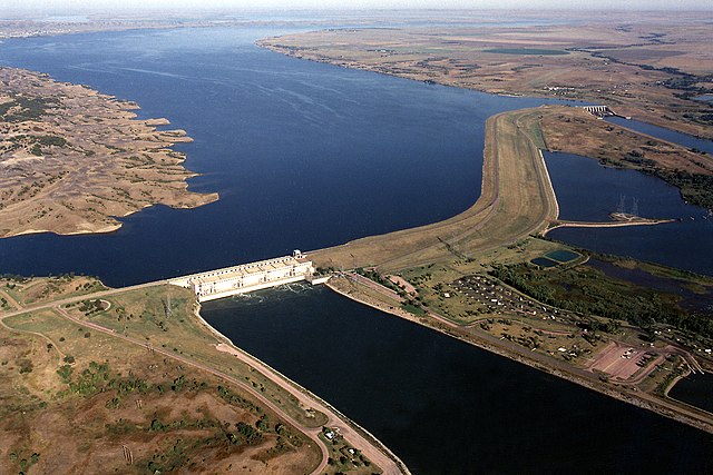
English: Big Bend Dam on the Missouri River, South Dakota. View is upriver to the west-northwest. The dam is located near Fort Thompson, South Dakota, USA. |
|||
| Date | ||||
| Source |
U.S. Army Corps of Engineers Digital Visual Library Image page Image description page Digital Visual Library home page |
|||
| Auteur | Harry Weddington, U.S. Army Corps of Engineers | |||
| Autorisation (Réutilisation de ce fichier) |
|
| Lieu de la prise de vue | | Voir cet endroit et d’autres images sur : OpenStreetMap |
|---|
Historique du fichier
Cliquer sur une date et heure pour voir le fichier tel qu'il était à ce moment-là.
| Date et heure | Vignette | Dimensions | Utilisateur | Commentaire | |
|---|---|---|---|---|---|
| actuel | 2 avril 2007 à 00:02 | | 1 500 × 1 001 (599 kio) | DanMS | {{Information | Description = {{en|Big Bend Dam on the Missouri River, South Dakota. View is upriver to the west-northwest. The dam is located near Fort Thompson, South Dakota, USA.}} | Source = U.S. Army Corps of Engineers Digital Visual Libra |
Utilisation du fichier
Les 5 pages suivantes utilisent ce fichier :
Usage global du fichier
Les autres wikis suivants utilisent ce fichier :
- Utilisation sur ar.wikipedia.org
- Utilisation sur ceb.wikipedia.org
- Utilisation sur ce.wikipedia.org
- Utilisation sur cy.wikipedia.org
- Utilisation sur de.wikipedia.org
- Utilisation sur en.wikipedia.org
- Utilisation sur es.wikipedia.org
- Utilisation sur ga.wikipedia.org
- Utilisation sur hu.wikipedia.org
- Utilisation sur hy.wikipedia.org
- Utilisation sur ko.wikipedia.org
- Utilisation sur no.wikipedia.org
- Utilisation sur pl.wikipedia.org
- Utilisation sur pl.wikiquote.org
- Utilisation sur pl.wiktionary.org
- Utilisation sur pt.wikipedia.org
- Utilisation sur ro.wikipedia.org
- Utilisation sur ru.wikipedia.org
- Utilisation sur simple.wikipedia.org
- Utilisation sur sr.wikipedia.org
- Utilisation sur tr.wikipedia.org
- Utilisation sur tt.wikipedia.org
- Utilisation sur uk.wikipedia.org
- Utilisation sur ur.wikipedia.org
- Utilisation sur www.wikidata.org