Fichier:The Old Chapel, Creslow - geograph.org.uk - 234817.jpg
Pas de plus haute résolution disponible.
The_Old_Chapel,_Creslow_-_geograph.org.uk_-_234817.jpg (640 × 480 pixels, taille du fichier : 81 kio, type MIME : image/jpeg)
Ce fichier et sa description proviennent de Wikimedia Commons.
Description
| Description |
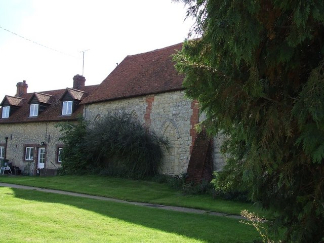
English: The Old Chapel, Creslow. This chapel is marked on the map and edged in black suggesting it is a public building, but it looks to me as though it has been incorporated into the adjoining building. The only signs were ones informing that there was no right of way for the public - so at best it probably has a very small congregation !
Edit: According to the English Heritage Viewfinder website "The former parish church, which ceased being used in the 18th century, was first a dovecot and is now used as an outbuilding of the Manor House. " ( See http://viewfinder.english-heritage.org.uk/search/reference.asp?index=385&imageUID=51561&main_query=&theme=&period=&county=&district=&place_name=Ham ) However the BHO website (see http://www.british-history.ac.uk/report.aspx?compid=42572&strquery=Parish%20Creslow#s3 ) itself quoting the "History of the County of Buckingham" suggests that it had not been used as a church since the time of Elizabeth I (1558-1603). A list of the rectors (see http://met.open.ac.uk/genuki/big/eng/BKM/Creslow/rectors.html ) finishes with the appointment of Thomas Davis A.M. in 1554 - which serves to confirm this earlier date.
|
|
| Date | ||
| Source | From geograph.org.uk | |
| Auteur | Rob Farrow | |
| Attribution (imposé par la licence) | Rob Farrow / The Old Chapel, Creslow / | |
| Position de l'objet | | Voir cet endroit et d’autres images sur : OpenStreetMap |
|---|
_heading:135.00&language=fr)
Conditions d’utilisation

|
Cette image provient de la collection du projet Geograph British Isles. Pour obtenir les coordonnées du photographe, veuillez consulter cette page de description de l'image sur le site du projet. Les droits d'auteurs sur cette image sont détenus par Rob Farrow ; l'image est placée sous une licence Creative Commons avec mention de paternité et partage à l'identique (CC-By-SA) en version 2.0.
|
Ce fichier est disponible selon les termes de la licence Creative Commons Attribution – Partage dans les Mêmes Conditions 2.0 Générique
Attribution: Rob Farrow
- Vous êtes libre :
- de partager – de copier, distribuer et transmettre cette œuvre
- d’adapter – de modifier cette œuvre
- Sous les conditions suivantes :
- paternité – Vous devez donner les informations appropriées concernant l'auteur, fournir un lien vers la licence et indiquer si des modifications ont été faites. Vous pouvez faire cela par tout moyen raisonnable, mais en aucune façon suggérant que l’auteur vous soutient ou approuve l’utilisation que vous en faites.
- partage à l’identique – Si vous modifiez, transformez, ou vous basez sur cette œuvre, vous devez distribuer votre contribution sous la même licence ou une licence compatible avec celle de l’original.
Historique du fichier
Cliquer sur une date et heure pour voir le fichier tel qu'il était à ce moment-là.
| Date et heure | Vignette | Dimensions | Utilisateur | Commentaire | |
|---|---|---|---|---|---|
| actuel | 1 février 2010 à 04:29 | | 640 × 480 (81 kio) | GeographBot | == {{int:filedesc}} == {{Information |description={{en|1=The Old Chapel, Creslow. This chapel is marked on the map and edged in black suggesting it is a public building, but it looks to me as though it has been incorporated into the adjoining building. Th |
Utilisation du fichier
La page suivante utilise ce fichier :
Usage global du fichier
Les autres wikis suivants utilisent ce fichier :
- Utilisation sur ar.wikipedia.org
- Utilisation sur arz.wikipedia.org
- Utilisation sur ceb.wikipedia.org
- Utilisation sur cy.wikipedia.org
- Utilisation sur en.wikipedia.org
- Utilisation sur lld.wikipedia.org
- Utilisation sur nl.wikipedia.org
- Utilisation sur pl.wikipedia.org
- Utilisation sur sv.wikipedia.org
- Utilisation sur www.wikidata.org