Fichier:Ship Tracks off the California Coast - NASA Earth Observatory.jpg
Ship_Tracks_off_the_California_Coast_-_NASA_Earth_Observatory.jpg (720 × 540 pixels, taille du fichier : 184 kio, type MIME : image/jpeg)
Ce fichier et sa description proviennent de Wikimedia Commons.
Description
| Description |
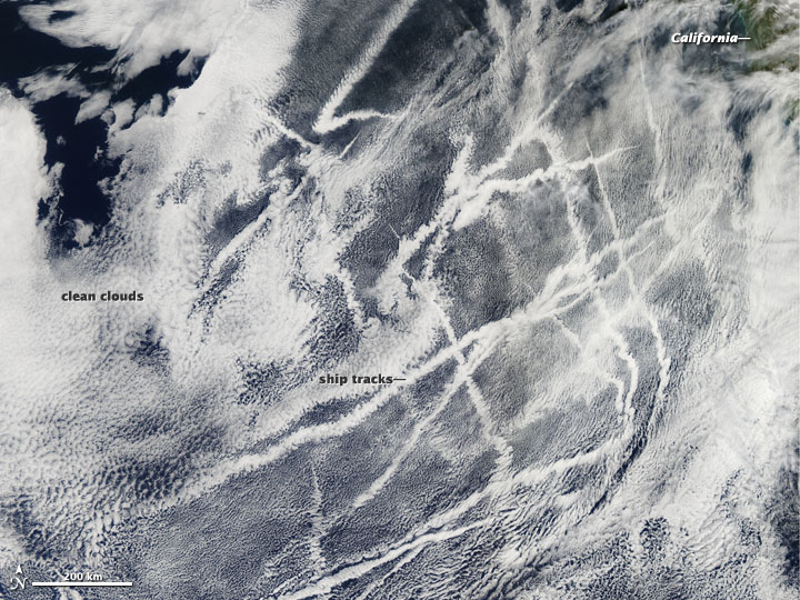
To download the full resolution and other files go to: earthobservatory.nasa.gov/IOTD/view.php?id=77345&src=... Ships churning across the Pacific Ocean left this cluster of bright cloud trails lingering in the atmosphere late last month. The narrow clouds, known as ship tracks, form when water vapor condenses around tiny particles of pollution that ships either emit directly as exhaust or that form as a result of gases within the exhaust. The Moderate Resolution Imaging Spectroradiometer (MODIS) aboard the Aqua satellite captured this natural-color image on February 21, 2012. The criss-crossing clouds off the coast of California stretch many hundreds of kilometers from end to end. The narrow ends of the clouds are youngest, while the broader, wavier ends are older. Some of the pollution particles generated by ships (especially sulfates) are soluble in water and can serve as the seeds around which cloud droplets form. Clouds infused with ship exhaust have more and smaller droplets than unpolluted clouds. As a result, light hitting the ship tracks scatters in many directions, making them appear brighter than other types of marine clouds, which are usually seeded by larger, naturally occurring particles such as sea salt. (In this image, the ship tracks don’t appear particularly bright because the surrounding clouds are also fairly bright. But in this March 2009 image and this July 2010 image the brightening effect of the pollution is quite clear.) The enhanced reflectivity of ship tracks means they shade Earth’s surface from incoming sunlight, which produces a local cooling effect. However, determining whether ship emissions have a broader climate effect is complex because ships also emit pollutants that have a warming influence, such as carbon dioxide and black carbon. Research is ongoing, but one recent satellite study found that ship emissions do not cause changes on a large enough scale to affect climate significantly. At the same time, researchers have shown that the ship emissions pose a clear hazard to human health. Seventy percent of all ship tracks occur within 500 kilometers of the coast, which means shipping exposes large numbers of people in coastal cites to high levels of health-sapping particulates. One study concluded, for example, that shipping-related particulate matter is responsible for 60,000 premature deaths each year, about 5 percent of the total premature deaths associated with particulate air pollution each year. NASA images courtesy Jeff Schmaltz, LANCE/EOSDIS MODIS Rapid Response Team at NASA GSFC. Caption by Adam Voiland. The Earth Observatory's mission is to share with the public the images, stories, and discoveries about climate and the environment that emerge from NASA research, including its satellite missions, in-the-field research, and climate models. Like us on Facebook Follow us on Twitter Add us to your circles on Google+ |
| Date | |
| Source | Ship Tracks off the California Coast |
| Auteur | NASA's Earth Observatory |
| Lieu de la prise de vue | | Voir cet endroit et d’autres images sur : OpenStreetMap |
|---|
Conditions d’utilisation
- Vous êtes libre :
- de partager – de copier, distribuer et transmettre cette œuvre
- d’adapter – de modifier cette œuvre
- Sous les conditions suivantes :
- paternité – Vous devez donner les informations appropriées concernant l'auteur, fournir un lien vers la licence et indiquer si des modifications ont été faites. Vous pouvez faire cela par tout moyen raisonnable, mais en aucune façon suggérant que l’auteur vous soutient ou approuve l’utilisation que vous en faites.
| Cette image a été originellement postée sur Flickr par NASA Earth Observatory à l'adresse https://www.flickr.com/photos/68824346@N02/6818503264. Elle a été passée en revue le 2 juillet 2012 par le robot FlickreviewR, qui a confirmé qu'elle se trouvait sous licence cc-by-2.0. |
Historique du fichier
Cliquer sur une date et heure pour voir le fichier tel qu'il était à ce moment-là.
| Date et heure | Vignette | Dimensions | Utilisateur | Commentaire | |
|---|---|---|---|---|---|
| actuel | 2 juillet 2012 à 19:08 | | 720 × 540 (184 kio) | Dzlinker | == {{int:filedesc}} == {{Information |Description=To download the full resolution and other files go to: [http://earthobservatory.nasa.gov/IOTD/view.php?id=77345&src=flickr earthobservatory.nasa.gov/IOTD/view.php?id=77345&src=...] Ships churning acros... |
Utilisation du fichier
La page suivante utilise ce fichier :