Fichier:Satellite image of Denmark in July 2001.jpg

Taille de cet aperçu : 800 × 596 pixels. Autres résolutions : 320 × 239 pixels | 640 × 477 pixels | 1 024 × 763 pixels | 1 280 × 954 pixels | 1 905 × 1 420 pixels.
Fichier d’origine (1 905 × 1 420 pixels, taille du fichier : 190 kio, type MIME : image/jpeg)
Ce fichier et sa description proviennent de Wikimedia Commons.
| Ce fichier provient de la NASA. Sauf exception, les documents créés par la NASA ne sont pas soumis à copyright. Pour plus d'informations, voir la politique de copyright de la NASA. | ||
 |
Attention :
|
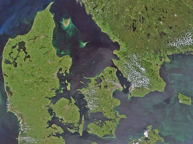
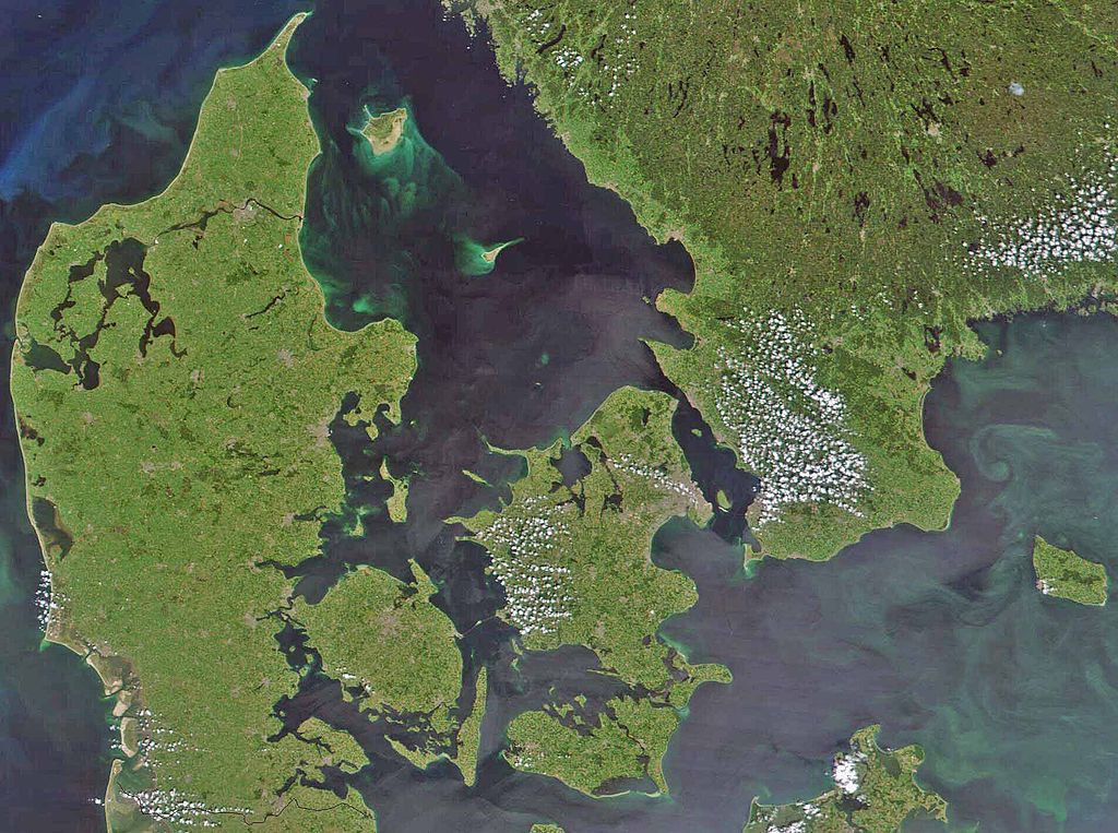
Satellite image of Denmark in July 2001. Cropped image, original taken from NASA's Visible Earth http://visibleearth.nasa.gov/view_rec.php?id=1909
- Interestingly, the Danish-German border is incorrectly placed. The line shown on the map has the correct shape, but is located c. 10 kilometres south of the current border. The line should have been positioned between the islands Rømø and Sylt in the west, and through the fjord to the east. Valentinian (talk) 17:09, 12 November 2006 (UTC)
Historique du fichier
Cliquer sur une date et heure pour voir le fichier tel qu'il était à ce moment-là.
| Date et heure | Vignette | Dimensions | Utilisateur | Commentaire | |
|---|---|---|---|---|---|
| actuel | 24 février 2008 à 10:39 | | 1 905 × 1 420 (190 kio) | XcepticZP | Color correction, ligthened up. Smaller file size due to better jpg compression. |
| 10 avril 2005 à 16:22 |  | 1 905 × 1 420 (369 kio) | Hautala | {{PD-USGov-NASA}} Satellite image of Denmark in July 2001. Cropped image, original taken from NASA's Visible Earth http://visibleearth.nasa.gov/view_rec.php?id=1909 |
Utilisation du fichier
La page suivante utilise ce fichier :
Usage global du fichier
Les autres wikis suivants utilisent ce fichier :
- Utilisation sur af.wikipedia.org
- Utilisation sur arz.wikipedia.org
- Utilisation sur az.wikipedia.org
- Utilisation sur be.wikipedia.org
- Utilisation sur bn.wikipedia.org
- Utilisation sur ca.wikipedia.org
- Utilisation sur ceb.wikipedia.org
- Utilisation sur ce.wikipedia.org
- Utilisation sur cs.wikipedia.org
- Utilisation sur da.wikipedia.org
- Diskussion:København
- Diskussion:Odense
- Diskussion:Hjørring
- Diskussion:Faaborg
- Diskussion:Barneholm
- Svæveflyveklubber i Danmark
- Diskussion:Frederiksberg
- Diskussion:Ærøskøbing
- Diskussion:Frederikssund
- Diskussion:Kalundborg
- Diskussion:Nykøbing Falster
- Skabelon:Klik
- Diskussion:Nivå
- Bruger:Sir48/Sandkasse
- Diskussion:Frederiksværk
- Diskussion:Djævleø
- Diskussion:Frederikshavn
- Diskussion:Lillerød
- Diskussion:Helsingør
- Diskussion:Hørsholm
- Diskussion:Roskilde
- Diskussion:Visborg (by)
- Diskussion:Rønne
- Diskussion:Svendborg
- Diskussion:Slagelse
- Portal:Danmark
- Portal:Danmark/Introtekst
- Diskussion:Næstved
- Diskussion:Fugleholm
- Diskussion:Nexø
- Diskussion:Nakskov
- Diskussion:Allinge-Sandvig
- Diskussion:Sorø
- Diskussion:Rudkøbing
- Diskussion:Lysbro (Silkeborg)
- Skabelondiskussion:Kortpositioner/doc
- Diskussion:Holbæk
- Diskussion:Halsted
Voir davantage sur l’utilisation globale de ce fichier.