Fichier:Santa Monica Bay Map.jpg
Pas de plus haute résolution disponible.
Santa_Monica_Bay_Map.jpg (468 × 597 pixels, taille du fichier : 283 kio, type MIME : image/jpeg)
Ce fichier et sa description proviennent de Wikimedia Commons.
Description
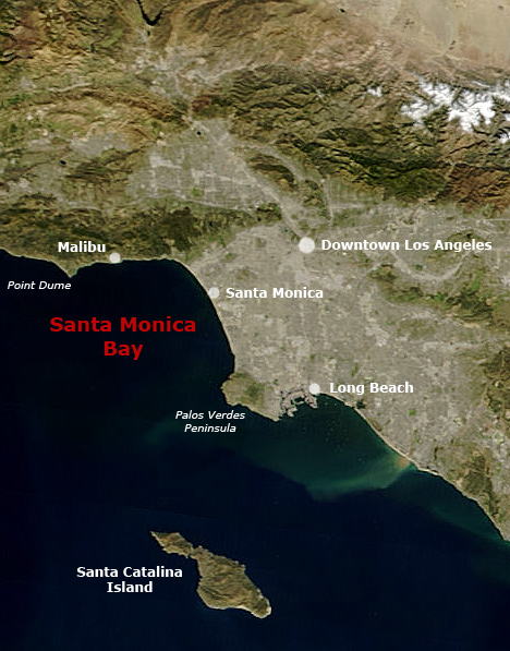
English: Satellite pictures of Southern California with Santa Monica Bay and Greater Los Angeles.
- Following the original text out of the English wikipedia, where it was originally uploaded:
- Map of Southern California with Santa Monica Bay identified
- Underlying map is an aerial map obtained from NASA (original:
- The labeling is by en:User:Mikeetc
Conditions d’utilisation
| Ce fichier provient de la NASA. Sauf exception, les documents créés par la NASA ne sont pas soumis à copyright. Pour plus d'informations, voir la politique de copyright de la NASA. | ||
 |
Attention :
|
Historique du fichier
Cliquer sur une date et heure pour voir le fichier tel qu'il était à ce moment-là.
| Date et heure | Vignette | Dimensions | Utilisateur | Commentaire | |
|---|---|---|---|---|---|
| actuel | 29 mai 2006 à 01:55 | | 468 × 597 (283 kio) | Otto Normalverbraucher | following the original text out of the english wikipedia, where it was originally uploaded: ''Map of Southern California with Santa Monica Bay identified Underlying map is an aerial map obtained from NASA (original: http://earthobservatory.nasa.gov/Natu |
Utilisation du fichier
La page suivante utilise ce fichier :
Usage global du fichier
Les autres wikis suivants utilisent ce fichier :
- Utilisation sur ar.wikipedia.org
- Utilisation sur ceb.wikipedia.org
- Utilisation sur ckb.wikipedia.org
- Utilisation sur de.wikipedia.org
- Utilisation sur en.wikipedia.org
- Utilisation sur es.wikipedia.org
- Utilisation sur fr.wikibooks.org
- Utilisation sur he.wikipedia.org
- Utilisation sur pl.wikipedia.org
- Utilisation sur pt.wikipedia.org
- Utilisation sur ro.wikipedia.org
- Utilisation sur ru.wikipedia.org
- Utilisation sur www.wikidata.org