Fichier d’origine(796 × 858 pixels, taille du fichier : 161 kio, type MIME : image/jpeg)

Ce fichier et sa description proviennent de Wikimedia Commons.

Description

Description
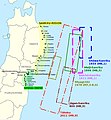
English: Historical tsunamis in the Sanriku area and selection of areas affected by the 2011 Tōhoku tsunami. (Source: Anawat Suppasri, Nobuo Shuto, Fumihiko Imamura, Shunichi Koshimura, Erick Mas, Ahmet Cevdet Yalciner: "Lessons Learned from the 2011 Great East Japan Tsunami: Performance of Tsunami Countermeasures, Coastal Buildings, and Tsunami Evacuation in Japan", Pure and Applied Geophysics, 170, (6-8), 2013, p. 993–1018, here p. 994, figure 1, DOI=10.1007/s00024-012-0511-7, online published: 7. July 2012. Modified and combined with: Nobuhito Mori, Daniel T. Cox, Tomohiro Yasuda, Hajime Mase: "Overview of the 2011 Tohoku Earthquake Tsunami Damage and Its Relation to Coastal Protection along the Sanriku Coast", Earthquake Spectra, 29 (S1), 2013, pp. 127-143, DOI=10.1193/1.4000118, here p. 131, fig. 3. And combined with: Tadashi Nakasu, Yuichi Ono, Wiraporn Pothisiri: "Why did Rikuzentakata have a high death toll in the 2011 Great East Japan Earthquake and Tsunami disaster? Finding the devastating disaster’s root causes", International Journal of Disaster Risk Reduction, Band=27, March 2018, pp. 21-36, DOI: 10.1016/j.ijdrr.2017.08.001, online published on 15 August 2017, here p. 23, fig. 1. Cf. Akemi Ishigaki, Hikari Higashi, Takako Sakamoto, Shigeki Shibahara: "The Great East-Japan Earthquake and Devastating Tsunami: An Update and Lessons from the Past Great Earthquakes in Japan since 1923", The Tohoku Journal of Experimental Medicine, 229, 4, 2013, pp. 287-299, DOI:10.1620/tjem.229.287, online published on 13 April 2013, here: p. 289, Fig. 1 "Distribution of the epicenters of the three Great Earthquakes."
Deutsch: Historische Tsunamis in der Sanriku-Region und Auswahl von Gebieten, die vom Tōhoku-Tsunami von 2011 betroffen waren. (Quelle: Anawat Suppasri, Nobuo Shuto, Fumihiko Imamura, Shunichi Koshimura, Erick Mas, Ahmet Cevdet Yalciner: "Lessons Learned from the 2011 Great East Japan Tsunami: Performance of Tsunami Countermeasures, Coastal Buildings, and Tsunami Evacuation in Japan", Pure and Applied Geophysics, 170, (6-8), 2013, S. 993–1018, hier S. 994, Abb. 1, DOI=10.1007/s00024-012-0511-7, online veröffentlicht am: 7. Juli 2012.) Verändert und kombiniert mit: Nobuhito Mori, Daniel T. Cox, Tomohiro Yasuda, Hajime Mase: "Overview of the 2011 Tohoku Earthquake Tsunami Damage and Its Relation to Coastal Protection along the Sanriku Coast", Earthquake Spectra, 29 (S1), 2013, S. 127-143, DOI=10.1193/1.4000118, hier S. 131, Abb. 3. Und kombiniert mit: Tadashi Nakasu, Yuichi Ono, Wiraporn Pothisiri: "Why did Rikuzentakata have a high death toll in the 2011 Great East Japan Earthquake and Tsunami disaster? Finding the devastating disaster’s root causes", International Journal of Disaster Risk Reduction, Band=27, März 2018, S. 21-36, DOI: 10.1016/j.ijdrr.2017.08.001, online veröffentlicht am 15. August 2017, hier S. 23, Abb. 1
Date
Source Travail personnel; Original for content: Anawat Suppasri, Nobuo Shuto, Fumihiko Imamura, Shunichi Koshimura, Erick Mas, Ahmet Cevdet Yalciner: "Lessons Learned from the 2011 Great East Japan Tsunami: Performance of Tsunami Countermeasures, Coastal Buildings, and Tsunami Evacuation in Japan", Pure and Applied Geophysics, 170, (6-8), 2013, p. 993–1018, DOI=10.1007/s00024-012-0511-7, online published: 7. July 2012.
Auteur Modification and map: Anglo-Araneophilus~commonswiki, Original for content: Anawat Suppasri, Nobuo Shuto, Fumihiko Imamura, Shunichi Koshimura, Erick Mas, Ahmet Cevdet Yalciner: "Lessons Learned from the 2011 Great East Japan Tsunami: Performance of Tsunami Countermeasures, Coastal Buildings, and Tsunami Evacuation in Japan", Pure and Applied Geophysics, 170, (6-8), 2013, p. 993–1018, DOI=10.1007/s00024-012-0511-7, online published: 7. July 2012.
Autorisation
(Réutilisation de ce fichier)
w:fr:Creative Commons
paternité partage à l’identique
Vous êtes libre :
  • de partager – de copier, distribuer et transmettre cette œuvre
  • d’adapter – de modifier cette œuvre
Sous les conditions suivantes :
  • paternité – Vous devez donner les informations appropriées concernant l'auteur, fournir un lien vers la licence et indiquer si des modifications ont été faites. Vous pouvez faire cela par tout moyen raisonnable, mais en aucune façon suggérant que l’auteur vous soutient ou approuve l’utilisation que vous en faites.
  • partage à l’identique – Si vous modifiez, transformez, ou vous basez sur cette œuvre, vous devez distribuer votre contribution sous la même licence ou une licence compatible avec celle de l’original.

Légendes

Ajoutez en une ligne la description de ce que représente ce fichier

Éléments décrits dans ce fichier

dépeint

Historique du fichier

Cliquer sur une date et heure pour voir le fichier tel qu'il était à ce moment-là.

Date et heureVignetteDimensionsUtilisateurCommentaire
actuel14 août 2018 à 21:09Vignette pour la version du 14 août 2018 à 21:09796 × 858 (161 kio)Anglo-Araneophilus~commonswikiModified and combined with: Anawat Suppasri,Yo Fukutani,Yoshi Abe,Fumihiko Imamura: "Relationship between earthquake magnitude and tsunami height along the Tohoku coast based on historical tsunami trace database and the 2011 Great East Japan Tsunami", Report of Tsunami Engineering, Vol. 30 (2013), pp. 37-49, here: Fig. 2 ("Location of tsunami affected areas and historical tsunami height distribution").
6 avril 2018 à 10:21Vignette pour la version du 6 avril 2018 à 10:21796 × 858 (158 kio)Anglo-Araneophilus~commonswikiModified and combined with: Tadashi Nakasu, Yuichi Ono, Wiraporn Pothisiri: "Why did Rikuzentakata have a high death toll in the 2011 Great East Japan Earthquake and Tsunami disaster? Finding the devastating disaster’s root causes", International Journal of Disaster Risk Reduction, Band=27, March 2018, pp. 21-36, DOI: 10.1016/j.ijdrr.2017.08.001, online published on 15 August 2017.
1 avril 2018 à 21:33Vignette pour la version du 1 avril 2018 à 21:33796 × 858 (150 kio)Anglo-Araneophilus~commonswikiModified and combined with: Nobuhito Mori, Daniel T. Cox, Tomohiro Yasuda, Hajime Mase: "Overview of the 2011 Tohoku Earthquake Tsunami Damage and Its Relation to Coastal Protection along the Sanriku Coast", Earthquake Spectra, 29 (S1), 2013, pp. 127-143, DOI=10.1193/1.4000118.
31 mars 2018 à 17:42Vignette pour la version du 31 mars 2018 à 17:42796 × 858 (130 kio)Anglo-Araneophilus~commonswiki{{Information |description ={{en|1=Historical tsunamis in the Sanriku area and selection of areas affected by the 2011 Tōhoku tsunami. (Source: Anawat Suppasri, Nobuo Shuto, Fumihiko Imamura, Shunichi Koshimura, Erick Mas, Ahmet Cevdet Yalciner: "Lessons Learned from the 2011 Great East Japan Tsunami: Performance of Tsunami Countermeasures, Coastal Buildings, and Tsunami Evacuation in Japan", Pure and Applied Geophysics, 170, (6-8), 2013, p. 993–1018, here p. 994, figure 1, DOI=10.1007/s000...

Les 2 pages suivantes utilisent ce fichier :

Usage global du fichier

Les autres wikis suivants utilisent ce fichier :

Métadonnées