| DescriptionProvinces of France (numered-monochrome).svg |
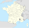
Español: Francia en 1789
English: Map of administrative divisions of France in 1789
Provinces as follows, in the format English name (French name, Year of union; Capital):
- Royal Domain (Île-de-France, 987, Paris)
- Berry (Berry, 1101, Bourges)
- Duchy of Orléanais (Orléanais, 1198, Orléans)
- Normandy (Normandie, 1204, Rouen)
- Languedoc, mainly the County of Toulouse (Languedoc, 1270, Toulouse)
- Lyonnais (Lyonnais, 1313, Lyon)
- Dauphiné, (Dauphiné, 1349, Grenoble)
- County of Champagne (Champagne, 1361, Troyes)
- Aunis, a fief of Aquitaine (Aunis, 1371, La Rochelle)
- Saintonge (Saintonge, 1371, Saintes)
- Poitou (Poitou, 1416, Poitiers)
- Duchy of Aquitaine (Aquitaine, 1453, Bordeaux), taken from England and split into provinces of Gascogne (Armagnac) and Guyenne (Bordeaux), but excluding the viscounties of Foix, Béarn, Bigorre and Périgord (kept by Navarre)
- Duchy of Burgundy (Bourgogne, 1477, Dijon)
- Picardy (Picardie, 1482, Amiens)
- Anjou (Anjou, 1482, Angers)
- County of Provence (Provence, 1482, Aix-en-Provence)
- County of Angoulême (Angoumois, 1515, Angoulême)
- Duchy of Bourbon (Bourbonnais, 1527, Moulins)
- La Marche (Marche, 1527, Guéret)
- Duchy of Britanny (Bretagne, 1532, Rennes)
- County of Maine (Maine, 1584, Le Mans) and County of Perche (Perche, 1525, Nogent-le-Rotrou)
- Touraine (Touraine, 1584, Tours)
- Limousin (Limousin, 1589, Limoges), excluding Viscounty of Périgord (kept by Navarre)
- County of Foix (Comté de Foix, 1607, Foix) and Viscounty of Périgord (Périgord, 1607, Périgueux, attached to province of Guyenne), both former fiefs from Navarre
- Duchy of Auvergne (Auvergne, 1610, Clermont-Ferrand)
- Viscounty of Béarn (Béarn, 1620, Pau)
- Alsace (Alsace, 1648, Strasbourg)
- County of Artois, a fief of the Habsburgs' Spanish Netherlands (Artois, 1659, Arras)
- Roussillon (Roussillon, 1659, Perpignan)
- Flanders, a fief of the Habsburgs' Spanish Netherlands (Flandre, 1668, Lille)
- Free County of Burgundy (Franche-Comté, 1678, Besançon)
- Duchy of Lorraine, a personal territory of Stanisław I of Poland within the Holy Roman Empire (Lorraine, 1766, Nancy)
- Corsica (Corse, 1768, Ajaccio)
The following were not provinces of France before the Revolution, but joined or were annexed to France after it, when departments had replaced all former provinces:
- Duchy of Nivernais (Nivernais, 1789, Nevers)
- Comtat Venaissin, a Papal fief (Comtat Venaissin, 1791, Avignon)
- County of Saarwerden (Comté de Sarrewerden, 1793)
- Principality of Salm-Salm (Principauté de Salm-Salm, 1793)
- Imperial Free City of Mulhouse (Mulhouse, 1798)
- Principality of Montbéliard (Principauté de Montbéliard, 1816, Montbéliard)
- Duchy of Savoy, a state of the Kingdom of Sardinia-Piedmont (Savoie, 1860, Chambéry)
- County of Nice, a state of the Kingdom of Sardinia-Piedmont (Comté de Nice, 1860, Nice)
- Free cities of Menton and Roquebrune (1861), joining France after the separation (under the protectorate of Sardinia) in 1848 from Monaco
|


