Fichier:Postcard of Il Kal Grande in Sarajevo between 1932-1941.jpg

Taille de cet aperçu : 800 × 584 pixels. Autres résolutions : 320 × 234 pixels | 640 × 467 pixels | 944 × 689 pixels.
Fichier d’origine (944 × 689 pixels, taille du fichier : 137 kio, type MIME : image/jpeg)
Ce fichier et sa description proviennent de Wikimedia Commons.
Description
| Description |
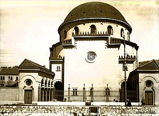
English: Postcard of Il Kal Grande in Sarajevo between 1932-1941. Illegible script in the bottom left corner where the producer and date should stand suggest only possibility of a date "1939"; in the bottom right corner is visible two word label, with first part distinguishable "Sarajevo" and second part illegible. It was new Sefardi (Kal Grande) temple built in 1932 and demolished by German occupiers in 1941. After the Second World War temple was given by Sarajevo Jewish community to the City and rebuilt and used as "Bosnian Cultural Center" (BKC for short) ever since. |
| Date | années 1930 |
| Source | Old postcard from Internet |
| Auteur | Unknown (illegible script in the bottom left and bottom right) |
| Lieu de la prise de vue | | Voir cet endroit et d’autres images sur : OpenStreetMap |
|---|
Conditions d’utilisation
This work first published in Yugoslavia is in the public domain because its copyright expired pursuant to the Yugoslav Copyright Act of 1978 which provided for copyright term of the life of the author plus 50 years, respectively 25 years for photograph or a work of applied art. This applies to works already in the public domain before the breakup of SFR Yugoslavia in 1991.
The work meets one of the following criteria:
A source should be included so that the status can be verified. After this date, use the templates for the Yugoslavian successor states: {{PD-Slovenia}}, {{PD-Croatia}}, {{PD-Bosnia and Herzegovina}}, {{PD-Macedonia}}, {{PD-Montenegro}} or {{PD-Serbia}}.
|
Historique du fichier
Cliquer sur une date et heure pour voir le fichier tel qu'il était à ce moment-là.
| Date et heure | Vignette | Dimensions | Utilisateur | Commentaire | |
|---|---|---|---|---|---|
| actuel | 26 juin 2018 à 03:29 | | 944 × 689 (137 kio) | Santasa99 | User created page with UploadWizard |
Utilisation du fichier
La page suivante utilise ce fichier :
Usage global du fichier
Les autres wikis suivants utilisent ce fichier :
- Utilisation sur en.wikipedia.org
- Utilisation sur es.wikipedia.org
- Utilisation sur he.wikipedia.org
- Utilisation sur hr.wikipedia.org
- Utilisation sur id.wikipedia.org
- Utilisation sur it.wikipedia.org
- Utilisation sur mk.wikipedia.org
- Utilisation sur www.wikidata.org