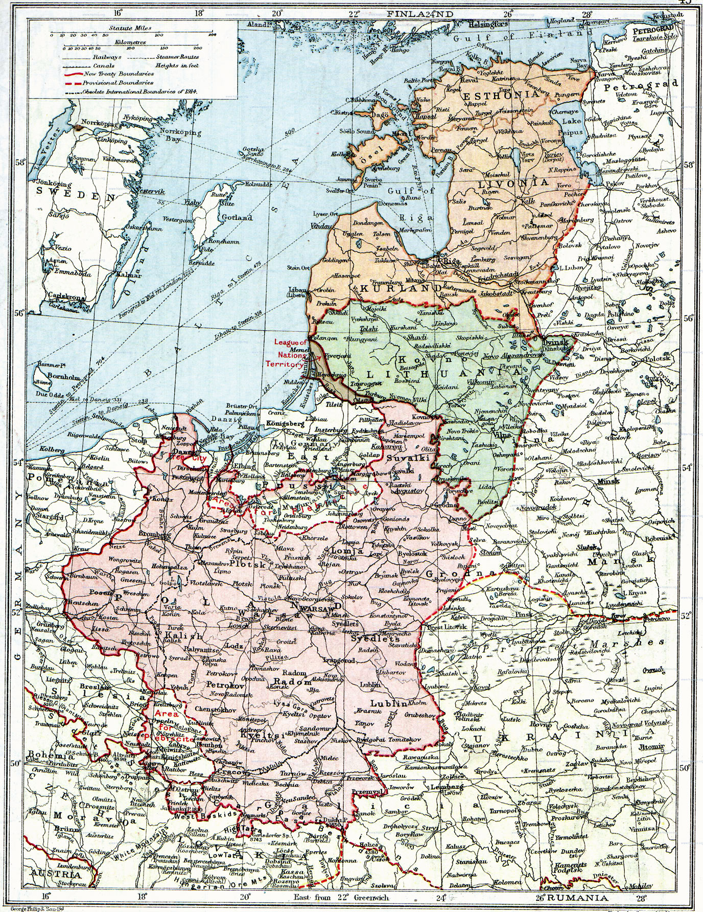
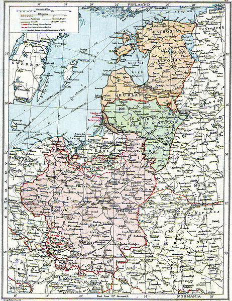
Fichier:Poland & The New Baltic States.jpg
Fichier d’origine (1 376 × 1 784 pixels, taille du fichier : 1,22 Mio, type MIME : image/jpeg)
Ce fichier et sa description proviennent de Wikimedia Commons.
| Description |
English: Map of Poland, en:Lithuania, en:Courland, en:Livonia and en:Esthonia published in the 1920 edition of The Peoples Atlas by London Geographical Institute.
The map shows the situation after the treaties of Versailles and Brest-Litovsk and before the en:Peace of Riga and the organization and recognition of the nation-states of en:Estonia and en:Latvia. Note that most names featured on this map are pre-1914 Russian names put in English transcription, rather than local or English names as such. |
| Date | |
| Source |
This uploaded map is a photoshopped version of the original image located at Image:London-geographical-institute the-peoples-atlas 1920 poland-and-the-new-baltic-states.jpg or [1]. Originally uploaded to EN Wikipedia as en:Image:Poland & The New Baltic States.jpg by en:User:MaGioZal 26 December 2007 |
| Auteur | London Geographical Institute |
| Autorisation (Réutilisation de ce fichier) |
According to the site, there are no copyrights to this map. |
| Autres versions | Image:London-geographical-institute the-peoples-atlas 1920 poland-and-the-new-baltic-states.jpg |
Ce document est dans le domaine public aux États-Unis. Ceci s'applique aux travaux des États-Unis où le copyright a expiré, souvent parce que sa première publication s'est produite avant le 1er janvier 1929. Voir cette page pour davantage d'explication.
|
 | |
 |
Cette image peut ne pas être dans le domaine public en dehors des États-Unis (ceci s'applique particulièrement au Canada, en Chine (pas Hong Kong, Macao, ni Taïwan), en Allemagne ou en Suisse). Le créateur et l'année de la publication sont l'information essentielle et doivent être fournis.
|
Historique du fichier
Cliquer sur une date et heure pour voir le fichier tel qu'il était à ce moment-là.
| Date et heure | Vignette | Dimensions | Utilisateur | Commentaire | |
|---|---|---|---|---|---|
| actuel | 26 juin 2010 à 16:06 | | 1 376 × 1 784 (1,22 Mio) | Ras67 | losslessly cropped with Jpegcrop |
| 3 août 2008 à 09:47 |  | 1 506 × 1 996 (1,28 Mio) | Rcbutcher | {{Information |Description=Map of Poland, Lithuania, Courland, Livonia and Esthonia published in the 1920 edition of ''The Peoples Atlas'' by London Geographical Institute. The map shows the situation after the treaties of [[Treaty of |
Utilisation du fichier
Les 3 pages suivantes utilisent ce fichier :
Usage global du fichier
Les autres wikis suivants utilisent ce fichier :
- Utilisation sur ar.wikipedia.org
- Utilisation sur bat-smg.wikipedia.org
- Utilisation sur ba.wikipedia.org
- Utilisation sur ca.wikipedia.org
- Utilisation sur da.wikipedia.org
- Utilisation sur de.wikipedia.org
- Utilisation sur en.wikipedia.org
- Utilisation sur et.wikipedia.org
- Utilisation sur fi.wikipedia.org
- Utilisation sur gl.wikipedia.org
- Utilisation sur it.wikipedia.org
- Utilisation sur ja.wikipedia.org
- Utilisation sur lt.wikipedia.org
- Utilisation sur lt.wikibooks.org
- Utilisation sur lv.wikipedia.org
- Utilisation sur no.wikipedia.org
- Utilisation sur ro.wikipedia.org
- Utilisation sur ru.wikipedia.org
- Utilisation sur sl.wikipedia.org
- Utilisation sur sr.wikipedia.org
- Utilisation sur sv.wikipedia.org
- Utilisation sur tr.wikipedia.org
- Utilisation sur uk.wikipedia.org
Voir davantage sur l’utilisation globale de ce fichier.