Fichier:Paris Metro line 2 map (with land cover).svg

Taille de cet aperçu PNG pour ce fichier SVG : 800 × 521 pixels. Autres résolutions : 320 × 208 pixels | 640 × 417 pixels | 1 024 × 667 pixels | 1 280 × 834 pixels | 2 560 × 1 667 pixels | 1 371 × 893 pixels.
Fichier d’origine (Fichier SVG, nominalement de 1 371 × 893 pixels, taille : 3,42 Mio)
Ce fichier et sa description proviennent de Wikimedia Commons.
Description
| Titre |
Paris Metro line 2 map (with land cover).svg |
|||||||||
| Description |
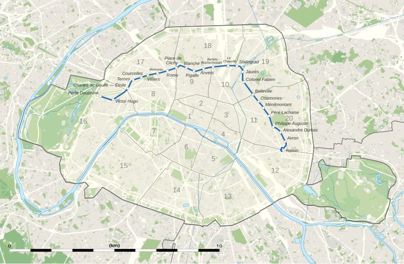
English: Map of the Paris Métro Line 2 with districts, derivated from File:Numbered map of Paris with arrondissements.svg and File:Paris department land cover map, January 2012.svg.
Français : Carte de la ligne 2 du métro de Paris with arrondissements, basée sur File:Numbered map of Paris with arrondissements.svg and File:Paris department land cover map, January 2012.svg. |
|||||||||
| SVG information | Le code de ce fichier SVG n'est pas valide en raison de 26 erreurs. Cette carte W3C-invalide a été créée avec Adobe Illustrator Cette carte SVG utilise du texte encapsulé qui peut être traduit facilement à l'aide d'un éditeur de texte. |
|||||||||
| Date | ||||||||||
| Source |
Travail personnel
|
|||||||||
| Créé par |
User:Sting / OpenStreetMap / 144p |
|||||||||
| Autorisation (Réutilisation de ce fichier) |
|
|||||||||
| Données géotemporelles | ||||||||||
| Date représentée | ||||||||||
| Lieu | Paris 48°51′24″N 2°21′03″E / 48.8567°N 2.3508°E | |||||||||
| Système de coordonnées | WGS84 datum | |||||||||
| Échelle | 1:124,000 (precision: 31 m) | |||||||||
| Orientation |
 |
|||||||||
| Rectangle englobant |
|
|||||||||
| Géoréférencement | Si c'est inapproprié, définissez warp_status = skip pour masquer. | |||||||||
| Autres versions |
|
|||||||||


.svg?uselang=fr)
.svg¶ms=48.8567_N_2.3508_E_)
.svg¶ms=48.9125_N_2.2125_E_)
.svg¶ms=48.9125_N_2.475_E_)
.svg¶ms=48.800_N_2.2125_E_)
.svg¶ms=48.800_N_2.475_E_)
Conditions d’utilisation
Eric Gaba, Wikimedia Commons user Sting, en tant que détenteur des droits d’auteur sur cette œuvre, la publie sous la licence suivante :
Ce fichier est disponible selon les termes de la licence Creative Commons Attribution – Partage dans les Mêmes Conditions 3.0 (non transposée).
Attribution: Eric Gaba, Wikimedia Commons user Sting
- Vous êtes libre :
- de partager – de copier, distribuer et transmettre cette œuvre
- d’adapter – de modifier cette œuvre
- Sous les conditions suivantes :
- paternité – Vous devez donner les informations appropriées concernant l'auteur, fournir un lien vers la licence et indiquer si des modifications ont été faites. Vous pouvez faire cela par tout moyen raisonnable, mais en aucune façon suggérant que l’auteur vous soutient ou approuve l’utilisation que vous en faites.
- partage à l’identique – Si vous modifiez, transformez, ou vous basez sur cette œuvre, vous devez distribuer votre contribution sous la même licence ou une licence compatible avec celle de l’original.
| Ce travail contient des informations issues de OpenStreetMap mises à disposition sous les termes de la Licence Open Database (ODbL).
L'ODbL n'exige aucune licence en particulier pour les cartes produites à partir de données placées sous l'ODbL. Avant le 1er août 2020, les tuiles des cartes produites par la Fondation OpenStreetMap étaient placées sous la licence CC-BY-SA-2.0. Les cartes produites par d'autres personnes peuvent être placées sous des licences différentes. |
Historique du fichier
Cliquer sur une date et heure pour voir le fichier tel qu'il était à ce moment-là.
| Date et heure | Vignette | Dimensions | Utilisateur | Commentaire | |
|---|---|---|---|---|---|
| actuel | 5 septembre 2018 à 18:44 | | 1 371 × 893 (3,42 Mio) | JoKalliauer | Workaround for https://github.com/svg/svgo/issues/878 |
| 14 janvier 2018 à 11:20 |  | 1 371 × 893 (20,32 Mio) | 144p | Reverted to version as of 09:08, 14 January 2018 (UTC) | |
| 14 janvier 2018 à 11:16 |  | 1 371 × 893 (20,32 Mio) | 144p | Try opacity 50% and line width 7px | |
| 14 janvier 2018 à 11:08 |  | 1 371 × 893 (20,32 Mio) | 144p | {{Information |Description ={{en|1=Map of the Paris Métro Line 2 with districts, derivated from File:Numbered map of Paris with arrondissements.svg and File:Paris department land cover map, January 2012.svg.}}... |
Utilisation du fichier
Aucune page n’utilise ce fichier.
.svg)