Fichier:PIA18408-MarsCuriosityRover-TraverseMap-Sol705-20140731.jpg

Fichier d’origine (3 300 × 2 550 pixels, taille du fichier : 1,29 Mio, type MIME : image/jpeg)
Ce fichier et sa description proviennent de Wikimedia Commons.
Description
| Description |
English: 08.01.2014
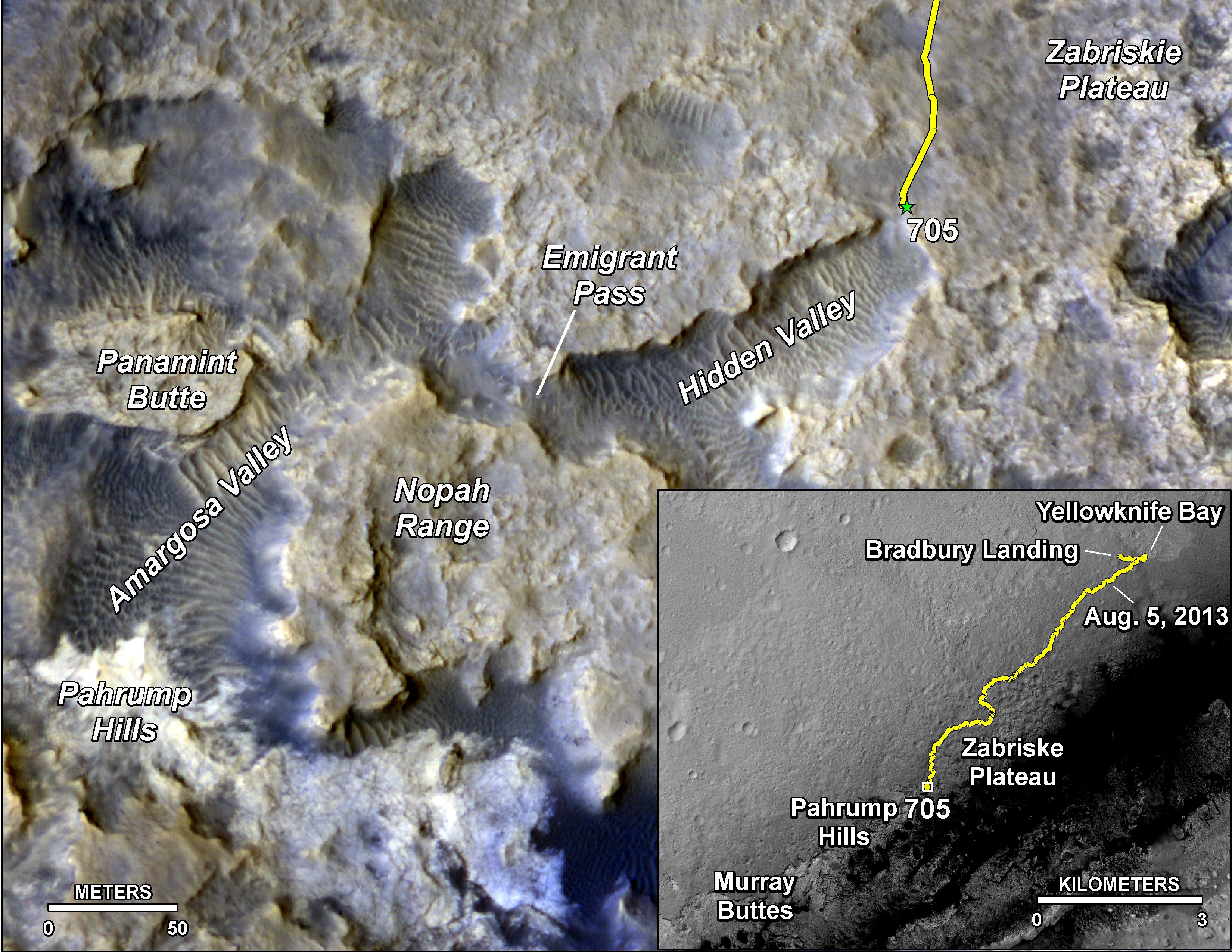
Sandy Martian Valleys in Curiosity's Near Future http://mars.jpl.nasa.gov/msl/multimedia/images/?ImageID=6482 The main map here shows the assortment of landforms near the location of NASA's Curiosity Mars rover as the rover's second anniversary of landing on Mars nears. The gold traverse line entering from upper right ends at Curiosity's position as of the 705th Martian day, or sol, of the mission on Mars (July 31, 2014). The inset map shows the mission's entire traverse from the landing on Aug. 5, 2012, PDT (Aug. 6, UTC) to Sol 705, and the remaining distance to long-term science destinations near Murray Buttes, at the base of Mount Sharp. The label "Aug. 5, 2013" indicates where Curiosity was one year after landing. Curiosity spent much of July 2014 crossing an upland area called "Zabriskie Plateau," where embedded, sharp rocks presented hazards for the rover's wheels. The traverse line enters the main map at the rover's location as of Sol 692 (July 17, 2014). A near-term science destination is the "Pahrump Hills" feature near the lower left corner. Scientists anticipate that outcrop rock there may provide a preview of a geological unit that is part of the base of Mount Sharp, rather than floor of Gale Crater. Between the Sol 705 location and Pahrump Hills, the rover's anticipated route dips into sandy-floored valleys. Scale bars are 50 meters (164 feet) on the main map and 3 kilometers (1.9 miles) on the inset map. The base images for the map are from the High Resolution Imaging Science Experiment (HiRISE) camera on NASA's Mars Reconnaissance Orbiter. For broader-context views of the area that Curiosity is crossing within Gale Crater, see http://photojournal.jpl.nasa.gov/catalog/PIA16064 and http://photojournal.jpl.nasa.gov/catalog/pia15687. Before the first anniversary of the landing, NASA's Mars Science Laboratory Project, which built and operates Curiosity, achieved its main science objective of determining whether Mars ever offered environmental conditions favorable for microbial life. Rock-powder samples drilled from two mudstone rocks at Yellowknife Bay and analyzed onboard yielded evidence for an ancient lakebed with mild water, the chemical elements needed for life and a mineral source of energy used by some Earth microbes. NASA's Jet Propulsion Laboratory, a division of the California Institute of Technology, Pasadena, manages the Mars Science Laboratory Project and Mars Reconnaissance Orbiter Project for NASA's Science Mission Directorate, Washington.Polski: 08.01.2014
Piaszczyste Marsjańskie Doliny nabliższą przyszłością łazika Curiosity Dostęp do tekstu źródłowego w języku angielskim Mapa główna pokazuje zestaw obiektów geograficznych znajdujących się w pobliżu znajdowania się należącego do NASA łazika Curiosity w drugą rocznicę jego lądowania na Marsie. Złota linia prowadzi od wyższego prawego końca wskazującego pozycję łazika Curiosity w 705 marsjańskim dniu (31 lipca 2014). Wklejona mapka wewnętrzna pokazuje trawers całej misji od miejsca lądowania 5 sierpnia 2012, PDT (6 sierpnia, UTC) do miejsca w którym Curiosity był w Sol 705 i pozostały długo terminowy cel naukowy blisko Murray Buttes, w podstawie Mount Sharp. Adnotacja "Aug. 5, 2013" wskazuje gdzie Curiosity był rok po wylądowaniu. Curiosity spędził większą część lipca 2014 przechodząc przez obszar wyżynny nazywany "Zabriskie Plateau," gdzie osadzone w podłożu ostre skały stanowiły zagrożenie dla kół łazika. Linia trawersu łazika wchodzi na mapę główną w miejscu oznaczającym pozycję łazika w Sol 692 (17 lipca 2014). Najbliższy naukowy cel podróży jest "Pahrump Hills" oznaczony w lewym dolnym rogu. Naukowcy przewidują, że odkrywka skał może stanowić zapowiedź jednostki geologicznej, która jest częścią stóp Mount Sharp, a nie na podłożem Gale Crater. Pomiędzy miejscem Sol 705 i Pahrump Hills, przewidywane trasy łazika obniżą się w piaszczyste, nisko położone doliny. Na głównej mapie podziałka liniowa skali oznacza 50 metrów 3 kilometry na mapie wewnętrznej. Podstawowe zdjęcie do wykonania mapy pochodzi od teleskopu zwierciadlanego ang. High Resolution Imaging Science Experiment (HiRISE) umieszczonego na należącym do NASA orbiterze Mars Reconnaissance Orbiter. W celu uzyskania szerszego kontekstu widoku miejsca znajdowania się łazika Curiosity przechodzącego przez Gale Crater, zobacz http://photojournal.jpl.nasa.gov/catalog/PIA16064 i http://photojournal.jpl.nasa.gov/catalog/pia15687. Przed pierwszą rocznicę lądowania, należący do NASA Mars Science Laboratory Project, który zbudował i prowadzi łazik Curiosity, osiągnął swój główny cel naukowy, mianowicie ustalił, czy Mars kiedykolwiek oferował warunki środowiskowe korzystne dla mikroorganizmów. Próbki pyłu uzyskanego ze zmielonych mułowców, uzyskane w wyniku wiercenia dwóch skał w Yellowknife Bay i analizowane na pokładzie dały dowód na istnienie na Marsie w odległych epokach mis jeziornych z łagodnym nurtem wody, pierwiastków niezbędnych do życia i źródła mineralne energii wykorzystywane przez niektóre drobnoustroje na Ziemi. Należące do NASA Jet Propulsion Laboratory, będące oddziałem instytutu California Institute of Technology, kieruje łazikiem Mars Science Laboratory Project i orbiterem Mars Reconnaissance Orbiter Project dla należącego do NASA dyrektoriatu Science Mission Directorate, z Waszyntonu. |
| Date | |
| Source | http://mars.jpl.nasa.gov/msl/images/Mars-Curiosity-Traverse-Map-Sol-705-PIA18408-full.jpg |
| Auteur | NASA/JPL-Caltech/Univ. of Arizona |
Conditions d’utilisation
| Ce fichier provient de la NASA. Sauf exception, les documents créés par la NASA ne sont pas soumis à copyright. Pour plus d'informations, voir la politique de copyright de la NASA. | ||
 |
Attention :
|
Historique du fichier
Cliquer sur une date et heure pour voir le fichier tel qu'il était à ce moment-là.
| Date et heure | Vignette | Dimensions | Utilisateur | Commentaire | |
|---|---|---|---|---|---|
| actuel | 2 août 2014 à 02:31 | | 3 300 × 2 550 (1,29 Mio) | Drbogdan | User created page with UploadWizard |
Utilisation du fichier
La page suivante utilise ce fichier :
Usage global du fichier
Les autres wikis suivants utilisent ce fichier :
- Utilisation sur en.wikipedia.org
- Utilisation sur pl.wikipedia.org
- Utilisation sur uk.wikipedia.org
- Utilisation sur zh.wikipedia.org