Fichier:PIA17944-MarsCuriosityRover-AfterCrossingDingoGapSanddune-20140209.jpg

Fichier d’origine (4 326 × 2 856 pixels, taille du fichier : 2,64 Mio, type MIME : image/jpeg)
Ce fichier et sa description proviennent de Wikimedia Commons.
Description
| Description |
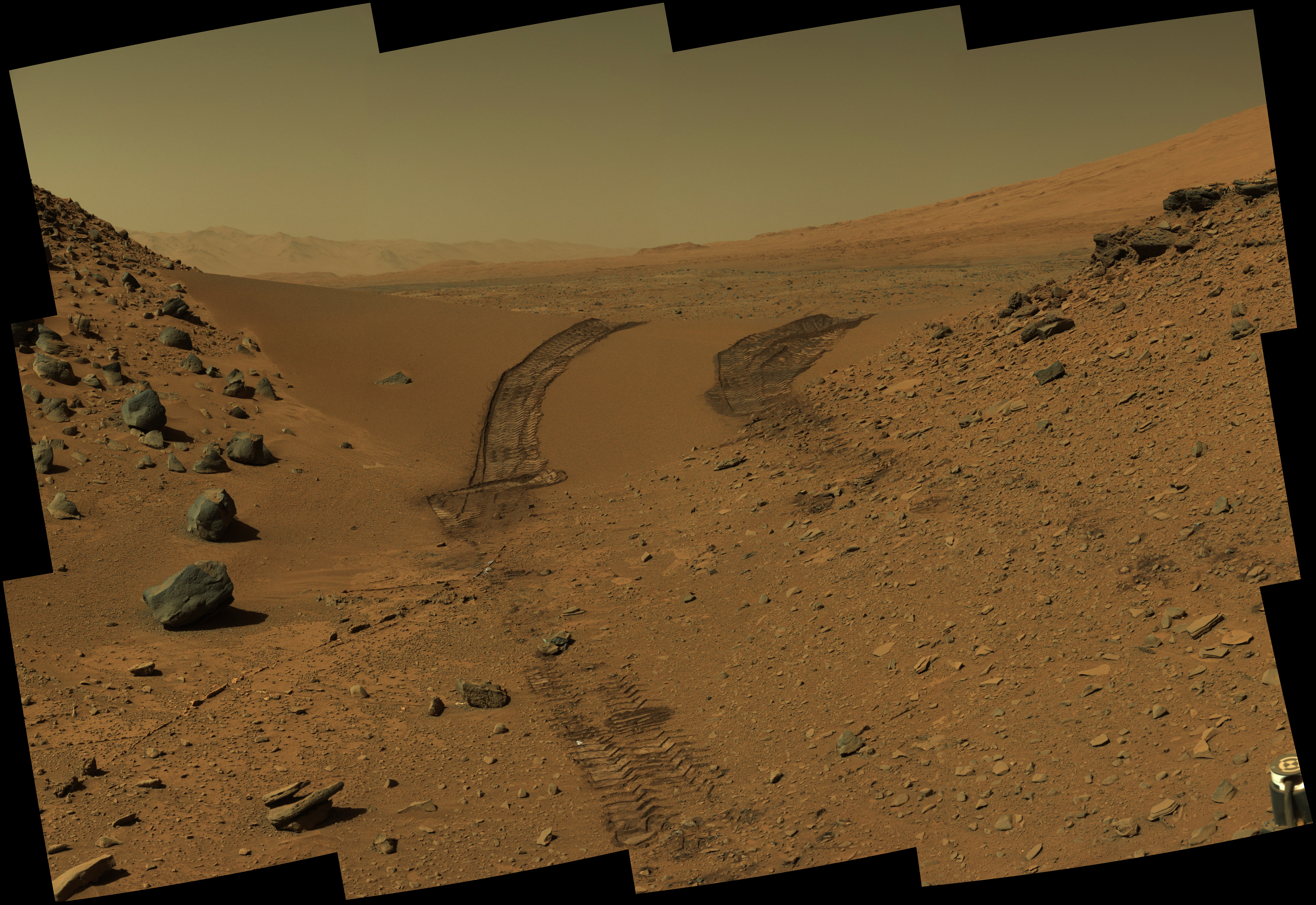
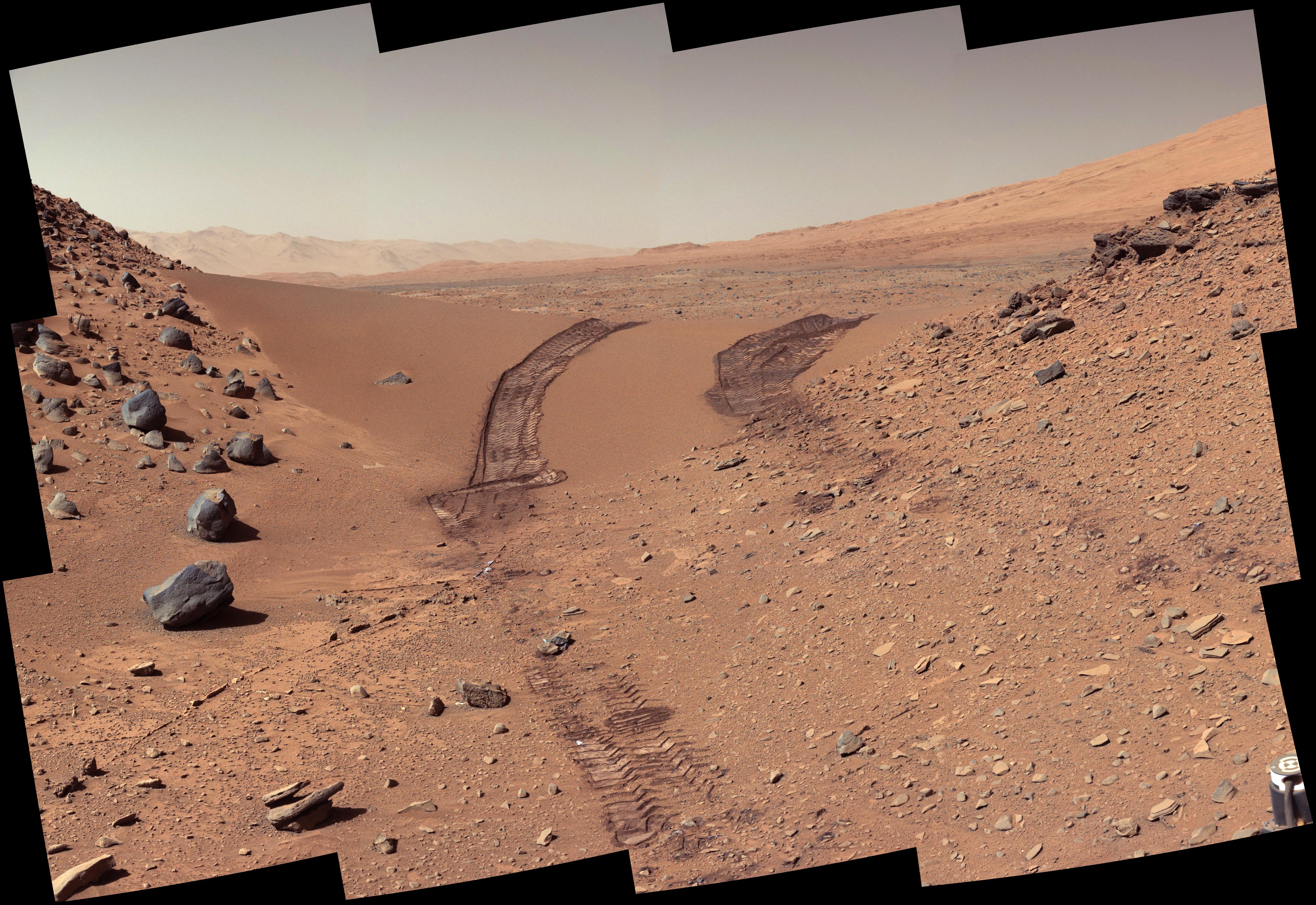
English: PIA17944: Curiosity's Color View of Martian Dune After Crossing It
http://photojournal.jpl.nasa.gov/catalog/PIA17944 This look back at a dune that NASA's Curiosity Mars rover drove across was taken by the rover's Mast Camera (Mastcam) during the 538th Martian day, or sol, of Curiosity's work on Mars (Feb. 9, 2014). The rover had driven over the dune three days earlier. For scale, the distance between the parallel wheel tracks is about 9 feet (2.7 meters). The dune is about 3 feet (1 meter) tall in the middle of its span across an opening called "Dingo Gap." This view is looking eastward. The image has been white balanced to show what the Martian surface materials would look like if under the light of Earth's sky. A version with raw color, as recorded by the camera under Martian lighting conditions, is available as Figure 1. NASA's Jet Propulsion Laboratory, a division of the California Institute of Technology, Pasadena, manages the Mars Science Laboratory Project for NASA's Science Mission Directorate, Washington. JPL designed and built the project's Curiosity rover. Malin Space Science Systems, San Diego, built and operates the rover's Mastcam. More information about Curiosity is online at http://www.nasa.gov/msl and http://mars.jpl.nasa.gov/msl/. Image Credit: NASA/JPL-Caltech/MSSS Polski: Kolorowy widok marsjańskich wydm widziany oczami łazika Curiosity po ich przejściu
To spojrzenie do tyłu na marsjańskie wydmy, zostało wykonane przez jedną z pośród dwóch kamer masztowych łazika Curiosity, podczas 538 marsjańskiej doby, czyli 09 lutego 2014. Łazik pokonał wydmy trzy dni wcześniej. Dla porównania, ślady kół łazika wyrażają ich rozpiętość, która wynosi 2,7 metra. Wysokość wydmy wynosi 1 metr, a w jej środku znajduje się luka o nazwie "Luka Dingo". Widok ten, jest skierowany w kierunku wschodnim. Zdjęcie było poddane regulacji równowagi bieli, aby pokazać powierzchnię Marsa tak, jakby wyglądała w warunkach oświetleniowych na Ziemi. Wersja w surowym formacie, zarejestrowanym przez kamerę w marsjańskich warunkach oświetleniowych, jest dostępna na zdjęciu (figure 1). Należące do NASA Jet Propulsion Laboratory, będące oddziałem California Institute of Technology w Pasadenie, kieruje projektem Mars Science Laboratory dla należącego do NASA Science Mission Directorate w Waszygtonie. JPL zaprojektowało i zbudowało łazik Curiosity. Malin Space Science Systems z San Diego, zbudowało i steruje kamerami masztowymi łazika (ang. Mastcams). Zdjęcie przypisane do: NASA/JPL-Caltech/MSSS |
| Date | |
| Source | http://photojournal.jpl.nasa.gov/jpeg/PIA17944.jpg |
| Auteur | NASA/JPL-Caltech/MSSS |
Conditions d’utilisation
| Ce fichier provient de la NASA. Sauf exception, les documents créés par la NASA ne sont pas soumis à copyright. Pour plus d'informations, voir la politique de copyright de la NASA. | ||
 |
Attention :
|
Historique du fichier
Cliquer sur une date et heure pour voir le fichier tel qu'il était à ce moment-là.
| Date et heure | Vignette | Dimensions | Utilisateur | Commentaire | |
|---|---|---|---|---|---|
| actuel | 20 février 2014 à 05:06 | | 4 326 × 2 856 (2,64 Mio) | Drbogdan | cropped - maybe better. |
| 20 février 2014 à 04:08 |  | 4 890 × 3 361 (2,37 Mio) | Drbogdan | User created page with UploadWizard |
Utilisation du fichier
Les 3 pages suivantes utilisent ce fichier :
Usage global du fichier
Les autres wikis suivants utilisent ce fichier :
- Utilisation sur ar.wikipedia.org
- Utilisation sur bn.wikipedia.org
- Utilisation sur ca.wikipedia.org
- Utilisation sur de.wikipedia.org
- Utilisation sur en.wikipedia.org
- Utilisation sur en.wikibooks.org
- Utilisation sur es.wikipedia.org
- Utilisation sur fa.wikipedia.org
- Utilisation sur lv.wikipedia.org
- Utilisation sur or.wikipedia.org
- Utilisation sur pl.wikipedia.org
- Utilisation sur pnb.wikipedia.org
- Utilisation sur uk.wikipedia.org
- Utilisation sur vi.wikipedia.org
- Utilisation sur zh.wikipedia.org