Fichier:NovoLisice.jpg

Taille de cet aperçu : 587 × 600 pixels. Autres résolutions : 235 × 240 pixels | 470 × 480 pixels | 752 × 768 pixels | 1 002 × 1 024 pixels | 2 005 × 2 048 pixels | 3 000 × 3 065 pixels.
Fichier d’origine (3 000 × 3 065 pixels, taille du fichier : 3,5 Mio, type MIME : image/jpeg)
Ce fichier et sa description proviennent de Wikimedia Commons.
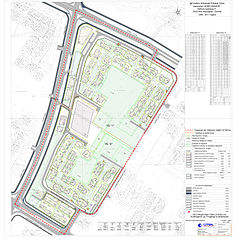
| Description | The graphical scheme of the Detailed urban plan for a settlement (urban area A) within the Aerodrom municipality of the city of Skopje, Republic of Macedonia. The graphical scheme contains different zones which are designated with different colors in the graph on the right side of the photo. | |||
| Date | ||||
| Source | [1] | |||
| Auteur | Council of the Municipality of Aerodrom | |||
| Autorisation (Réutilisation de ce fichier) |
|

![[1]](http://www.aerodrom.gov.mk/Images/dup/NovoLisice.jpg)
Historique du fichier
Cliquer sur une date et heure pour voir le fichier tel qu'il était à ce moment-là.
| Date et heure | Vignette | Dimensions | Utilisateur | Commentaire | |
|---|---|---|---|---|---|
| actuel | 3 avril 2010 à 10:54 | | 3 000 × 3 065 (3,5 Mio) | Модернист | {{Information |Description=The graphical scheme of the Detailed urban plan for a settlement (urban area A) within the Aerodrom municipality of the city of Skopje, Republic of Macedonia. The graphical scheme contains different zones which are desig |
Utilisation du fichier
Les 2 pages suivantes utilisent ce fichier :
Usage global du fichier
Les autres wikis suivants utilisent ce fichier :
- Utilisation sur an.wikipedia.org
- Utilisation sur bn.wikipedia.org
- Utilisation sur en.wikipedia.org
- Utilisation sur es.wikipedia.org
- Utilisation sur ha.wikipedia.org
- Utilisation sur hu.wikipedia.org
- Utilisation sur ja.wikipedia.org
- Utilisation sur mk.wikipedia.org
- Utilisation sur ml.wikipedia.org
- Utilisation sur no.wikipedia.org
- Utilisation sur sr.wikipedia.org
- Utilisation sur vi.wikipedia.org
- Utilisation sur www.wikidata.org
- Utilisation sur zh.wikipedia.org