Fichier:Northern Ireland rail network sb.svg

Taille de cet aperçu PNG pour ce fichier SVG : 800 × 435 pixels. Autres résolutions : 320 × 174 pixels | 640 × 348 pixels | 1 024 × 557 pixels | 1 280 × 697 pixels | 2 560 × 1 393 pixels | 2 275 × 1 238 pixels.
Fichier d’origine (Fichier SVG, nominalement de 2 275 × 1 238 pixels, taille : 453 kio)
Ce fichier et sa description proviennent de Wikimedia Commons.
Description
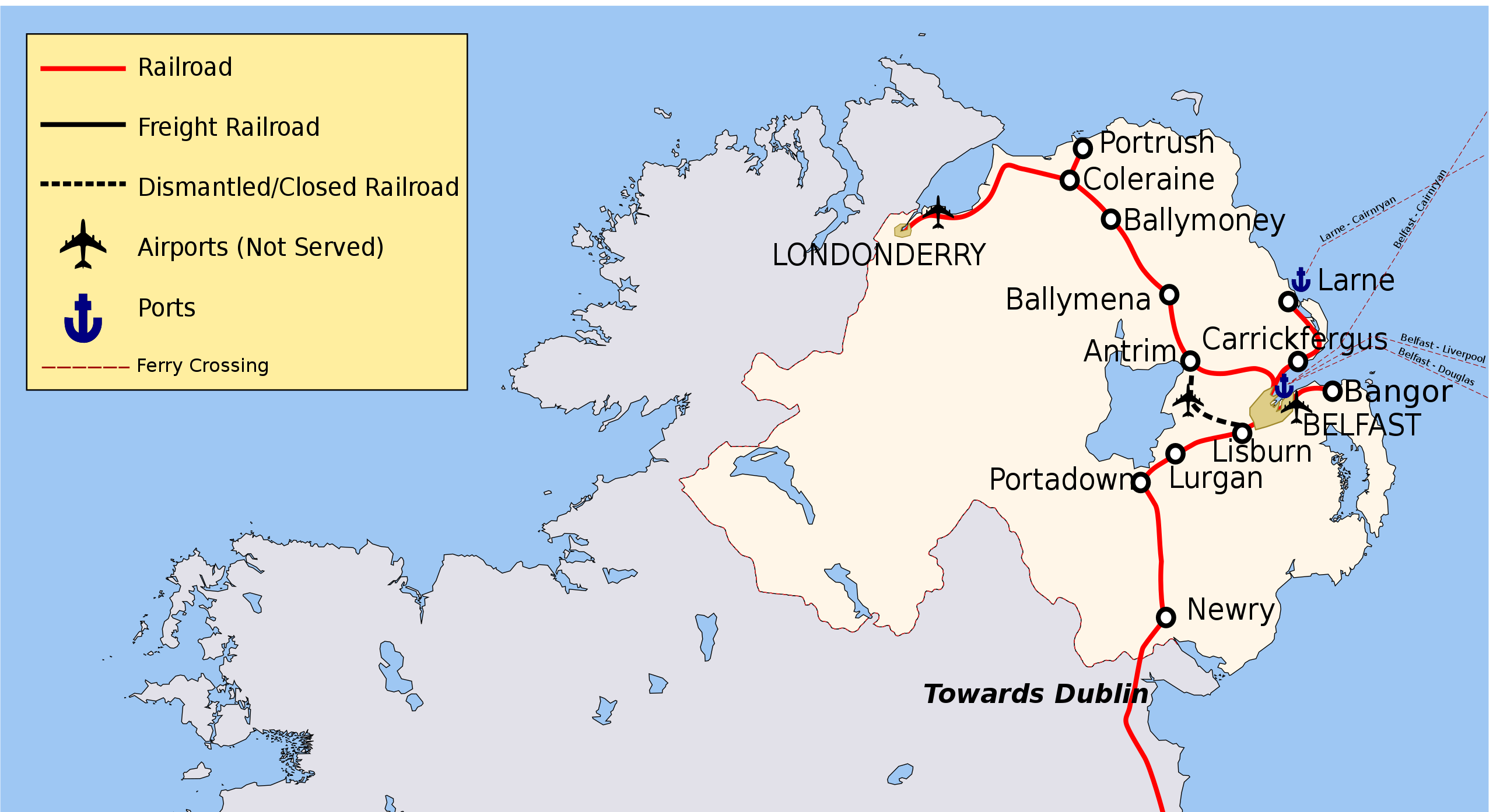
| Description | Map of Rail Networks in Northern Ireland. |
| Date | (UTC) |
| Source |
Ce fichier est dérivé de : Ireland rail network sb.svg:  |
| Auteur |
|
| Autres versions |
[]
|

| Cette image a été retouchée, ce qui signifie qu'elle a été modifiée par ordinateur et est différente de l'image d'origine. Liste des modifications : Cropped. L'image d'origine se trouve ici : Ireland rail network sb.svg:
|
Conditions d’utilisation
Moi, en tant que détenteur des droits d’auteur sur cette œuvre, je la publie sous les licences suivantes :
Ce fichier est disponible selon les termes de la licence Creative Commons Attribution – Partage dans les Mêmes Conditions 3.0 (non transposée).
- Vous êtes libre :
- de partager – de copier, distribuer et transmettre cette œuvre
- d’adapter – de modifier cette œuvre
- Sous les conditions suivantes :
- paternité – Vous devez donner les informations appropriées concernant l'auteur, fournir un lien vers la licence et indiquer si des modifications ont été faites. Vous pouvez faire cela par tout moyen raisonnable, mais en aucune façon suggérant que l’auteur vous soutient ou approuve l’utilisation que vous en faites.
- partage à l’identique – Si vous modifiez, transformez, ou vous basez sur cette œuvre, vous devez distribuer votre contribution sous la même licence ou une licence compatible avec celle de l’original.

|
Vous avez la permission de copier, distribuer et modifier ce document selon les termes de la GNU Free Documentation License version 1.2 ou toute version ultérieure publiée par la Free Software Foundation, sans sections inaltérables, sans texte de première page de couverture et sans texte de dernière page de couverture. Un exemplaire de la licence est inclus dans la section intitulée GNU Free Documentation License. |
Vous pouvez choisir l’une de ces licences.
Journal des téléversements d’origine
This image is a derivative work of the following images:
- File:Ireland_rail_network_sb.svg licensed with Cc-by-sa-3.0, GFDL
- 2012-03-02T15:58:58Z Jonto 2268x2801 (469301 Bytes) see http://en.wikipedia.org/wiki/Londonderry_railway_station Map was originally based on RoI data but updated with official NI data
- 2011-09-20T18:42:55Z Rwxrwxrwx 2268x2801 (481722 Bytes) reverted change to name of derry, see [[WP:DERRY]]
- 2010-07-01T11:52:40Z Classical geographer 2268x2801 (469301 Bytes) Since March 2010, the southern part of the [[:en:Western Railway Corridor|]] is open. Have changed that from projected (black dash) to current (red).
- 2010-06-11T01:37:49Z Jonto 2268x2801 (468758 Bytes) More accurate Antrim and Portadown line.
- 2010-06-11T00:48:52Z Jonto 2268x2801 (468301 Bytes) More accurate representation of Northern Ireland network, particularly for Larne line and derry line. More accurate location of airport and defunct line from Lisburn to airport marked as such.
- 2008-09-17T10:41:11Z Stabilo boss 2200x2800 (456823 Bytes)
- 2008-09-17T10:14:33Z Stabilo boss 2200x2800 (456728 Bytes)
- 2008-09-17T10:08:43Z Stabilo boss 2200x2800 (456424 Bytes) [[Category:Rail Transport in Ireland]] [[Category:Ireland]] [[Category:Maps of Ireland]]
- 2008-09-09T22:12:45Z Stabilo boss 2200x2800 (436218 Bytes) {{Information |Description= Map of Rail Networks in Ireland. |Source=Derivative Work using [[:Image:Ireland.svg]] and [[:Image:Ireland_rail_network.svg]] |Date=09 09 2008 |Author= [[User:Stabilo boss|Stabilo boss]] |Permissio
- 2008-09-09T22:07:45Z Stabilo boss 2200x2800 (409932 Bytes) {{Information |Description= Map of Rail Networks in Ireland. |Source=Derivative Work using [[:Image:Ireland.svg]] and [[:Image:Ireland_rail_network.svg]] |Date=09 09 2008 |Author= [[User:Stabilo boss|Stabilo boss]] |Permissio
Téléversé avec derivativeFX
Historique du fichier
Cliquer sur une date et heure pour voir le fichier tel qu'il était à ce moment-là.
| Date et heure | Vignette | Dimensions | Utilisateur | Commentaire | |
|---|---|---|---|---|---|
| actuel | 23 septembre 2019 à 11:52 | | 2 275 × 1 238 (453 kio) | খাঁ শুভেন্দু | File uploaded using svgtranslate tool (https://tools.wmflabs.org/svgtranslate/). Added translation for bn. |
| 18 mai 2017 à 20:25 |  | 2 275 × 1 238 (463 kio) | RaviC | + Ferry interchanges, layout modifications | |
| 24 décembre 2012 à 22:58 |  | 2 275 × 1 238 (451 kio) | RaviC | Fix text issue | |
| 1 décembre 2012 à 13:39 |  | 2 275 × 1 238 (451 kio) | RaviC | == {{int:filedesc}} == {{Information |Description=Map of Rail Networks in Northern Ireland. |Source={{Derived from|Ireland_rail_network_sb.svg|display=50}} |Date=2012-12-01 11:38 (UTC) |Author=*File:Ireland_rail_network_sb.svg: [[User:Stabilo bos... |
Utilisation du fichier
La page suivante utilise ce fichier :
Usage global du fichier
Les autres wikis suivants utilisent ce fichier :
- Utilisation sur en.wikipedia.org
- Utilisation sur ga.wikipedia.org
- Utilisation sur hu.wikipedia.org
- Utilisation sur it.wikivoyage.org
- Utilisation sur ru.wikipedia.org
- Utilisation sur www.wikidata.org