Fichier:NEAT GBT engl.png

Taille de cet aperçu : 539 × 600 pixels. Autres résolutions : 216 × 240 pixels | 431 × 480 pixels | 852 × 948 pixels.
Fichier d’origine (852 × 948 pixels, taille du fichier : 1,91 Mio, type MIME : image/png)
Ce fichier et sa description proviennent de Wikimedia Commons.
Description
| Description |
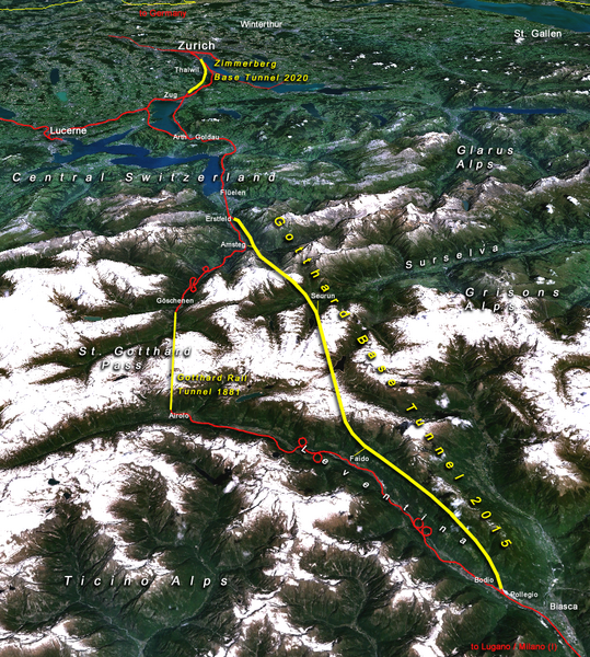
Situation of the northern part of the Gotthard axis as part of the New Railway Link through the Alps NRLA / Alptransit project in Switzerland with Gotthard and Zimmerberg base tunnels |
| Date | |
| Source | topomap: produced with NASA WorldWind 1.3 / overlay drawing by: Cooper.ch |
| Auteur | --Cooper.ch 19:30, 12 August 2006 (UTC) |
| Autorisation (Réutilisation de ce fichier) |
NASA satellite imagery is in public domain, and so is my overlay drawing |
| Autres versions | Original german version on de.wikipedia.org, named Bild:NEAT_Gotthardachse.png |
Conditions d’utilisation
| Ce fichier provient de la NASA. Sauf exception, les documents créés par la NASA ne sont pas soumis à copyright. Pour plus d'informations, voir la politique de copyright de la NASA. | ||
 |
Attention :
|
| Annotations | Cette image est annotée : Voir les annotations sur Wikimedia Commons |


Historique du fichier
Cliquer sur une date et heure pour voir le fichier tel qu'il était à ce moment-là.
| Date et heure | Vignette | Dimensions | Utilisateur | Commentaire | |
|---|---|---|---|---|---|
| actuel | 12 août 2006 à 21:30 | | 852 × 948 (1,91 Mio) | Cooper.ch | {{Information |Description=Situation of the northern axis of the New Railway Link through the Alps NRLA in Switzerland with Gotthard and Zimmerberg base tunnels |Source=topomap: produced with NASA WorldWind 1.3 / drawing overlay by: [[User:Cooper.ch|Coope |
Utilisation du fichier
Les 2 pages suivantes utilisent ce fichier :
Usage global du fichier
Les autres wikis suivants utilisent ce fichier :
- Utilisation sur ast.wikipedia.org
- Utilisation sur bh.wikipedia.org
- Utilisation sur da.wikipedia.org
- Utilisation sur en.wikipedia.org
- Utilisation sur es.wikipedia.org
- Utilisation sur fa.wikipedia.org
- Utilisation sur fi.wikipedia.org
- Utilisation sur he.wikipedia.org
- Utilisation sur hr.wikipedia.org
- Utilisation sur ja.wikipedia.org
- Utilisation sur jv.wikipedia.org
- Utilisation sur ml.wikipedia.org
- Utilisation sur my.wikipedia.org
- Utilisation sur nl.wikipedia.org
- Utilisation sur no.wikipedia.org
- Utilisation sur pt.wikipedia.org
- Utilisation sur rm.wikipedia.org
- Utilisation sur ro.wikipedia.org
- Utilisation sur sh.wikipedia.org
- Utilisation sur sl.wikipedia.org
- Utilisation sur sv.wikipedia.org
- Utilisation sur ta.wikinews.org
- Utilisation sur tr.wikipedia.org
- Utilisation sur zh.wikipedia.org