Fichier:Michigan Congressional Districts, 113th Congress.tif

Taille de cet aperçu PNG pour ce fichier TIF : 556 × 600 pixels. Autres résolutions : 223 × 240 pixels | 445 × 480 pixels | 712 × 768 pixels | 950 × 1 024 pixels | 2 464 × 2 657 pixels.
Fichier d’origine (2 464 × 2 657 pixels, taille du fichier : 1,73 Mio, type MIME : image/tiff)
Ce fichier et sa description proviennent de Wikimedia Commons.
Description
| Description |
English: Map of Congressional Districts in the state of Michigan, reflecting district boundaries current to the 113th United States Congress. |
| Date | |
| Source | National Atlas of the United States (http://nationalatlas.gov/printable/congress.html) |
| Auteur | Department of the Interior |
Conditions d’utilisation
Cette carte a été obtenue d'une édition du
National Atlas of the United States . Comme presque toutes les œuvres du gouvernement fédéral des États-Unis d'Amérique, les travaux du National Atlas sont placés dans le domaine public.Version en ligne : NationalAtlas.gov | Édition imprimée de 1970 : Library of Congress, Perry-Castañeda Library
|
Historique du fichier
Cliquer sur une date et heure pour voir le fichier tel qu'il était à ce moment-là.
| Date et heure | Vignette | Dimensions | Utilisateur | Commentaire | |
|---|---|---|---|---|---|
| actuel | 2 février 2014 à 08:00 | 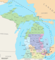 | 2 464 × 2 657 (1,73 Mio) | 7partparadigm | User created page with UploadWizard |
Utilisation du fichier
La page suivante utilise ce fichier :
Usage global du fichier
Les autres wikis suivants utilisent ce fichier :
- Utilisation sur fa.wikipedia.org
- Utilisation sur it.wikipedia.org
- Utilisation sur ru.wikipedia.org
- Utilisation sur uk.wikipedia.org
- Utilisation sur zh.wikipedia.org