Fichier:Meso-WW1-2.jpg
Taille de cet aperçu : 633 × 599 pixels. Autres résolutions : 254 × 240 pixels | 507 × 480 pixels | 752 × 712 pixels.
Fichier d’origine (752 × 712 pixels, taille du fichier : 87 kio, type MIME : image/jpeg)
Ce fichier et sa description proviennent de Wikimedia Commons.
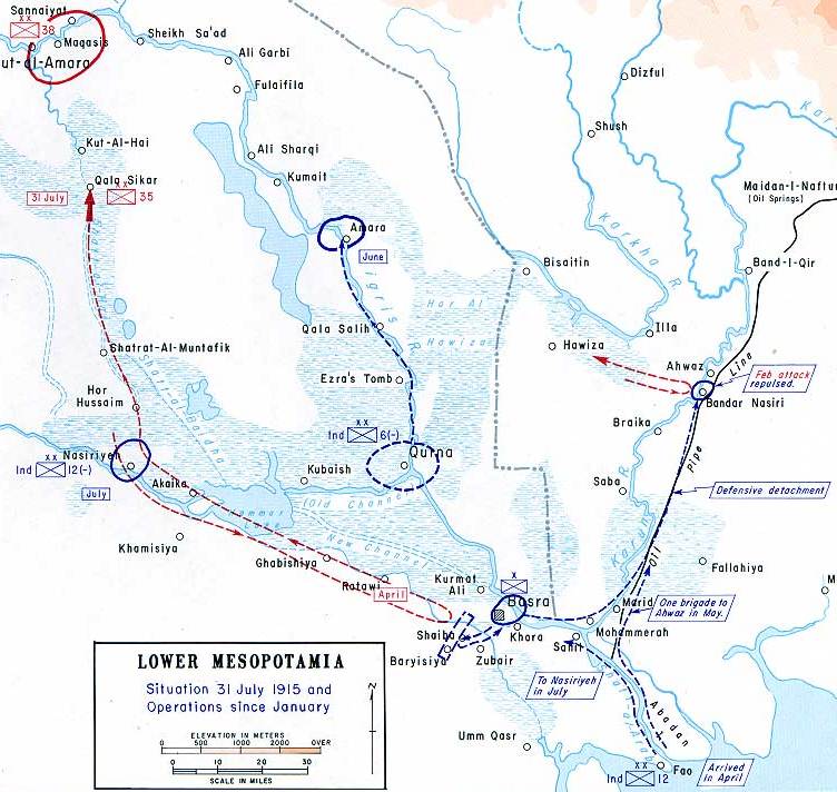
| Description | This map shows the British advance into Southern Mesopotamia, 1915. | ||||||
| Source |
available on the West Point web site at: http://www.dean.usma.edu/history/web03/atlases/great%20war/great%20war%20%20pages/great%20war%20map%2046.htm Originally uploaded to EN Wikipedia by Cglassey 28 April 2006 |
||||||
| Auteur | created by the Department of Military Art and Engineering, at the U.S. Military Academy (West Point). | ||||||
| Autorisation (Réutilisation de ce fichier) |
|
||||||

Historique du fichier
Cliquer sur une date et heure pour voir le fichier tel qu'il était à ce moment-là.
| Date et heure | Vignette | Dimensions | Utilisateur | Commentaire | |
|---|---|---|---|---|---|
| actuel | 4 novembre 2007 à 13:50 | | 752 × 712 (87 kio) | Rcbutcher | {{Information |Description=This map shows the British advance into Southern Mesopotamia, 1915. |Source=available on the West Point web site at: http://www.dean.usma.edu/history/web03/atlases/great%20war/great%20war%20%20pages/great%20war%20map%2043.htm <b |
Utilisation du fichier
Les 2 pages suivantes utilisent ce fichier :
Usage global du fichier
Les autres wikis suivants utilisent ce fichier :
- Utilisation sur ar.wikipedia.org
- Utilisation sur azb.wikipedia.org
- Utilisation sur az.wikipedia.org
- Utilisation sur bs.wikipedia.org
- Utilisation sur ca.wikipedia.org
- Utilisation sur cs.wikipedia.org
- Utilisation sur de.wikipedia.org
- Utilisation sur el.wikipedia.org
- Utilisation sur en.wikipedia.org
- Utilisation sur fa.wikipedia.org
- Utilisation sur he.wikipedia.org
- Utilisation sur id.wikipedia.org
- Utilisation sur it.wikipedia.org
- Utilisation sur ja.wikipedia.org
- Utilisation sur nl.wikipedia.org
- Utilisation sur no.wikipedia.org
- Utilisation sur pl.wikipedia.org
- Utilisation sur pt.wikipedia.org
- Utilisation sur ru.wikipedia.org
- Utilisation sur sl.wikipedia.org
- Utilisation sur sr.wikipedia.org
- Utilisation sur tr.wikipedia.org
- Utilisation sur uk.wikipedia.org
Voir davantage sur l’utilisation globale de ce fichier.