Fichier:Mediterranean Sea political map-fr.svg

Taille de cet aperçu PNG pour ce fichier SVG : 800 × 585 pixels. Autres résolutions : 320 × 234 pixels | 640 × 468 pixels | 1 024 × 749 pixels | 1 280 × 936 pixels | 2 560 × 1 872 pixels | 2 046 × 1 496 pixels.
Fichier d’origine (Fichier SVG, nominalement de 2 046 × 1 496 pixels, taille : 1,1 Mio)
Ce fichier et sa description proviennent de Wikimedia Commons.
Description
| Description |
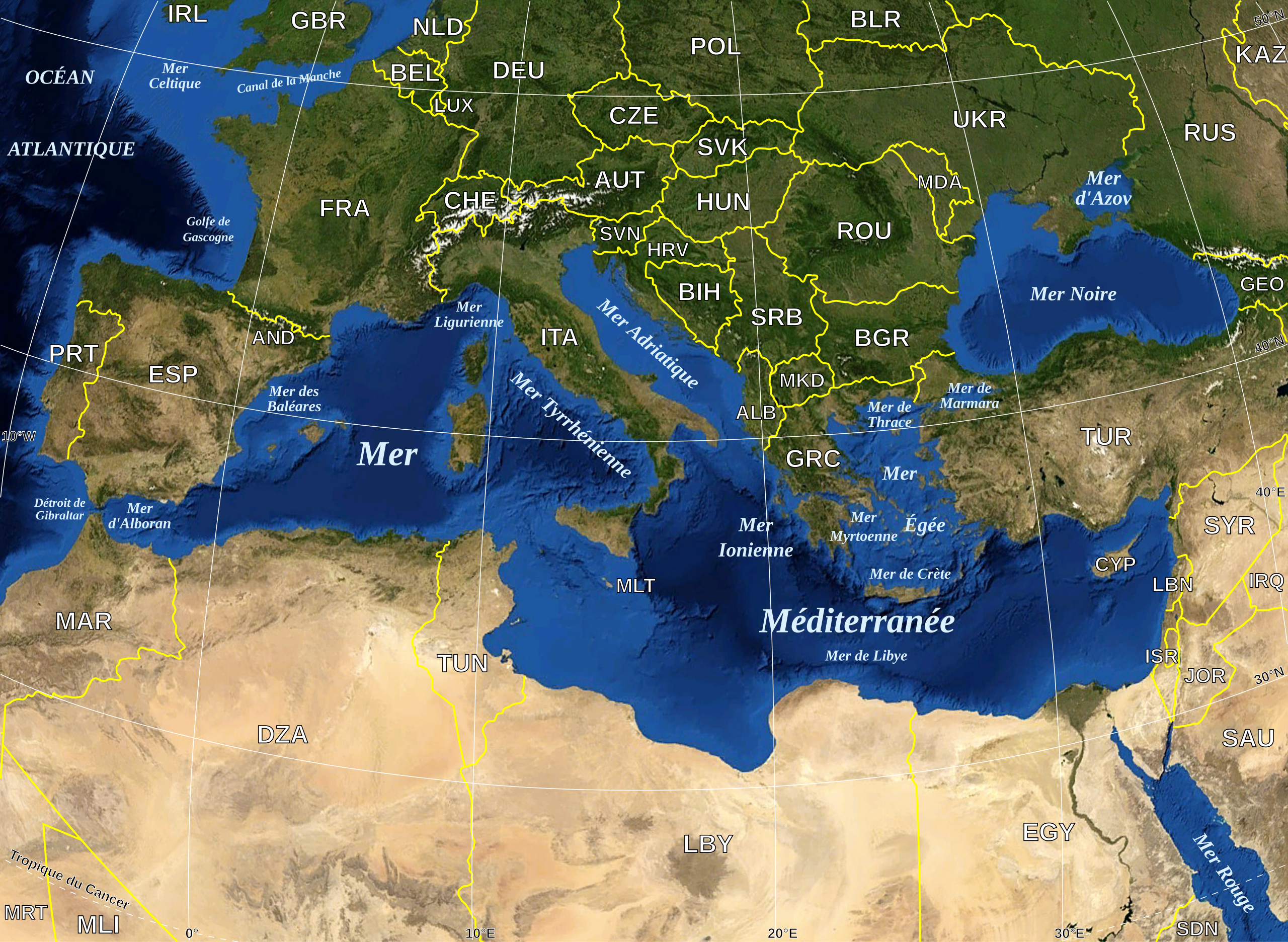
English: Map in French of the Mediterranean Sea, with the borders and the name of the States (except Montenegro, missing) following the ISO 3166-1 Alpha-3 code.
Français : Carte en français de la Mer Méditerranée avec les frontières et les noms des États (manque le Monténégro) suivant le code ISO 3166-1 Alpha-3.
Español: Mapa en francés del Mar Mediterráneo con las fronteras y los códigos de los Estados (menos el Montenegro) segun la norma ISO 3166-1 Alpha-3.
Deutsch: Karte des Mittelmeer, mit Staaten (bis auf Montenegro), ISO 3166-1 Alpha-3 code, und Grenzen, in französisch. |
| Date | |
| Source |
Own work ; Raster background map : screenshot from NASA World Wind (Public Domain) |
| Auteur | Eric Gaba (Sting - fr:Sting) |
| Autorisation (Réutilisation de ce fichier) |
All rights released |
| Autres versions |
|
| SVG information |


|
Ce fichier SVG contient du texte encapsulé pouvant facilement être traduit dans votre langue en utilisant n'importe quel éditeur de fichier SVG ou de texte, ou par l'outil de traduction de fichiers SVG. Pour plus d'informations, voir : A propos de la traduction des fichiers SVG. |
Conditions d’utilisation
| Cette image est dans le domaine public car elle est constituée d'une capture d'écran du logiciel World Wind de la NASA qui utilise des données du domaine public, comme Blue Marble, MODIS, Landsat, SRTM, USGS ou GLOBE.
|
 |
| This work was previously under Public Domain, or a Free License. It has been digitally enhanced and/or modified. This derivative work has been (or is hereby) released into the public domain by its author, Sting at the French Wikipedia project. This applies worldwide. In some countries this is not legally possible; if so:
|
Historique du fichier
Cliquer sur une date et heure pour voir le fichier tel qu'il était à ce moment-là.
| Date et heure | Vignette | Dimensions | Utilisateur | Commentaire | |
|---|---|---|---|---|---|
| actuel | 19 mai 2008 à 18:11 | | 2 046 × 1 496 (1,1 Mio) | Sting | "Tropic of Cancer" label correction |
| 21 juin 2007 à 02:56 |  | 2 046 × 1 496 (1,09 Mio) | Sting | {{Information |Description=Map in French of the Mediterranean Sea, with the borders and the name of the States following the ISO 3166-1 Alpha-3 code. |Source=Own work ;<br/>Background map : screenshot from NASA World Wind (Public |
Utilisation du fichier
Les 15 pages suivantes utilisent ce fichier :
- Cétacés de Méditerranée
- Liste des poissons de la mer Méditerranée
- Méduses de Méditerranée
- Nudibranches de Méditerranée
- Échinodermes de Méditerranée
- Utilisateur:Pradigue/Byrsa
- Wikipédia:Le Bistro/22 mars 2008
- Portail:Mer Méditerranée
- Portail:Mer Méditerranée/Index thématique
- Portail:Moyen-Orient
- Portail:Turquie
- Portail:Turquie/Portails connexes
- Projet:Moyen-Orient
- Projet:Moyen-Orient/Portails Connexes
- Projet:Moyen-Orient/Projets connexes
Usage global du fichier
Les autres wikis suivants utilisent ce fichier :
- Utilisation sur ar.wikipedia.org
- Utilisation sur fr.wiktionary.org