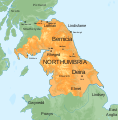
Fichier:Map of the Kingdom of Northumbria around 700 AD.svg

Taille de cet aperçu PNG pour ce fichier SVG : 586 × 594 pixels. Autres résolutions : 237 × 240 pixels | 474 × 480 pixels | 758 × 768 pixels | 1 010 × 1 024 pixels | 2 020 × 2 048 pixels.
Fichier d’origine (Fichier SVG, nominalement de 586 × 594 pixels, taille : 800 kio)
Historique du fichier
Cliquer sur une date et heure pour voir le fichier tel qu'il était à ce moment-là.
| Date et heure | Vignette | Dimensions | Utilisateur | Commentaire | |
|---|---|---|---|---|---|
| actuel | 30 novembre 2022 à 19:41 |  | 586 × 594 (800 kio) | Purplewowies | Reverted to version as of 22:26, 14 June 2019 (UTC) The new upload last month appears to have primarily been intended to change the serif font to sans serif but whatever was used to do it caused serious problems with how this looks--some of the labels are even unreadable |
| 23 octobre 2022 à 13:19 |  | 657 × 663 (392 kio) | Thingsomyipisntvisable | Main article: Edwin of Northumbria Edwin, like Æthelfrith, was king of both Deira and Bernicia and ruled them from 616 to 633. Under his reign the Isle of Man and the lands of Gwynedd in Northern Wales were incorporated into Northumbria. Edwin married Æthelburh, a Christian Princess from Kent in 625. He converted to Christianity two years later after a period of heavy consideration and after consulting numerous advisors.[48] Edwin fell in battle in 633 against Cadwallon of Gwynedd and the pag... | |
| 15 juin 2019 à 00:26 |  | 586 × 594 (800 kio) | Hogweard | =={{int:filedesc}}== {{Information |description={{en|1=Map of the Anglo-Saxon Kingdom of Northumbria around 700 AD}} |date=2019-06-14 |source={{f|Blank topographic map of the British Isles.svg}} *Derivative work: {{own}} |author={{u|Hogweard}} |permission= |other versions={{f|Map of the Anglo-Saxon Kingdom of Northumbria around 700 AD orange on green with labels.png}} }} =={{int:license-header}}== {{self|cc-by-sa-4.0}} Category:England Category:History of England [[Category:Scotland... |
Utilisation du fichier
Les 3 pages suivantes utilisent ce fichier :
Usage global du fichier
Les autres wikis suivants utilisent ce fichier :
- Utilisation sur en.wikipedia.org
- Utilisation sur fi.wikipedia.org
- Utilisation sur he.wikipedia.org
- Utilisation sur it.wikipedia.org
- Utilisation sur ko.wikipedia.org
- Utilisation sur mk.wikipedia.org
- Utilisation sur ru.wikipedia.org
- Utilisation sur sco.wikipedia.org
- Utilisation sur sv.wikipedia.org
- Utilisation sur uk.wikipedia.org
- Utilisation sur vi.wikipedia.org
- Utilisation sur zh.wikipedia.org

