Fichier:Map of Hven from copper etching of Blaeu Atlas 1663.jpg
Fichier d’origine (6 304 × 4 939 pixels, taille du fichier : 19,49 Mio, type MIME : image/jpeg)
Ce fichier et sa description proviennent de Wikimedia Commons.
| Description |
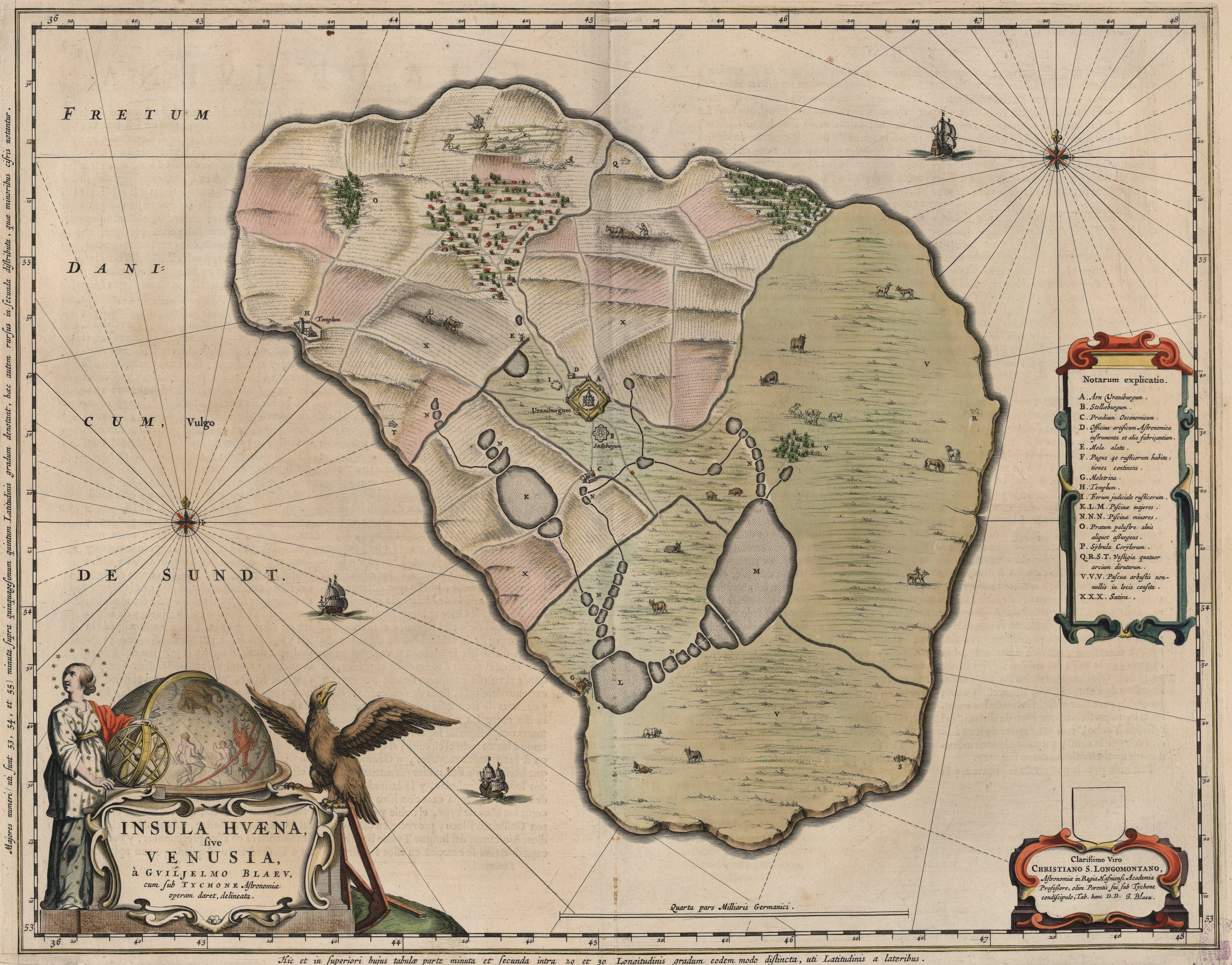
English: Map of the island of Hven from a copper etching of Willem Janszoon Blaeu's Blaeu Atlas 1663.
Willem made this map based on his experience as a student of Tycho Brahe between 1594 and 1596. On this map North is up, Denmark to the west and Scania, now part of Sweden, to the east. It shows the location of Uraniborg just above the centre, and below the linked set of ponds that Tycho had created to both collect water and power his papermill and other small industries on the island. Name of map : INSULAE HVAENA Map record source: Biblioteca Nacionale Espana (click on "View Digital object" to browse from the first page down to "GMG/189/177/mapa") (1664 is date of atlas on title page at "GMG/189/5/hg-ilustracionr") vorige upload: Tychobrahe.com
|
||||||||||||||||||||||||||
| Date | |||||||||||||||||||||||||||
| Source | (There is no permanent link) Browse to [1], click "View Digital Object", scroll down and click on link "GMG/189/177/mapa", image should appear named "GMG189177mapa.jpeg" in right hand panel. | ||||||||||||||||||||||||||
| Auteur |
|
||||||||||||||||||||||||||
.jpg)
|
Cette œuvre est également dans le domaine public dans tous les pays pour lesquels le droit d’auteur a une durée de vie de 100 ans ou moins après la mort de l’auteur. | |
| Ce fichier a été identifié comme étant exempt de restrictions connues liées au droit d’auteur, y compris tous les droits connexes et voisins. | |
| Annotations | Cette image est annotée : Voir les annotations sur Wikimedia Commons |


Historique du fichier
Cliquer sur une date et heure pour voir le fichier tel qu'il était à ce moment-là.
| Date et heure | Vignette | Dimensions | Utilisateur | Commentaire | |
|---|---|---|---|---|---|
| actuel | 9 août 2016 à 03:06 | | 6 304 × 4 939 (19,49 Mio) | Centpacrr | crp |
| 4 janvier 2013 à 13:46 |  | 7 598 × 6 341 (5,28 Mio) | Joop Rotte | ietwat hogere resolutie | |
| 30 décembre 2005 à 20:18 |  | 750 × 601 (89 kio) | Fred J | :: '' Originally uploaded on English Wikipedia by en:User:Wikibob. Map of the island of Hven from a copper etching of Willem Janszoon Blaeu's Blaeu Atlas 1663. Willem made this map while a student of Tycho Brahe between 1594 and 1596. On th |
Utilisation du fichier
La page suivante utilise ce fichier :
Usage global du fichier
Les autres wikis suivants utilisent ce fichier :
- Utilisation sur de.wikipedia.org
- Utilisation sur en.wikipedia.org
- Utilisation sur et.wikipedia.org
- Utilisation sur fa.wikipedia.org
- Utilisation sur ia.wikipedia.org
- Utilisation sur ja.wikipedia.org
- Utilisation sur ko.wikipedia.org
- Utilisation sur la.wikipedia.org
- Utilisation sur mk.wikipedia.org
- Utilisation sur nl.wikipedia.org
- Utilisation sur pl.wikipedia.org
- Utilisation sur ru.wikipedia.org
- Utilisation sur sv.wikipedia.org
- Utilisation sur uk.wikipedia.org
- Utilisation sur zh.wikipedia.org