Fichier:Manhattan Project US Map.png
Fichier d’origine (1 000 × 618 pixels, taille du fichier : 82 kio, type MIME : image/png)
Ce fichier et sa description proviennent de Wikimedia Commons.
Description

|
Une version vectorielle de cette image existe, dans le format « SVG ». Si elle n’est pas inférieure, elle devrait être utilisée à la place de la présente version pour des affichages en plus grandes dimensions ou nécessitant une meilleure résolution.
File:Manhattan Project US Map.png → File:Manhattan Project US Canada Map.svg
Pour plus d’informations sur les images vectorielles, consultez la page de transition de Commons vers le format SVG. Voir aussi les informations à propos de la manière dont le logiciel MediaWiki gère les images au format SVG. |
 |
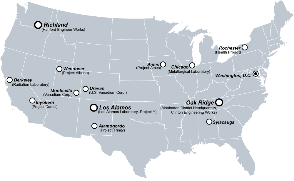
A selection of major United States sites in the Manhattan Project.
Created by Fastfission in Adobe Illustrator.
Conditions d’utilisation
| Cette œuvre a été placée dans le domaine public par son auteur, Fastfission. Ceci s’applique dans le monde entier. Dans certains pays, ceci peut ne pas être possible ; dans ce cas : |
If you want to credit someone, credit "Wikimedia Commons." Otherwise don't credit anyone, that's fine by me. --Fastfission 15:01, 14 April 2008 (UTC)
Upload history at other wikipedias
- WP:EN
- 20:52, 11 Dec 2004 . . Fastfission (44787 bytes) (Major United States sites in the Manhattan Project. Created by User:Fastfission in Adobe Illustrator)
Historique du fichier
Cliquer sur une date et heure pour voir le fichier tel qu'il était à ce moment-là.
| Date et heure | Vignette | Dimensions | Utilisateur | Commentaire | |
|---|---|---|---|---|---|
| actuel | 10 mars 2011 à 00:29 | | 1 000 × 618 (82 kio) | Hawkeye7 | Ooops! Accidentally map it smaller |
| 9 mars 2011 à 11:36 |  | 600 × 371 (113 kio) | Hawkeye7 | Removed spelling error | |
| 20 août 2005 à 21:01 |  | 1 000 × 618 (44 kio) | Dake~commonswiki | A selection of major United States sites in the Manhattan Project. Created by en:User:Fastfission in Adobe Illustrator. {{GFDL}} Category:U.S. history images | |
| 20 janvier 2005 à 23:13 |  | 1 000 × 618 (44 kio) | Get It | will add info after upload |
Utilisation du fichier
La page suivante utilise ce fichier :
Usage global du fichier
Les autres wikis suivants utilisent ce fichier :
- Utilisation sur ast.wikipedia.org
- Utilisation sur ca.wikipedia.org
- Utilisation sur en.wikipedia.org
- Utilisation sur eo.wikipedia.org
- Utilisation sur id.wikipedia.org
- Utilisation sur it.wikipedia.org
- Utilisation sur ka.wikipedia.org
- Utilisation sur lt.wikipedia.org
- Utilisation sur pt.wikipedia.org
- Utilisation sur ru.wikipedia.org
- Utilisation sur sc.wikipedia.org
- Utilisation sur sk.wikipedia.org