Fichier:Location Tumen-River.png
Pas de plus haute résolution disponible.
Location_Tumen-River.png (489 × 337 pixels, taille du fichier : 111 kio, type MIME : image/png)
Ce fichier et sa description proviennent de Wikimedia Commons.
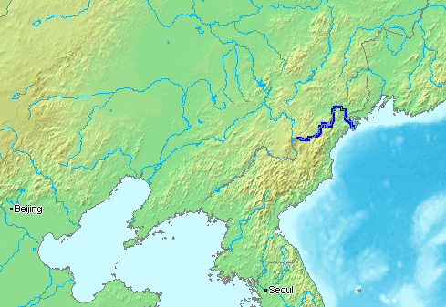
English: The Tumen River is a long river that serves as part of the boundary between China, North Korea, and the Russian Federation.
- Русский: ru:Туманная (река) - река на Дальнем Востоке, по которой проходят границы России, КНДР и Китая.
This image is in the public domain because it came from the site https://www.demis.nl/products/web-map-server/examples/ and was released by the copyright holder. Permission is granted to copy, distribute and/or modify this map since it is based on free of copyright images from: www.demis.nl. See also approval email on de.wp and its clarification.
|
| This work has been released into the public domain by its copyright holder, www.demis.nl. This applies worldwide. Dans certains pays, ceci peut ne pas être possible ; dans ce cas : www.demis.nl accorde à toute personne le droit d’utiliser cette œuvre dans n’importe quel but, sans aucune condition, sauf celles requises par la loi.
|
Historique du fichier
Cliquer sur une date et heure pour voir le fichier tel qu'il était à ce moment-là.
| Date et heure | Vignette | Dimensions | Utilisateur | Commentaire | |
|---|---|---|---|---|---|
| actuel | 13 janvier 2007 à 17:16 | | 489 × 337 (111 kio) | Kaba | en:Tumen River is a long river that serves as part of the boundary between en:China, en:North Korea, and the [:en:Russian Federation|]]. ja:豆満江はは中朝国境のja:白頭山に源流を発し、ja:中国、[[:ja |
Utilisation du fichier
Les 2 pages suivantes utilisent ce fichier :
Usage global du fichier
Les autres wikis suivants utilisent ce fichier :
- Utilisation sur af.wikipedia.org
- Utilisation sur ar.wikipedia.org
- Utilisation sur azb.wikipedia.org
- Utilisation sur bn.wikipedia.org
- Utilisation sur br.wikipedia.org
- Utilisation sur ckb.wikipedia.org
- Utilisation sur cs.wikipedia.org
- Utilisation sur de.wikipedia.org
- Utilisation sur en.wikipedia.org
- Utilisation sur en.wikinews.org
- Utilisation sur es.wikipedia.org
- Utilisation sur fa.wikipedia.org
- Utilisation sur fi.wikipedia.org
- Utilisation sur fi.wikinews.org
- Utilisation sur he.wikipedia.org
- Utilisation sur hi.wikipedia.org
- Utilisation sur hu.wikipedia.org
- Utilisation sur id.wikipedia.org
- Utilisation sur it.wikipedia.org
- Utilisation sur ja.wikipedia.org
- Utilisation sur jv.wikipedia.org
- Utilisation sur ko.wikipedia.org
- Utilisation sur mk.wikipedia.org
- Utilisation sur ml.wikipedia.org
- Utilisation sur mn.wikipedia.org
- Utilisation sur nl.wikipedia.org
- Utilisation sur nn.wikipedia.org
- Utilisation sur no.wikipedia.org
- Utilisation sur oc.wikipedia.org
- Utilisation sur pa.wikipedia.org
- Utilisation sur pl.wikipedia.org
- Utilisation sur pnb.wikipedia.org
- Utilisation sur pt.wikipedia.org
- Utilisation sur ru.wikipedia.org
- Utilisation sur sh.wikipedia.org
- Utilisation sur sv.wikipedia.org
- Utilisation sur th.wikipedia.org
- Utilisation sur vi.wikipedia.org
- Utilisation sur zh-min-nan.wikipedia.org
- Utilisation sur zh-yue.wikipedia.org
- Utilisation sur zh.wikipedia.org