Fichier:Le Mont St. Michel, Normandy, France. View, bilingual description and map.jpg

Taille de cet aperçu : 800 × 596 pixels. Autres résolutions : 320 × 238 pixels | 640 × 477 pixels | 1 024 × 763 pixels | 1 280 × 953 pixels | 2 560 × 1 907 pixels | 3 797 × 2 828 pixels.
Fichier d’origine (3 797 × 2 828 pixels, taille du fichier : 3,11 Mio, type MIME : image/jpeg)
Ce fichier et sa description proviennent de Wikimedia Commons.
Description
| Description |
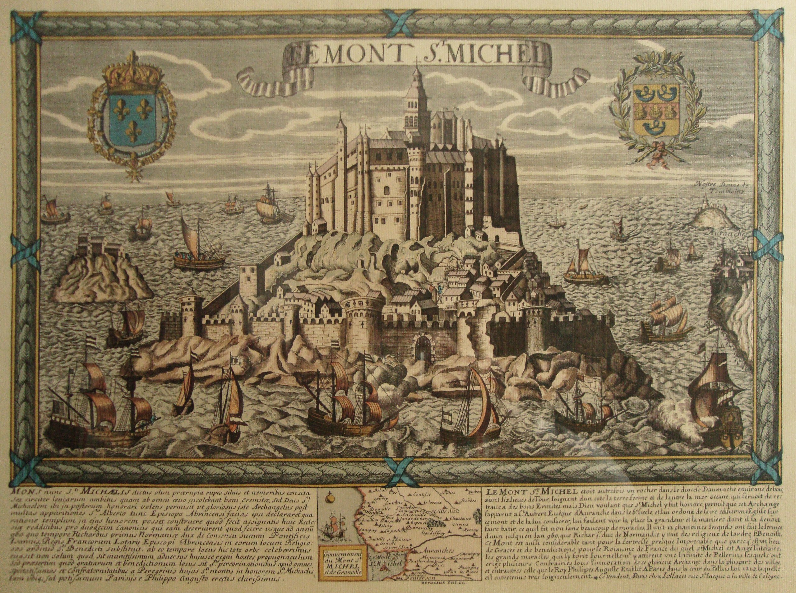
English: Le Mont St. Michel, Normandy, France. It is a map (date between late XVIII and early XIX centuries; personal library) that comprises an old view, with a bilingual historical description, of the place (Latin and French) and map. Made by Daniel Louis Derveaux (1914-2010). Although the images collected at http://en.wikipedia.org/wiki/Mont_Saint-Michel#Development suggest that this engraving is wrong due to the central and higher tower, which is represented in its actual shape in the maquette corresponding to the XX century, resembles to the present one, but not to that represented in the maquette corresponding to XVII-XVIII centuries, this engraving has to be dated so far to the last days of the monarchy in the late XVIII century, or during the brief Bourbon restoration of XIX century, due to the Royal Coat of Arms of the Kingdom of France, at the left upper corner of the engraving. Also, the image at http://www.vintage-maps.com/en/Antique-Maps/Europe/France/Merian-France-Mont-Saint-Michel-1657::401.html?XTCsid=2204da727b878fd7bc48a0c7a424cb01, which correspond to a view of the XVII century, shows the same same central and higher tower in the shape that has this uploaded image, instead of resembling that of the maquette 3, corresponding to XVII-XVIII centuries. Typographical characters suggest XVIII century.
Español: El Monte San Miguel, en Normandía, Francia. Se trata de un mapa, datable a fines del s. XVIII o a principios del s. XIX, que reune en una pieza la vista del sitio, su descripción histórica bilingüe (latín y francés), y un mapa propiamente dicho. Hecho por Daniel Louis Derveaux (1914-2010). Aunque las imágenes reunidas en http://en.wikipedia.org/wiki/Mont_Saint-Michel#Development sugieren que este grabado es apócrifo, debido a que la torre central, más alta, que es representada en su forma presente en la maqueta que corresponde al siglo XX, se asemeja a la de esta imagen, pero no a aquella representada en la maqueta que corresponde a los siglos XVII-XVIII, este grabado debería ser datado a más tardar fines del s. XVIII o, cuanto más reciente, a principios del s. XIX, por razón del escudo de armas real en la esquina superior izquierda. Además, la imagen en http://www.vintage-maps.com/en/Antique-Maps/Europe/France/Merian-France-Mont-Saint-Michel-1657::401.html?XTCsid=2204da727b878fd7bc48a0c7a424cb01 muestra la misma torre central en la figura que tiene en esta imagen, en lugar de la forma sugerida por la recreación de la maqueta 3, correspondiente a los ss. XVII-XVIII. La tipografía sugiere que es del s. XVIII. |
| Date | Without date: late XVIII century or early XIX century. Typographical characters suggest XVIII century. / Sin fecha: datable a fines del s. XVIII o a principios del s. XIX. La tipografía sugiere que es del s. XVIII. |
| Source | Travail personnel;just for the photograph; it is an antique work./Trabajo propio en lo que concierne a la fotografía, pues la obra retratada es antigua. |
| Auteur | Rhurtadon; but just for the photograph. Te map it self seems to be made by some Deracaux./ La obra en sí misma fue hecha por cierto Deracaux. |
| Autorisation (Réutilisation de ce fichier) |
All granted. / Todos concedidos. |
| Lieu de la prise de vue | | Voir cet endroit et d’autres images sur : OpenStreetMap |
|---|
Conditions d’utilisation
Moi, en tant que détenteur des droits d’auteur sur cette œuvre, je la publie sous les licences suivantes :

|
Vous avez la permission de copier, distribuer et modifier ce document selon les termes de la GNU Free Documentation License version 1.2 ou toute version ultérieure publiée par la Free Software Foundation, sans sections inaltérables, sans texte de première page de couverture et sans texte de dernière page de couverture. Un exemplaire de la licence est inclus dans la section intitulée GNU Free Documentation License. |
This file is licensed under the Creative Commons Attribution-Share Alike 4.0 International, 3.0 Unported, 2.5 Generic, 2.0 Generic and 1.0 Generic license.
- Vous êtes libre :
- de partager – de copier, distribuer et transmettre cette œuvre
- d’adapter – de modifier cette œuvre
- Sous les conditions suivantes :
- paternité – Vous devez donner les informations appropriées concernant l'auteur, fournir un lien vers la licence et indiquer si des modifications ont été faites. Vous pouvez faire cela par tout moyen raisonnable, mais en aucune façon suggérant que l’auteur vous soutient ou approuve l’utilisation que vous en faites.
- partage à l’identique – Si vous modifiez, transformez, ou vous basez sur cette œuvre, vous devez distribuer votre contribution sous la même licence ou une licence compatible avec celle de l’original.
Vous pouvez choisir l’une de ces licences.
Historique du fichier
Cliquer sur une date et heure pour voir le fichier tel qu'il était à ce moment-là.
| Date et heure | Vignette | Dimensions | Utilisateur | Commentaire | |
|---|---|---|---|---|---|
| actuel | 28 février 2014 à 10:22 | | 3 797 × 2 828 (3,11 Mio) | MartinoK | Lens correction, colour cleansing, undistorted and rotated. |
| 11 mai 2010 à 05:06 |  | 4 000 × 3 000 (4,12 Mio) | Rhurtadon | {{Information |Description={{en|1=Le Mont St. Michel, Normandy, France. It is a map (date between late XVIII and early XIX centuries) that comprises an old view, with a bilingual description, of the place (Latin and French) and map. Made by some Deracaux. |
Utilisation du fichier
Les 2 pages suivantes utilisent ce fichier :
Usage global du fichier
Les autres wikis suivants utilisent ce fichier :
- Utilisation sur ca.wikipedia.org
- Utilisation sur es.wikipedia.org
- Utilisation sur uk.wikipedia.org