Fichier:Københavns Hovedbanegård - Copenhagen Central Station (37896979131).jpg

Fichier d’origine (5 708 × 3 893 pixels, taille du fichier : 5,24 Mio, type MIME : image/jpeg)
Ce fichier et sa description proviennent de Wikimedia Commons.
.jpg?uselang=fr)
Description
| Description |
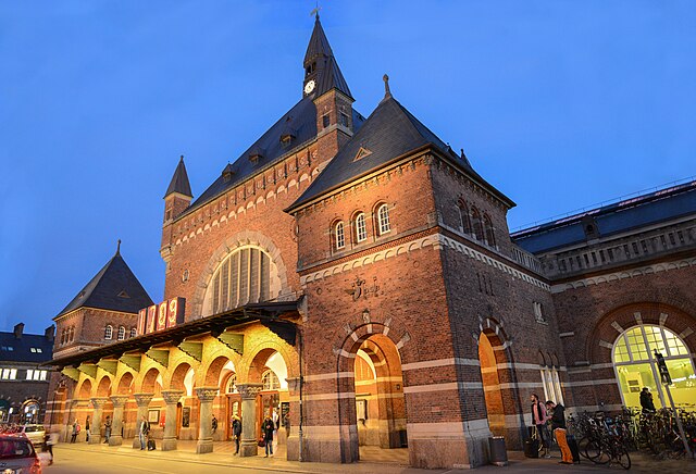
English: Copenhagen Central Station (Danish: Københavns Hovedbanegård, abbreviated København H) is the main railway station in Copenhagen, Denmark and the largest railway station in Denmark, although Nørreport Station has a larger passenger throughput if urban S-train and Metro services are included. It is situated between the districts of Indre By and Vesterbro with entrances from Bernstorffsgade (at Tivoli Gardens), Banegårdspladsen, Reventlowsgade and access to platforms from Tietgensgade.
The main hall isn't just a waiting hall, but also a market place where most things can be bought. From fresh fruit sellers to super market, postal office, banks, currency exchanges, hamburgers, coffee shops, restaurants and pubs etc. There are also travel center for information and manual sale of tickets and two large toilet sections which are under manual supervision and clean. Shower rooms are also available for a smaller fee. The current station building opened in 1911 and is the work of architect Heinrich Wenck. The station has 7 platforms and 13 tracks. On the station concourse there are many small shops, cafeterias, and fast food outlets. All public transport within Greater Copenhagen are divided into close to 100 ticket fare zones. The Central station is located in fare zone 1, which together with zones 2 and 3 constitute Copenhagen municipality and the "exclave" of Frederiksberg municipality. As the cheapest single ticket always is valid in two zones, a single ticket bought at the station is valid within the entire city centre and its inner boroughs. A ticket to Copenhagen Airport Kastrup, however, demands the payment for three zones since it is located in zone 4 [Wikipedia.org] |
| Date | |
| Source | Københavns Hovedbanegård - Copenhagen Central Station |
| Auteur | Jorge Láscar from Melbourne, Australia |
| Lieu de la prise de vue | | Voir cet endroit et d’autres images sur : OpenStreetMap |
|---|
.jpg¶ms=055.673138_N_0012.563822_E_globe:Earth_type:camera_source:Flickr_&language=fr)
Conditions d’utilisation
- Vous êtes libre :
- de partager – de copier, distribuer et transmettre cette œuvre
- d’adapter – de modifier cette œuvre
- Sous les conditions suivantes :
- paternité – Vous devez donner les informations appropriées concernant l'auteur, fournir un lien vers la licence et indiquer si des modifications ont été faites. Vous pouvez faire cela par tout moyen raisonnable, mais en aucune façon suggérant que l’auteur vous soutient ou approuve l’utilisation que vous en faites.
| Cette image a été originellement postée sur Flickr par Jorge Lascar à l'adresse https://flickr.com/photos/8721758@N06/37896979131 (archives). Elle a été passée en revue le 8 février 2018 par le robot FlickreviewR 2, qui a confirmé qu'elle se trouvait sous licence cc-by-2.0. |
Historique du fichier
Cliquer sur une date et heure pour voir le fichier tel qu'il était à ce moment-là.
| Date et heure | Vignette | Dimensions | Utilisateur | Commentaire | |
|---|---|---|---|---|---|
| actuel | 8 février 2018 à 11:19 | | 5 708 × 3 893 (5,24 Mio) | Thesupermat2 | Transferred from Flickr via Flickr2Commons |
Utilisation du fichier
Les 2 pages suivantes utilisent ce fichier :
Usage global du fichier
Les autres wikis suivants utilisent ce fichier :
- Utilisation sur en.wikipedia.org
.jpg)