Fichier:Joggins Cliffs, Nova Scotia.jpg

Taille de cet aperçu : 600 × 600 pixels. Autres résolutions : 240 × 240 pixels | 480 × 480 pixels | 768 × 768 pixels | 1 024 × 1 024 pixels | 2 048 × 2 048 pixels | 3 000 × 3 000 pixels.
Fichier d’origine (3 000 × 3 000 pixels, taille du fichier : 4,64 Mio, type MIME : image/jpeg)
Ce fichier et sa description proviennent de Wikimedia Commons.
Description
| Description |
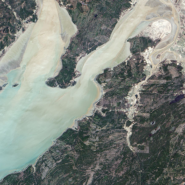
English: The Advanced Land Imager (ALI) on NASA’s Earth Observing-1 satellite captured this true-color image of the Joggins Fossil Cliffs region. The fossil cliffs trace a curving line through the middle of this image, with Cumberland Basin in the west and a small village in the east. Sunlight and sediment color the water of Cumberland Basin pastel. On land, colors vary from deep green vegetation to brown bare rock to gray paved surfaces. Roads cut crooked lines through the landscape. The cliffs appear gray-beige, giving way to buff color nearest the water. |
| Date | |
| Source | NASA Earth Observatory |
| Auteur | Jesse Allen |
Instrument: EO-1 - ALI
Conditions d’utilisation
| Ce fichier provient de la NASA. Sauf exception, les documents créés par la NASA ne sont pas soumis à copyright. Pour plus d'informations, voir la politique de copyright de la NASA. | ||
 |
Attention :
|
| Annotations | Cette image est annotée : Voir les annotations sur Wikimedia Commons |
Historique du fichier
Cliquer sur une date et heure pour voir le fichier tel qu'il était à ce moment-là.
| Date et heure | Vignette | Dimensions | Utilisateur | Commentaire | |
|---|---|---|---|---|---|
| actuel | 23 mai 2009 à 15:53 | | 3 000 × 3 000 (4,64 Mio) | Originalwana | {{Information |Description={{en|1=The Advanced Land Imager (ALI) on NASA’s Earth Observing-1 satellite captured this true-color image of the Joggins Fossil Cliffs region. The fossil cliffs trace a curving line through the middle of this image, with Cumb |
Utilisation du fichier
Les 3 pages suivantes utilisent ce fichier :
Usage global du fichier
Les autres wikis suivants utilisent ce fichier :
- Utilisation sur de.wikipedia.org
- Utilisation sur en.wikipedia.org
- Utilisation sur hr.wikipedia.org
- Utilisation sur ru.wikipedia.org
- Utilisation sur sh.wikipedia.org
- Utilisation sur uk.wikipedia.org