Fichier:Islam in Netherlands.jpg
Taille de cet aperçu : 515 × 599 pixels. Autres résolutions : 206 × 240 pixels | 412 × 480 pixels | 660 × 768 pixels | 1 027 × 1 195 pixels.
Fichier d’origine (1 027 × 1 195 pixels, taille du fichier : 264 kio, type MIME : image/jpeg)
Ce fichier et sa description proviennent de Wikimedia Commons.
| Description |
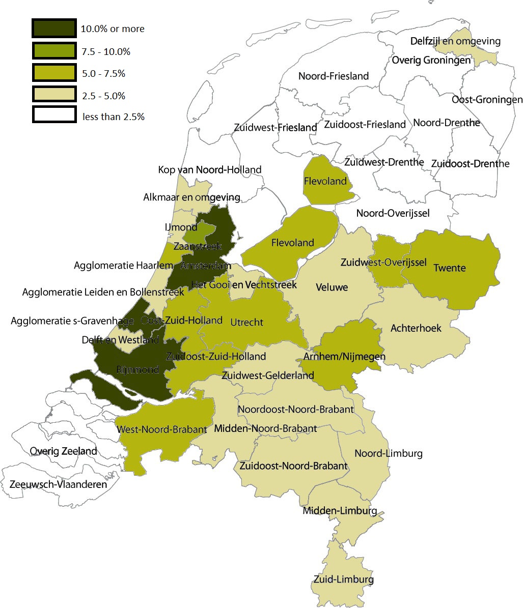
English: Share of Muslims per COROP area, 1 January 2004 . Data are from Statistics Netherlands (this Statline table); note that Statistics Netherlands calculated the number of muslims by adding up all persons by country of 'origin'. That method changed in 2006, allowing for a more accurate measuring of actual muslims; see this CBS webpage. |
| Date | (UTC) |
| Source | |
| Auteur |
|
| Cette image a été retouchée, ce qui signifie qu'elle a été modifiée par ordinateur et est différente de l'image d'origine. Liste des modifications : Share of Muslims per COROP area, 1 January 2004. L'image d'origine se trouve ici : Coropgebieden plain.png:
|
Moi, en tant que détenteur des droits d’auteur sur cette œuvre, je la publie sous la licence suivante :
| Ce fichier est disponible selon les termes de la licence Creative Commons CC0 Don universel au domaine public. | |
| La personne qui a associé une œuvre avec cet acte l’a placée dans le domaine public en renonçant mondialement à tous ses droits sur cette œuvre en vertu des lois relatives au droit d’auteur, ainsi qu’à tous les droits juridiques connexes et voisins qu’elle possédait sur l’œuvre, sans autre limite que celles imposées par la loi. Vous pouvez copier, modifier, distribuer et utiliser cette œuvre, y compris à des fins commerciales, sans qu’il soit nécessaire d’en demander la permission.
|
Journal des téléversements d’origine
This image is a derivative work of the following images:
- File:Coropgebieden_plain.png licensed with Cc-zero
- 2010-07-28T16:31:25Z Classical geographer 1027x1195 (213857 Bytes) Without border.
- 2010-07-28T16:30:11Z Classical geographer 1102x1300 (215966 Bytes) B&W and with more readable labels.
- 2009-07-09T11:31:36Z Classical geographer 1199x1407 (554327 Bytes) [[Category:Maps of the Netherlands]] [[Category:Statistical divisions]]
- 2009-07-09T11:30:29Z Classical geographer 3588x3529 (566115 Bytes) {{Information |Description={{en|1=Map of the Dutch NUTS3 regions (COROP regions). Made using GIS software.}} |Source=Own work by uploader |Author=[[User:Classical geographer|Classical geographer]] |Date=2009-07-09 |Permission
Téléversé avec derivativeFX
Historique du fichier
Cliquer sur une date et heure pour voir le fichier tel qu'il était à ce moment-là.
| Date et heure | Vignette | Dimensions | Utilisateur | Commentaire | |
|---|---|---|---|---|---|
| actuel | 6 janvier 2011 à 07:05 | | 1 027 × 1 195 (264 kio) | Giornorosso | {{Information |Description={{en|1=Map of the Dutch NUTS3 regions (COROP regions). Made using GIS software.}} |Source=*File:Coropgebieden_plain.png |Date=2011-01-06 05:02 (UTC) |Author=*File:Coropgebieden_plain.png: [[User:Classical geographer| |
Utilisation du fichier
La page suivante utilise ce fichier :
Usage global du fichier
Les autres wikis suivants utilisent ce fichier :
- Utilisation sur ar.wikipedia.org
- Utilisation sur bn.wikipedia.org
- Utilisation sur tt.wikipedia.org