Fichier:First Republic of Armenia in 1918-1920.png

Taille de cet aperçu : 799 × 348 pixels. Autres résolutions : 320 × 139 pixels | 640 × 279 pixels | 1 024 × 446 pixels | 1 280 × 558 pixels | 2 560 × 1 115 pixels | 8 192 × 3 568 pixels.
Fichier d’origine (8 192 × 3 568 pixels, taille du fichier : 14,85 Mio, type MIME : image/png)
Ce fichier et sa description proviennent de Wikimedia Commons.
Description
| Description |
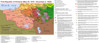
English: The First Republic of Armenia in 1918-1920. |
| Date | |
| Source | Travail personnel |
| Auteur | Accipite7 |
Conditions d’utilisation
Moi, en tant que détenteur des droits d’auteur sur cette œuvre, je la publie sous la licence suivante :
Ce fichier est sous la licence Creative Commons Attribution – Partage dans les Mêmes Conditions 4.0 International.
- Vous êtes libre :
- de partager – de copier, distribuer et transmettre cette œuvre
- d’adapter – de modifier cette œuvre
- Sous les conditions suivantes :
- paternité – Vous devez donner les informations appropriées concernant l'auteur, fournir un lien vers la licence et indiquer si des modifications ont été faites. Vous pouvez faire cela par tout moyen raisonnable, mais en aucune façon suggérant que l’auteur vous soutient ou approuve l’utilisation que vous en faites.
- partage à l’identique – Si vous modifiez, transformez, ou vous basez sur cette œuvre, vous devez distribuer votre contribution sous la même licence ou une licence compatible avec celle de l’original.
Historique du fichier
Cliquer sur une date et heure pour voir le fichier tel qu'il était à ce moment-là.
| Date et heure | Vignette | Dimensions | Utilisateur | Commentaire | |
|---|---|---|---|---|---|
| actuel | 2 juin 2021 à 17:13 | | 8 192 × 3 568 (14,85 Mio) | Accipite7 | for the convenience of viewing small details, the size is increased, the colors are improved |
| 25 mai 2021 à 10:17 |  | 4 096 × 1 784 (3,69 Mio) | Accipite7 | The border between Nahang of Shirak and Nahang of Syunik has been clarified. | |
| 21 mai 2021 à 11:59 |  | 4 096 × 1 784 (3,7 Mio) | Accipite7 | The temporary border between the Republic of Armenia and the Soviet republics (August 10, 1920) in the Nakhichevan county has been clarified. Added a legend marked on the map under the number 26. | |
| 13 mai 2021 à 10:35 |  | 4 096 × 1 784 (3,97 Mio) | Accipite7 | fixed typo | |
| 13 mai 2021 à 10:27 |  | 4 096 × 1 784 (3,97 Mio) | Accipite7 | The names of the types of administrative units of the former Russian Empire have been clarified: uyezd = county, okrug = district, oblast = territory, guberniya = governorate. | |
| 12 mai 2021 à 13:14 |  | 4 096 × 1 784 (3,71 Mio) | Accipite7 | Corrected data in the map legend regarding what is indicated on the map by numbers. Clarified the boundaries of the territories required at the Paris Peace Conference. I strongly ask the user of Culminatio not to vandalize and not return the map to the version on which he marked the line reached as a result of the Turkish offensive in 1920. Since, firstly, it is neural: Batumi, Artvin and Ardahan were under the control of the Democratic Republic of Georgia until February-March 1921. And secon... | |
| 12 mai 2021 à 06:13 |  | 5 375 × 2 341 (7,18 Mio) | Culminatio | Reverted to version as of 15:05, 8 May 2021 (UTC) | |
| 11 mai 2021 à 09:11 |  | 4 096 × 1 784 (3,99 Mio) | Accipite7 | The boundaries of the territory of the demands of the Armenian delegation in the Transcaucasus, submitted to the Paris Peace Conference of 1919, were clarified. There is no need to overload the map with the line reached by the Turkish forces in 1920, as the map already shows the results of the Armenian-Turkish war of 1920 - the border according to the Treaty of Alexandropol, December 2, 1920 | |
| 8 mai 2021 à 17:05 |  | 5 375 × 2 341 (7,18 Mio) | Culminatio | Additional line of the turkish advance on the northern positions during the war of 1920. Additional numbers 10,19,20,21 on the map. | |
| 8 mai 2021 à 12:49 |  | 6 336 × 2 760 (2,21 Mio) | Accipite7 | Improved colors. |
Utilisation du fichier
La page suivante utilise ce fichier :
Usage global du fichier
Les autres wikis suivants utilisent ce fichier :
- Utilisation sur az.wikipedia.org
- Utilisation sur be.wikipedia.org
- Utilisation sur bg.wikipedia.org
- Utilisation sur de.wikipedia.org
- Utilisation sur el.wikipedia.org
- Utilisation sur fi.wikipedia.org
- Utilisation sur hy.wikipedia.org
- Utilisation sur it.wikipedia.org
- Utilisation sur nl.wikipedia.org
- Utilisation sur pl.wikipedia.org
- Utilisation sur pt.wikipedia.org
- Utilisation sur ro.wikipedia.org
- Utilisation sur ru.wikipedia.org
- Utilisation sur sr.wikipedia.org
- Utilisation sur uk.wikipedia.org
- Utilisation sur zh.wikipedia.org