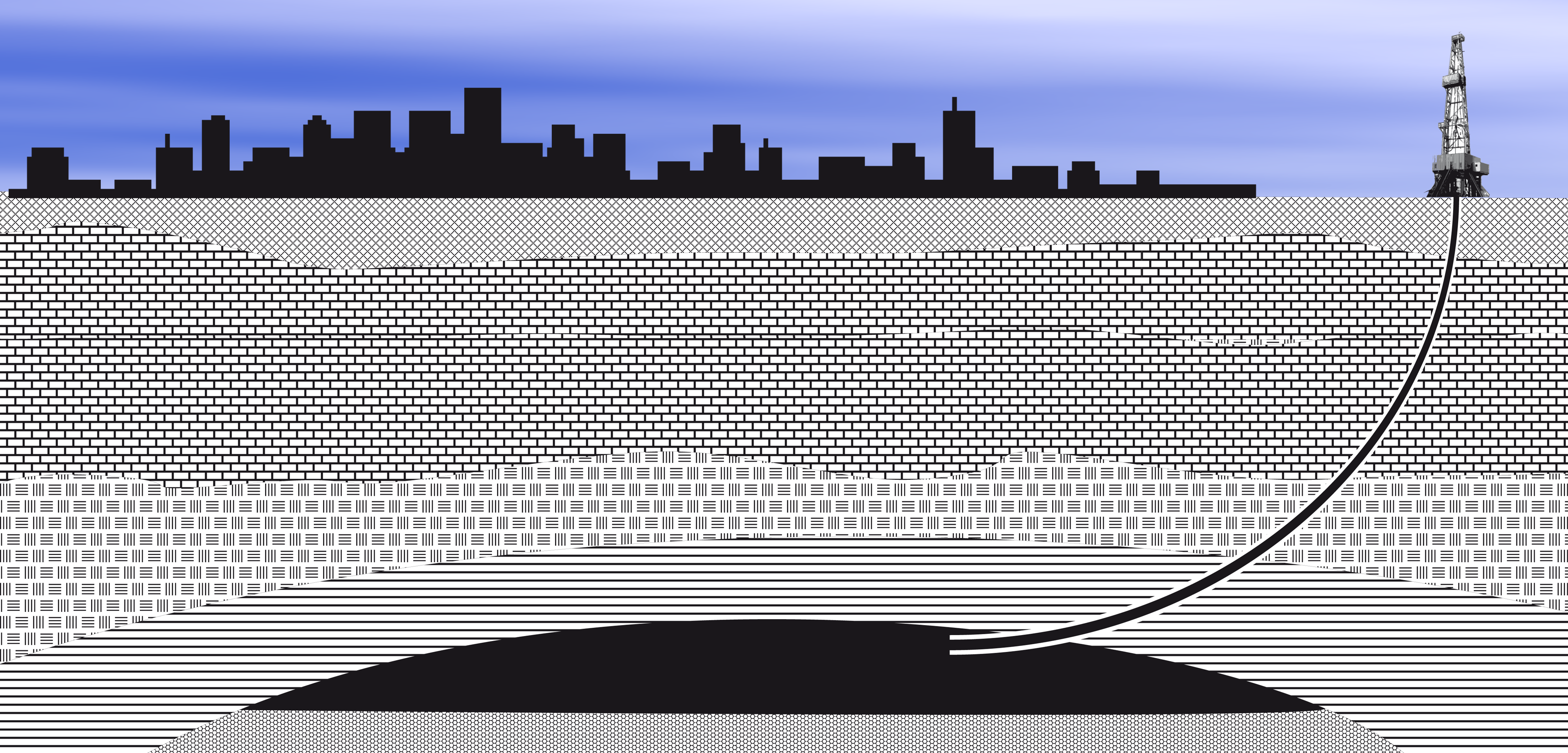
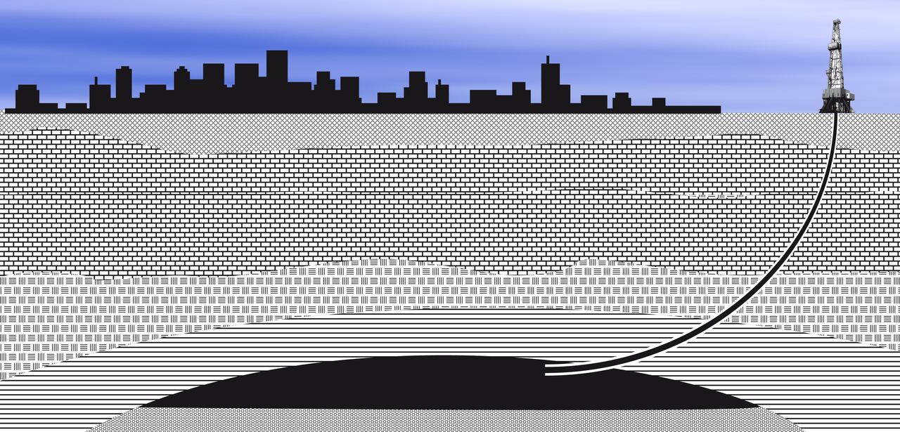
Fichier:Directional well under city.png
Taille de cet aperçu : 800 × 385 pixels. Autres résolutions : 320 × 154 pixels | 640 × 308 pixels | 1 024 × 492 pixels | 1 280 × 615 pixels | 3 441 × 1 654 pixels.
Fichier d’origine (3 441 × 1 654 pixels, taille du fichier : 1,35 Mio, type MIME : image/png)
Ce fichier et sa description proviennent de Wikimedia Commons.

|
Une version vectorielle de cette image existe, dans le format « SVG ». Si elle n’est pas inférieure, elle devrait être utilisée à la place de la présente version pour des affichages en plus grandes dimensions ou nécessitant une meilleure résolution.
File:Directional well under city.png → File:Directional well under city.svg
Pour plus d’informations sur les images vectorielles, consultez la page de transition de Commons vers le format SVG. Voir aussi les informations à propos de la manière dont le logiciel MediaWiki gère les images au format SVG. |
 |
Description
| Description |
Deutsch: Richtbohrung unter eine Stadt - Schematische Darstellung
English: Directional well under city - diagram
Polski: Otwór kierunkowy pod miastem - schemat |
| Date | |
| Source | Travail personnel |
| Auteur | SebaeL |
Conditions d’utilisation
Moi, en tant que détenteur des droits d’auteur sur cette œuvre, je la publie sous les licences suivantes :

|
Vous avez la permission de copier, distribuer et modifier ce document selon les termes de la GNU Free Documentation License version 1.2 ou toute version ultérieure publiée par la Free Software Foundation, sans sections inaltérables, sans texte de première page de couverture et sans texte de dernière page de couverture. Un exemplaire de la licence est inclus dans la section intitulée GNU Free Documentation License. |
This file is licensed under the Creative Commons Attribution-Share Alike 4.0 International, 3.0 Unported, 2.5 Generic, 2.0 Generic and 1.0 Generic license.
- Vous êtes libre :
- de partager – de copier, distribuer et transmettre cette œuvre
- d’adapter – de modifier cette œuvre
- Sous les conditions suivantes :
- paternité – Vous devez donner les informations appropriées concernant l'auteur, fournir un lien vers la licence et indiquer si des modifications ont été faites. Vous pouvez faire cela par tout moyen raisonnable, mais en aucune façon suggérant que l’auteur vous soutient ou approuve l’utilisation que vous en faites.
- partage à l’identique – Si vous modifiez, transformez, ou vous basez sur cette œuvre, vous devez distribuer votre contribution sous la même licence ou une licence compatible avec celle de l’original.
Vous pouvez choisir l’une de ces licences.
Historique du fichier
Cliquer sur une date et heure pour voir le fichier tel qu'il était à ce moment-là.
| Date et heure | Vignette | Dimensions | Utilisateur | Commentaire | |
|---|---|---|---|---|---|
| actuel | 13 novembre 2009 à 23:18 | | 3 441 × 1 654 (1,35 Mio) | SebaeL | Reverted to version as of 21:03, 13 November 2009 |
| 13 novembre 2009 à 23:18 |  | 3 441 × 1 654 (440 kio) | SebaeL | Reverted to version as of 21:36, 19 June 2009 | |
| 13 novembre 2009 à 23:03 |  | 3 441 × 1 654 (1,35 Mio) | SebaeL | Kosmetyczne | |
| 19 juin 2009 à 23:36 |  | 3 441 × 1 654 (440 kio) | SebaeL | {{Information |Description={{en|1=Directional well under city - diagram}} {{pl|1=Otwór kierunkowy pod miastem - schemat}} |Source=Praca własna osoby przesyłającej (own work by uploader) |Author=SebaeL |Date=2009-06-19 |Permission= |oth |
Utilisation du fichier
La page suivante utilise ce fichier :
Usage global du fichier
Les autres wikis suivants utilisent ce fichier :
- Utilisation sur ar.wikipedia.org
- Utilisation sur de.wikipedia.org
- Utilisation sur en.wikiversity.org