Fichier:Deadhorse Alaska aerial view.jpg

Taille de cet aperçu : 800 × 481 pixels. Autres résolutions : 320 × 192 pixels | 640 × 385 pixels | 1 024 × 616 pixels | 1 280 × 770 pixels | 1 866 × 1 122 pixels.
Fichier d’origine (1 866 × 1 122 pixels, taille du fichier : 400 kio, type MIME : image/jpeg)
Ce fichier et sa description proviennent de Wikimedia Commons.
| Description |
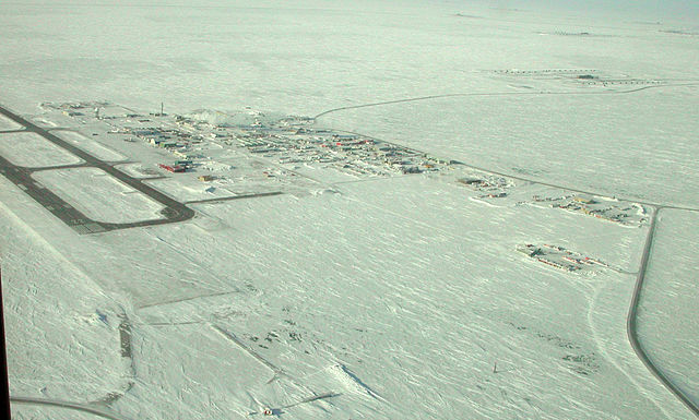
English: PRUDHOE BAY-DEADHORSE, Alaska (March 12, 2007) – At the northern end of the Trans-Alaska Pipeline, Prudhoe Bay-Deadhorse, Alaska, also serves as the beach detachment for the Applied Physics Laboratory Ice Station (APLIS) which has been established on a drifting ice floe about 180 nautical miles north in support of arctic testing for U.S. and U.K submarines. |
||||||
| Date | Prise le 12 mars 2007 | ||||||
| Source |
Navy NewsStand Photo ID: 070312-N-7179R-001 Navy NewsStand Home |
||||||
| Auteur | United States Navy, photographer not specified | ||||||
| Autorisation (Réutilisation de ce fichier) |
|
||||||

Historique du fichier
Cliquer sur une date et heure pour voir le fichier tel qu'il était à ce moment-là.
| Date et heure | Vignette | Dimensions | Utilisateur | Commentaire | |
|---|---|---|---|---|---|
| actuel | 18 février 2008 à 05:54 | | 1 866 × 1 122 (400 kio) | DanMS | {{Information |Description = {{en|PRUDHOE BAY-DEADHORSE, Alaska (March 12, 2007) – At the northern end of the Trans-Alaska Pipeline, Prudhoe Bay-Deadhorse, Alaska, also serves as the beach detachment for the Applied Physics Laboratory Ice Station (AP |
Utilisation du fichier
La page suivante utilise ce fichier :
Usage global du fichier
Les autres wikis suivants utilisent ce fichier :
- Utilisation sur azb.wikipedia.org
- Utilisation sur ce.wikipedia.org
- Utilisation sur cy.wikipedia.org
- Utilisation sur de.wikipedia.org
- Utilisation sur en.wikipedia.org
- Utilisation sur en.wikivoyage.org
- Utilisation sur es.wikipedia.org
- Utilisation sur fa.wikipedia.org
- Utilisation sur fi.wikipedia.org
- Utilisation sur hu.wikipedia.org
- Utilisation sur id.wikipedia.org
- Utilisation sur incubator.wikimedia.org
- Utilisation sur it.wikipedia.org
- Utilisation sur it.wikivoyage.org
- Utilisation sur no.wikipedia.org
- Utilisation sur pl.wikipedia.org
- Utilisation sur ru.wikipedia.org
- Utilisation sur sv.wikipedia.org
- Utilisation sur tt.wikipedia.org
- Utilisation sur uk.wikipedia.org
- Utilisation sur www.wikidata.org
- Utilisation sur zh.wikipedia.org