Fichier:CloudStreets BeringSea 20060120.jpg

Taille de cet aperçu : 600 × 600 pixels. Autres résolutions : 240 × 240 pixels | 480 × 480 pixels | 768 × 768 pixels | 1 024 × 1 024 pixels | 1 620 × 1 620 pixels.
Fichier d’origine (1 620 × 1 620 pixels, taille du fichier : 2,27 Mio, type MIME : image/jpeg)
Ce fichier et sa description proviennent de Wikimedia Commons.
Description
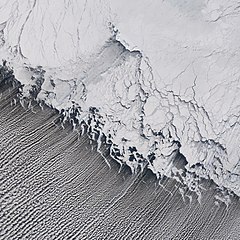
| Description | Satellite image of w:cloud streets in the Bering Sea. w:St. Matthew Island is visible in the upper portion, its mountains casting shadows to the southwest. |
| Date | |
| Source | http://earthobservatory.nasa.gov/Newsroom/NewImages/images.php3?img_id=17171 |
| Auteur | Jesse Allen, NASA Earth Observatory, using data obtained from the Goddard Earth Sciences DAAC. |
| Autorisation (Réutilisation de ce fichier) |
US government, public domain |
Conditions d’utilisation
| Ce fichier provient de la NASA. Sauf exception, les documents créés par la NASA ne sont pas soumis à copyright. Pour plus d'informations, voir la politique de copyright de la NASA. | ||
 |
Attention :
|
Historique du fichier
Cliquer sur une date et heure pour voir le fichier tel qu'il était à ce moment-là.
| Date et heure | Vignette | Dimensions | Utilisateur | Commentaire | |
|---|---|---|---|---|---|
| actuel | 28 avril 2006 à 22:12 | | 1 620 × 1 620 (2,27 Mio) | Holly Cheng | {{Information | Description=Satellite image of w:cloud streets in the Bering Sea. w:St. Matthew Island is visible in the upper portion, its mountains casting shadows to the southwest. | Source=http://earthobservatory.nasa.gov/Newsroom/NewImages/im |
Utilisation du fichier
Les 2 pages suivantes utilisent ce fichier :
Usage global du fichier
Les autres wikis suivants utilisent ce fichier :
- Utilisation sur en.wikipedia.org
- Utilisation sur it.wikipedia.org
- Utilisation sur lmo.wikipedia.org
- Utilisation sur nl.wikipedia.org
- Utilisation sur sv.wikipedia.org