Fichier:Central and Eastern Europe around 950 AD.png
Pas de plus haute résolution disponible.
Central_and_Eastern_Europe_around_950_AD.png (628 × 525 pixels, taille du fichier : 272 kio, type MIME : image/png)
Ce fichier et sa description proviennent de Wikimedia Commons.

Description
| Description |
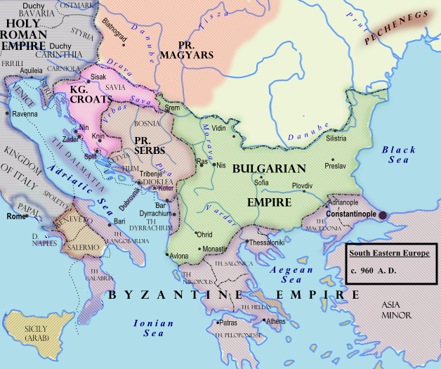
Български: Политическа география на сръбските земи при Чеслав Клонимирович.
English: Southeastern Europe around 950 AD
Español: Europa del Sudeste, hacia 960.
Français : Europe du Sud-Est vers 950 à la mort de Caslav.
Hrvatski: Jugoistočna Europa oko 950. godine.
Română: 950.
Српски / srpski: Оквирни приказ граница на Балкану (око 960. године), крајем Чаславове владавине. |
| Date | 7 février 2009 (date de téléversement originale) |
| Source |
Transféré de en.wikipedia à Commons.
|
| Auteur | Hxseek sur Wikipédia anglais |
![[3]](http://www.lib.utexas.edu/maps/historical/shepherd/europe_byzantine_empires.jpg)
Conditions d’utilisation
| Cette œuvre a été placée dans le domaine public par son auteur, Hxseek sur Wikipédia anglais. Ceci s’applique dans le monde entier. Dans certains pays, ceci peut ne pas être possible ; dans ce cas : Hxseek accorde à toute personne le droit d’utiliser cette œuvre dans n’importe quel but, sans aucune condition, sauf celles requises par la loi. |
Journal des téléversements d’origine
La page de description originale était ici. Tous les noms d'utilisateur qui suivent se rapportent à en.wikipedia.
- 2009-02-07 03:50 Hxseek 628×525× (278873 bytes)
Historique du fichier
Cliquer sur une date et heure pour voir le fichier tel qu'il était à ce moment-là.
| Date et heure | Vignette | Dimensions | Utilisateur | Commentaire | |
|---|---|---|---|---|---|
| actuel | 26 mars 2009 à 12:07 | | 628 × 525 (272 kio) | Captain-tucker | {{Information |Description={{en|== Licensing: ==}} |Source=Transferred from [http://en.wikipedia.org en.wikipedia] |Date=2009-02-07 (original upload date) |Author=Original uploader was Hxseek at [http://en.wikipedia.org en.wikipedia] | |
Utilisation du fichier
La page suivante utilise ce fichier :
Usage global du fichier
Les autres wikis suivants utilisent ce fichier :
- Utilisation sur azb.wikipedia.org
- Utilisation sur be-tarask.wikipedia.org
- Utilisation sur be.wikipedia.org
- Utilisation sur bg.wikipedia.org
- Utilisation sur el.wikipedia.org
- Utilisation sur en.wikipedia.org
- Utilisation sur es.wikipedia.org
- Utilisation sur et.wikipedia.org
- Utilisation sur fi.wikipedia.org
- Utilisation sur gl.wikipedia.org
- Utilisation sur hu.wikipedia.org
- Utilisation sur it.wikipedia.org
- Utilisation sur lt.wikipedia.org
- Utilisation sur lv.wikipedia.org
- Utilisation sur mk.wikipedia.org
- Utilisation sur pl.wikipedia.org
- Utilisation sur pt.wikipedia.org
- Utilisation sur ro.wikipedia.org
- Utilisation sur ru.wikipedia.org
- Utilisation sur sh.wikipedia.org
- Utilisation sur sl.wikipedia.org
- Utilisation sur sr.wikipedia.org
- Utilisation sur th.wikipedia.org
- Utilisation sur uk.wikipedia.org