Fichier:Capital Beltway Map Color.svg

Taille de cet aperçu PNG pour ce fichier SVG : 564 × 489 pixels. Autres résolutions : 277 × 240 pixels | 554 × 480 pixels | 886 × 768 pixels | 1 181 × 1 024 pixels | 2 362 × 2 048 pixels.
Fichier d’origine (Fichier SVG, nominalement de 564 × 489 pixels, taille : 279 kio)
Ce fichier et sa description proviennent de Wikimedia Commons.
Description
| Description |
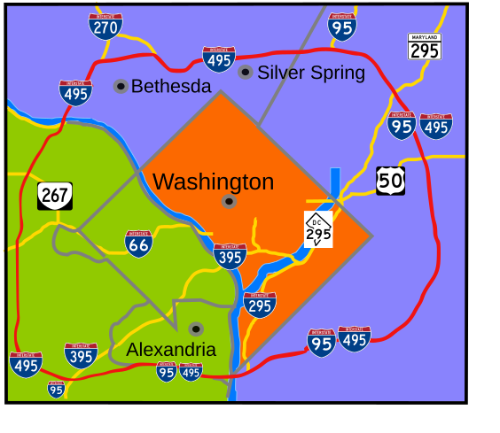
English: Interstate 495 in the state of Maryland and Commonwealth of Virginia in red surrounds the District of Columbia like a "belt", hence the name. |
| Date | |
| Source | Travail personnel |
| Auteur | based on Image:Capital Beltway Map Color.png by Squiggygfm |
Cette image vectorielle non W3C-spécifiée a été créée avec Inkscape .
Conditions d’utilisation
| Moi, propriétaire des droits d’auteur sur cette œuvre, la place dans le domaine public. Ceci s'applique dans le monde entier. Dans certains pays, ceci peut ne pas être possible ; dans ce cas : J’accorde à toute personne le droit d’utiliser cette œuvre dans n’importe quel but, sans aucune condition, sauf celles requises par la loi. |
Historique du fichier
Cliquer sur une date et heure pour voir le fichier tel qu'il était à ce moment-là.
| Date et heure | Vignette | Dimensions | Utilisateur | Commentaire | |
|---|---|---|---|---|---|
| actuel | 23 mars 2008 à 22:49 | | 564 × 489 (279 kio) | RTCNCA | Adjust interstate shields to mark I-95 south of beltway, portion of beltway between 95 and Woodrow Wilson bridge, mark 395 more clearly |
| 30 novembre 2007 à 23:44 |  | 564 × 489 (241 kio) | Rfc1394 | Fix more minor format and placement errors either I should have seen before or didn't notice until after uploaded | |
| 30 novembre 2007 à 23:35 |  | 564 × 489 (243 kio) | Rfc1394 | Slight adjustment to move label "Silver Spring" above the dividing line | |
| 30 novembre 2007 à 23:33 |  | 564 × 489 (241 kio) | Rfc1394 | == Summary == {{Information |Description= Interstate 495 in the state of Maryland and Commonwealth of Virgina in red surrounds the District of Columbia like a "belt", hence the name. |Source=own work |Date= April 26, 2007 |Author= based on [[:Image:Capi |
Utilisation du fichier
La page suivante utilise ce fichier :
Usage global du fichier
Les autres wikis suivants utilisent ce fichier :
- Utilisation sur da.wikipedia.org
- Utilisation sur de.wikipedia.org
- Utilisation sur en.wikipedia.org
- Utilisation sur en.wikibooks.org
- Utilisation sur es.wikipedia.org
- Utilisation sur ja.wikipedia.org
- Utilisation sur sv.wikipedia.org
- Utilisation sur www.wikidata.org
- Utilisation sur zh.wikipedia.org