Fichier:Bissagos archipel-satellite.jpg
Taille de cet aperçu : 600 × 600 pixels. Autres résolutions : 240 × 240 pixels | 480 × 480 pixels | 768 × 768 pixels | 1 024 × 1 024 pixels | 2 048 × 2 048 pixels | 5 264 × 5 264 pixels.
Fichier d’origine (5 264 × 5 264 pixels, taille du fichier : 10,16 Mio, type MIME : image/jpeg)
Ce fichier et sa description proviennent de Wikimedia Commons.
Description
| Description |
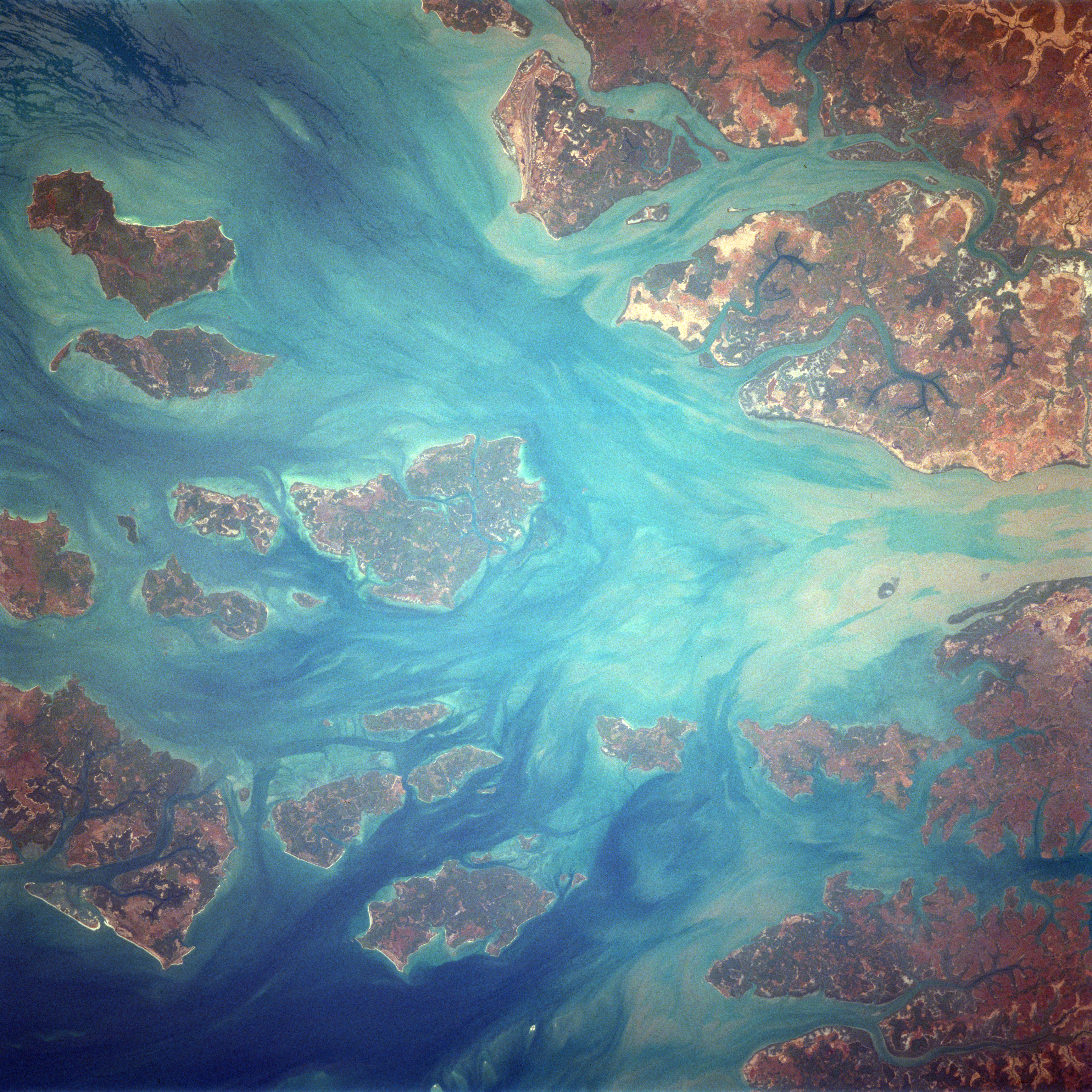
English: Bissagos Archipel
Identification Mission: STS037 Roll: 77 Frame: 71 Mission ID on the Film or image: STS37 Country or Geographic Name: GUINEA-BISSAU Features: ARQUIPELAGO DOS BIJAGOS Center Point Latitude: 11.5 Center Point Longitude: -15.9 (Negative numbers indicate south for latitude and west for longitude) |
| Date | Prise le 6 avril 1991, 14:04:51 UTC |
| Source | https://eol.jsc.nasa.gov/SearchPhotos/photo.pl?mission=STS037&roll=77&frame=71 |
| Auteur | NASA / Crew of STS-37 |
Cette image ou vidéo a été cataloguée par le Johnson Space Center de la National Aeronautics and Space Administration (NASA) des États-Unis sous Photo ID : STS037-77-71.Ce bandeau n’indique rien sur le statut de l’œuvre au regard du droit d'auteur. Un bandeau de droit d’auteur est requis. Voir Commons:À propos des licences pour plus d’informations. Autres langues :
|
Conditions d’utilisation
"The Gateway to Astronaut Photography of Earth". Image provenant du Laboratoire d'Analyse et d'Imagerie des Sciences, Centre Spatial Johnson de la NASA.
Source de la photo : STS037-77-71.
|
Journal des téléversements d’origine
Originally from de.wikipedia; description page is/was here[lien mort]. (All user names refer to de.wikipedia)
- 2004-09-19 09:05 MatthiasKabel 454×458×8 (41870 bytes) Bissagos Archipel, von http://eol.jsc.nasa.gov/scripts/sseop/QuickView.pl?directory=ISD&ID=STS037-77-72, public domain
Historique du fichier
Cliquer sur une date et heure pour voir le fichier tel qu'il était à ce moment-là.
| Date et heure | Vignette | Dimensions | Utilisateur | Commentaire | |
|---|---|---|---|---|---|
| actuel | 17 février 2018 à 19:30 | | 5 264 × 5 264 (10,16 Mio) | Ras67 | high resolution, rotated to approximate north direction |
| 27 février 2007 à 10:36 |  | 454 × 458 (41 kio) | Hardscarf | {{Information |Description=Bissagos Archipel Identification Mission: STS037 Roll: 77 Frame: 71 Mission ID on the Film or image: STS37 Country or Geographic Name: GUINEA-BISSAU Features: ARQUIPELAGO DOS BIJAGOS Center Point Latitude: 11.5 Center Point Lon |
Utilisation du fichier
Aucune page n’utilise ce fichier.
Usage global du fichier
Les autres wikis suivants utilisent ce fichier :
- Utilisation sur ca.wikipedia.org
- Utilisation sur ceb.wikipedia.org
- Utilisation sur de.wikivoyage.org
- Utilisation sur en.wikivoyage.org
- Utilisation sur he.wikivoyage.org
- Utilisation sur it.wikipedia.org
- Utilisation sur nl.wikipedia.org
- Utilisation sur pl.wikipedia.org
- Utilisation sur uk.wikipedia.org
- Utilisation sur www.wikidata.org