Fichier:BattleOfFortWashingtonMapBySauthier.jpg

Taille de cet aperçu : 330 × 600 pixels. Autres résolutions : 132 × 240 pixels | 264 × 480 pixels | 422 × 768 pixels | 563 × 1 024 pixels | 2 528 × 4 595 pixels.
Fichier d’origine (2 528 × 4 595 pixels, taille du fichier : 4,79 Mio, type MIME : image/jpeg)
Ce fichier et sa description proviennent de Wikimedia Commons.
Description
| Description |
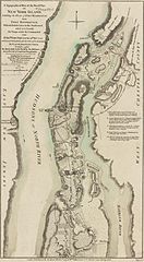
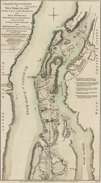
English: This map depicts the northern end of Manhattan, and the military fortifications in the area in 1776, during the American Revolutionary War. It has markings describing the military movements of the Battle of Fort Washington, fought November 16, 1776.
The map's caption reads: A Topographical Map of the Northn. Part of New York Island, Exhibiting the Plan of Fort Washington, now Fort Knyphausen, With the Rebels Lines to the Southward, which were forced by the Troops under the Command of the Rt. Honble. Earl Percy, on the 16th Novr. 1776, and Survey'd immediately after by Order of his Lordship, By Claude Joseph Sauthier. To which is added the Attack made to the Northd. by the Hessians Survey'd by Order of Lieutt. Genl. Knyphausen. Published by Permission of The Rt. Honble. the Commissioners of Trade & Plantations. By Wm. Faden, 1777. |
|||||||||||||||||||||||||||||||||||||||||
| Date | ||||||||||||||||||||||||||||||||||||||||||
| Source |
From the Boston Public Library Digital Map Collection: http://maps.bpl.org/details_10863/ |
|||||||||||||||||||||||||||||||||||||||||
| Auteur |
|
|||||||||||||||||||||||||||||||||||||||||
| Autres versions |
 |
|||||||||||||||||||||||||||||||||||||||||
Conditions d’utilisation
Ce document est dans le domaine public aux États-Unis. Ceci s'applique aux travaux des États-Unis où le copyright a expiré, souvent parce que sa première publication s'est produite avant le 1er janvier 1929. Voir cette page pour davantage d'explication.
|
 | |
 |
Cette image peut ne pas être dans le domaine public en dehors des États-Unis (ceci s'applique particulièrement au Canada, en Chine (pas Hong Kong, Macao, ni Taïwan), en Allemagne ou en Suisse). Le créateur et l'année de la publication sont l'information essentielle et doivent être fournis.
|
|
Ceci est une reproduction photographique fidèle d'une œuvre d'art originale en deux dimensions. L'œuvre d'art elle-même est dans le domaine public pour la raison suivante :
La position officielle de la Fondation Wikimedia est que « les représentations fidèles des œuvres d'art du domaine public en deux dimensions sont dans le domaine public et les exigences contraires sont une attaque contre le concept même de domaine public ». Pour plus de détails, voir Commons:Quand utiliser le bandeau PD-Art.
Cette reproduction photographique est donc également considérée comme étant élevée dans le domaine public. Merci de noter qu'en fonction des lois locales, la réutilisation de ce contenu peut être interdite ou restreinte dans votre juridiction. Voyez Commons:Reuse of PD-Art photographs. | ||||
Historique du fichier
Cliquer sur une date et heure pour voir le fichier tel qu'il était à ce moment-là.
| Date et heure | Vignette | Dimensions | Utilisateur | Commentaire | |
|---|---|---|---|---|---|
| actuel | 22 avril 2009 à 21:27 | | 2 528 × 4 595 (4,79 Mio) | Magicpiano | {{Information |Description={{en|1=This map depicts the northern end of w:Manhattan, and the military fortifications in the area in 1776, during the w:American Revolutionary War. It has markings describing the military movements of the [[w:Battl |
Utilisation du fichier
La page suivante utilise ce fichier :
Usage global du fichier
Les autres wikis suivants utilisent ce fichier :
- Utilisation sur en.wikipedia.org
- Utilisation sur es.wikipedia.org
- Utilisation sur it.wikipedia.org
- Utilisation sur ja.wikipedia.org
- Utilisation sur nl.wikipedia.org
- Utilisation sur pt.wikipedia.org
- Utilisation sur www.wikidata.org