Fichier:Aitken clem big.gif
Taille de cet aperçu : 600 × 600 pixels. Autres résolutions : 240 × 240 pixels | 622 × 622 pixels.
Fichier d’origine (622 × 622 pixels, taille du fichier : 162 kio, type MIME : image/gif)
Ce fichier et sa description proviennent de Wikimedia Commons.
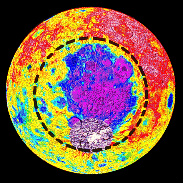
| Description | This image is an elevation map of the South Pole-Aitken basin on the Moon, derived from data collected by the NASA/SDIO probe Clementine. [1] establishes that the colors represent elevations, but unfortunately the resolution is too low for me to make out what numbers go with what hues. |
| Source | http://antwrp.gsfc.nasa.gov/apod/ap960906.html |
| Auteur | Clementine Project |
| Autres versions |
 |
![[1]](http://solarsystem.nasa.gov/multimedia/gallery/Aiken_Maps.jpg)
| Ce fichier provient de la NASA. Sauf exception, les documents créés par la NASA ne sont pas soumis à copyright. Pour plus d'informations, voir la politique de copyright de la NASA. | ||
 |
Attention :
|
Historique du fichier
Cliquer sur une date et heure pour voir le fichier tel qu'il était à ce moment-là.
| Date et heure | Vignette | Dimensions | Utilisateur | Commentaire | |
|---|---|---|---|---|---|
| actuel | 21 mai 2006 à 20:55 | | 622 × 622 (162 kio) | Bryan Derksen | Cropping and removing dither fuzz from the black background areas to reduce file size. |
| 21 mai 2006 à 20:40 |  | 800 × 622 (283 kio) | Bryan Derksen | {{Information| |Description=This image is an elevation map of the en:South Pole-Aitken basin on the Moon, derived from data collected by the NASA/SDIO probe en:Clementine (probe). [http://solarsystem.nasa.gov/multimedia/gallery/Aiken_Maps.jpg] est |
Utilisation du fichier
La page suivante utilise ce fichier :
Usage global du fichier
Les autres wikis suivants utilisent ce fichier :
- Utilisation sur be.wikipedia.org
- Utilisation sur bg.wikipedia.org
- Utilisation sur ca.wikipedia.org
- Utilisation sur da.wikipedia.org
- Utilisation sur en.wikiversity.org
- Utilisation sur eo.wikipedia.org
- Utilisation sur es.wikipedia.org
- Utilisation sur fi.wikipedia.org
- Utilisation sur it.wikipedia.org
- Utilisation sur lb.wikipedia.org
- Utilisation sur nl.wikipedia.org
- Utilisation sur pl.wikipedia.org