Fichier:Aerial view of the Central Intelligence Agency headquarters, Langley, Virginia - Corrected and Cropped.jpg
Taille de cet aperçu : 800 × 356 pixels. Autres résolutions : 320 × 142 pixels | 640 × 284 pixels | 1 024 × 455 pixels | 1 280 × 569 pixels | 2 560 × 1 138 pixels | 5 523 × 2 455 pixels.
Fichier d’origine (5 523 × 2 455 pixels, taille du fichier : 7,57 Mio, type MIME : image/jpeg)
Ce fichier et sa description proviennent de Wikimedia Commons.
Description
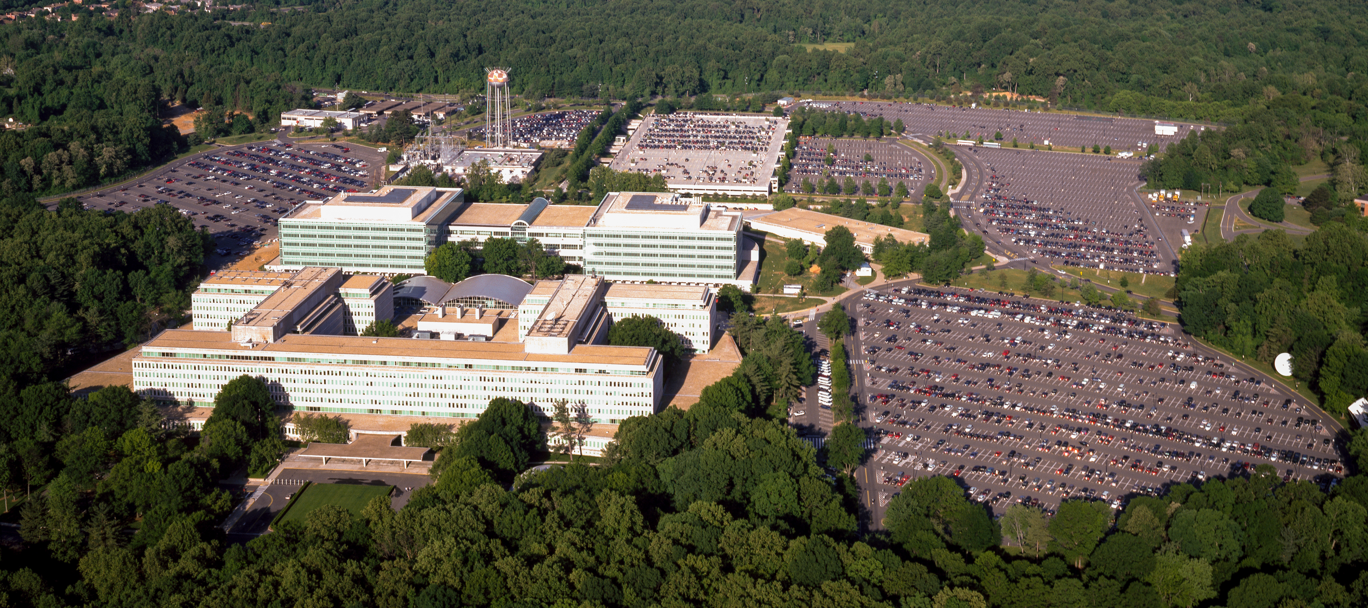
| Aerial view of the Central Intelligence Agency headquarters, Langley, Virginia
( |
|||||||||||||||||||||||||||
|---|---|---|---|---|---|---|---|---|---|---|---|---|---|---|---|---|---|---|---|---|---|---|---|---|---|---|---|
| Auteur |
|
||||||||||||||||||||||||||
| Titre |
Aerial view of the Central Intelligence Agency headquarters, Langley, Virginia |
||||||||||||||||||||||||||
| Lieu représenté | Central Intelligence Agency headquarters | ||||||||||||||||||||||||||
| Date | entre 1980 et 2006 | ||||||||||||||||||||||||||
| Technique / matériaux | 1 transparency : color | ||||||||||||||||||||||||||
| Dimensions | 4 x 5 in. or smaller. | ||||||||||||||||||||||||||
| Collection |
|
||||||||||||||||||||||||||
| Lieu actuel |
Prints and Photographs Division http://hdl.loc.gov/loc.pnp/pp.print |
||||||||||||||||||||||||||
| Notes |
|
||||||||||||||||||||||||||
| Source |
|
||||||||||||||||||||||||||
| Autorisation (Réutilisation de ce fichier) |
Rights Advisory: No known restrictions on publication. | ||||||||||||||||||||||||||
| Autres versions |
|
||||||||||||||||||||||||||


| | Voir cet endroit et d’autres images sur : OpenStreetMap |
Conditions d’utilisation
| Cette œuvre est issue de la Carol M. Highsmith Archive collection de la Bibliothèque du Congrès. Selon la bibliothèque, il n'existe aucune restriction connue en matière de droits d'auteur pour l'utilisation de cette œuvre. Carol M. Highsmith has stipulated that her photographs are in the public domain. Photographs of sculpture or other works of art may be restricted by the copyright of the artist. |
 |
Historique du fichier
Cliquer sur une date et heure pour voir le fichier tel qu'il était à ce moment-là.
| Date et heure | Vignette | Dimensions | Utilisateur | Commentaire | |
|---|---|---|---|---|---|
| actuel | 22 avril 2017 à 18:17 | | 5 523 × 2 455 (7,57 Mio) | Falcorian | User created page with UploadWizard |
Utilisation du fichier
Les 3 pages suivantes utilisent ce fichier :
Usage global du fichier
Les autres wikis suivants utilisent ce fichier :
- Utilisation sur ar.wikipedia.org
- Utilisation sur arz.wikipedia.org
- Utilisation sur ast.wikipedia.org
- Utilisation sur azb.wikipedia.org
- Utilisation sur az.wikipedia.org
- Utilisation sur br.wikipedia.org
- Utilisation sur ca.wikipedia.org
- Utilisation sur ce.wikipedia.org
- Utilisation sur cs.wikipedia.org
- Utilisation sur cy.wikipedia.org
- Utilisation sur da.wikipedia.org
- Utilisation sur de.wikipedia.org
- Utilisation sur en.wikipedia.org
- Utilisation sur eo.wikipedia.org
- Utilisation sur eo.wikiquote.org
- Utilisation sur es.wikipedia.org
- Utilisation sur fi.wikipedia.org
- Utilisation sur fr.wikinews.org
- Utilisation sur ga.wikipedia.org
- Utilisation sur ha.wikipedia.org
- Utilisation sur he.wikipedia.org
- Utilisation sur hu.wikipedia.org
- Utilisation sur id.wikipedia.org
- Utilisation sur it.wikipedia.org
- Utilisation sur ja.wikipedia.org
- Utilisation sur ko.wikipedia.org
- Utilisation sur ky.wikipedia.org
- Utilisation sur lv.wikipedia.org
- Utilisation sur mn.wikipedia.org
- Utilisation sur ne.wikipedia.org
- Utilisation sur nn.wikipedia.org
- Utilisation sur no.wikipedia.org
- Utilisation sur ro.wikipedia.org
- Utilisation sur ru.wikipedia.org
- Utilisation sur ru.wikinews.org
- Utilisation sur sk.wikipedia.org
- Utilisation sur sl.wikipedia.org
- Utilisation sur sr.wikipedia.org
- Utilisation sur te.wikipedia.org
Voir davantage sur l’utilisation globale de ce fichier.