Fichier:1976 Helsinki tram map.png

Taille de cet aperçu : 600 × 600 pixels. Autres résolutions : 240 × 240 pixels | 480 × 480 pixels | 768 × 768 pixels | 1 200 × 1 200 pixels.
Fichier d’origine (1 200 × 1 200 pixels, taille du fichier : 111 kio, type MIME : image/png)
Ce fichier et sa description proviennent de Wikimedia Commons.
Description
| Description |
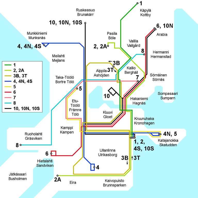
English: Map of the Helsinki tram network as it appeared in 1976 and 1977.
Suomi: Kartta Helsingin raitiotielinjastosta sellaisena kuin se oli vuosina 1976 ja 1977.
Svenska: Karten över Helsingfors spårvägsnätet under år 1976 och 1977. |
| Date | |
| Source | Travail personnel |
| Auteur | Kalle Id |

|
Cette image (de type transport map) devrait être recréée dans un format vectoriel, en tant que fichier SVG. Cela offrirait plusieurs avantages : voir Commons:Media for cleanup pour plus d'informations. Si une version SVG de cette image est déjà disponible, merci de bien vouloir l'envoyer. Après cela, remplacez ce modèle par {{vector version available|nouveau nom d'image.svg}}.
|
Conditions d’utilisation
Moi, en tant que détenteur des droits d’auteur sur cette œuvre, je la publie sous la licence suivante :
Ce fichier est disponible selon les termes de la licence Creative Commons Attribution – Partage dans les Mêmes Conditions 3.0 (non transposée).
- Vous êtes libre :
- de partager – de copier, distribuer et transmettre cette œuvre
- d’adapter – de modifier cette œuvre
- Sous les conditions suivantes :
- paternité – Vous devez donner les informations appropriées concernant l'auteur, fournir un lien vers la licence et indiquer si des modifications ont été faites. Vous pouvez faire cela par tout moyen raisonnable, mais en aucune façon suggérant que l’auteur vous soutient ou approuve l’utilisation que vous en faites.
- partage à l’identique – Si vous modifiez, transformez, ou vous basez sur cette œuvre, vous devez distribuer votre contribution sous la même licence ou une licence compatible avec celle de l’original.
Historique du fichier
Cliquer sur une date et heure pour voir le fichier tel qu'il était à ce moment-là.
| Date et heure | Vignette | Dimensions | Utilisateur | Commentaire | |
|---|---|---|---|---|---|
| actuel | 30 juin 2010 à 14:22 | | 1 200 × 1 200 (111 kio) | Kjet | Improved geographical accuracy, altered line colours to match with other historical maps, bilingual names |
| 4 octobre 2008 à 19:48 |  | 1 200 × 1 200 (76 kio) | Kjet | Improved grographical accuracy | |
| 17 août 2008 à 17:50 |  | 1 200 × 1 200 (75 kio) | Kjet | Improved accuracy. | |
| 7 août 2008 à 20:05 |  | 1 200 × 1 200 (76 kio) | Kjet | Corrected anachronism in the route of line number 3. | |
| 25 juillet 2008 à 13:27 |  | 1 200 × 1 200 (75 kio) | Kjet | {{Information |Description={{en|1=Map of the Helsinki tram network as it appeared between 1976 and 1980. District names in Finnish, a Swedish version can be made on request.}} {{fi|1=Kartta Helsingin raitiotielinjastosta sellaisena kuin se oli vuosien 197 |
Utilisation du fichier
La page suivante utilise ce fichier :
Usage global du fichier
Les autres wikis suivants utilisent ce fichier :
- Utilisation sur en.wikipedia.org
- Utilisation sur fi.wikipedia.org
- Utilisation sur sv.wikipedia.org
- Utilisation sur uk.wikipedia.org