Fichier:1906 Boatwright intensity.jpg

Taille de cet aperçu : 415 × 599 pixels. Autres résolutions : 166 × 240 pixels | 612 × 884 pixels.
Fichier d’origine (612 × 884 pixels, taille du fichier : 539 kio, type MIME : image/jpeg)
Ce fichier et sa description proviennent de Wikimedia Commons.
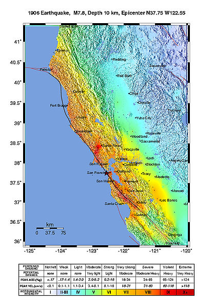
Description
Public Domain
Intensity map for the 1906 San Francisco Earthquake deduced from the Lawson report
from U.S. Geological Survey Open-File Report 2005-1135
Modified Mercalli Intensity Maps for the 1906 San Francisco Earthquake Plotted in ShakeMap Format
By John Boatwright and Howard Bundock
Conditions d’utilisation
Cette image est placée dans le domaine public parce qu'elle contient des éléments issus de l'United States Geological Survey, une agence du Département de l'Intérieur des États-Unis. Pour plus d'information, consultez la politique officielle de copyright de l'USGS (en anglais)
|
Historique du fichier
Cliquer sur une date et heure pour voir le fichier tel qu'il était à ce moment-là.
| Date et heure | Vignette | Dimensions | Utilisateur | Commentaire | |
|---|---|---|---|---|---|
| actuel | 30 mai 2006 à 23:45 | | 612 × 884 (539 kio) | Andre315 | Public Domain<br/> Intensity map for the 1906 San Francisco Earthquake deduced from the Lawson report<br/> from U.S. Geological Survey Open-File Report 2005-1135<br/> Modified Mercalli Intensity Maps for the 1906 San Francisco Earthquake Plotted in ShakeM |
Utilisation du fichier
Les 2 pages suivantes utilisent ce fichier :
Usage global du fichier
Les autres wikis suivants utilisent ce fichier :
- Utilisation sur cs.wikipedia.org
- Utilisation sur de.wikipedia.org
- Utilisation sur en.wikipedia.org
- Utilisation sur gl.wikipedia.org
- Utilisation sur hu.wikipedia.org
- Utilisation sur ka.wikipedia.org
- Utilisation sur ko.wikipedia.org
- Utilisation sur ms.wikipedia.org
- Utilisation sur nl.wikipedia.org
- Utilisation sur tr.wikipedia.org