Fichier:1747 La Feuille Map of Scotland - Geographicus - Ecosse-ratelband-1747.jpg

Taille de cet aperçu : 800 × 566 pixels. Autres résolutions : 320 × 226 pixels | 640 × 453 pixels | 1 024 × 725 pixels | 1 280 × 906 pixels | 2 500 × 1 769 pixels.
Fichier d’origine (2 500 × 1 769 pixels, taille du fichier : 1,77 Mio, type MIME : image/jpeg)
Ce fichier et sa description proviennent de Wikimedia Commons.
| Daniel de Lafeuille : Carte Nouvelle D'Ecosse. - Nieuwe Kaart van Schotland.
( |
||||||||||||||||||||
|---|---|---|---|---|---|---|---|---|---|---|---|---|---|---|---|---|---|---|---|---|
| Artiste |
|
|||||||||||||||||||
| Titre |
Carte Nouvelle D'Ecosse. - Nieuwe Kaart van Schotland. |
|||||||||||||||||||
| Description |
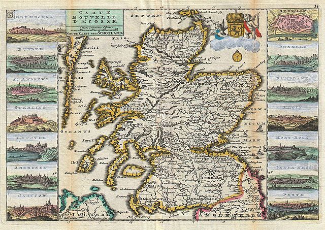
English: A stunning map of Scotland first drawn by Daniel de la Feuille in 1706. Depicts the entirety of Scotland surrounded by views of fourteen Scottish cities, including Edembourg (Edinburgh), Dundee, St. Andrews, Sterling, Dunoter, Aberdeen, Glascow (Glasgow), Berwick, Dunkeld, Dunblane, Elgin, Mont-Rose, Inner-ness and Perth. A playful cartouche in the upper right quadrant depicts the armorial crest of Scotland surmounted by a crown and flanked by cherubs. Four tiny sailing ships and two rowboats are drawn plying the waters near Edinburgh. Title in upper left quadrant in both French and Dutch. This is Paul de la Feuille’s 1747 reissue of his father Daniel’s 1706 map. Prepared for issue as plate no. 17 in J. Ratelband’s 1747 Geographisch-Toneel . |
|||||||||||||||||||
| Date | 1747 (undated) | |||||||||||||||||||
| Dimensions | hauteur : 7 pouces (17,7 cm) ; largeur : 10,2 pouces (26 cm) | |||||||||||||||||||
| Numéro d’inventaire |
liens Geographicus : Ecosse-ratelband-1747 |
|||||||||||||||||||
| Source / photographe |
Geographisch-Toneel Of uitgezochte Kaarten, Tot gemak der Officieren, Reisigers en Liefhebbers; Behelsende alle de generale Kaarten ..., (1747 J. Ratelband issue.)
|
|||||||||||||||||||
| Autorisation (Réutilisation de ce fichier) |
|
|||||||||||||||||||
Historique du fichier
Cliquer sur une date et heure pour voir le fichier tel qu'il était à ce moment-là.
| Date et heure | Vignette | Dimensions | Utilisateur | Commentaire | |
|---|---|---|---|---|---|
| actuel | 18 mars 2011 à 11:18 | | 2 500 × 1 769 (1,77 Mio) | BotMultichill | {{subst:User:Multichill/Geographicus |link=http://www.geographicus.com/P/AntiqueMap/Ecosse-ratelband-1747 |product_name=1747 La Feuille Map of Scotland |map_title=Carte Nouvelle D'Ecosse. - Nieuwe Kaart van Schotland. |description=A stunning map of Scotla |
Utilisation du fichier
La page suivante utilise ce fichier :
Usage global du fichier
Les autres wikis suivants utilisent ce fichier :
- Utilisation sur de.wikipedia.org