Fichier:1744 Wren Map of London, England - Geographicus - London-wren-1744.jpg
Fichier d’origine(5 000 × 3 496 pixels, taille du fichier : 4,43 Mio, type MIME : image/jpeg)

Ce fichier et sa description proviennent de Wikimedia Commons.

Christopher Wren : Ichnographia urbis Londinii… (A Plan of the City of London, after the great FIRE, in the Year of Our Lord 1666.)   (Wikidata search (Cirrus search) Wikidata query (SPARQL)  Create new Wikidata item based on this file)
Artiste
Christopher Wren  (1632–1723)  wikidata:Q170373 s:en:Author:Christopher Michael Wren q:en:Christopher Wren
 
Christopher Wren
Autres noms
Sir Christopher Wren
Description architecte, astronome, mathématicien ou mathématicienne, physicien ou physicienne, anatomiste et professeur ou professeure d'université britannique
Date de naissance / décès 20 octobre 1632 (dans le calendrier julienÉditer sur Wikidata 25 février 1723 (dans le calendrier julienÉditer sur Wikidata
Lieu de naissance / décès East Knoyle Londres
Période d’activité 1657-1710
Lieu de travail
Autorité
artist QS:P170,Q170373
Titre
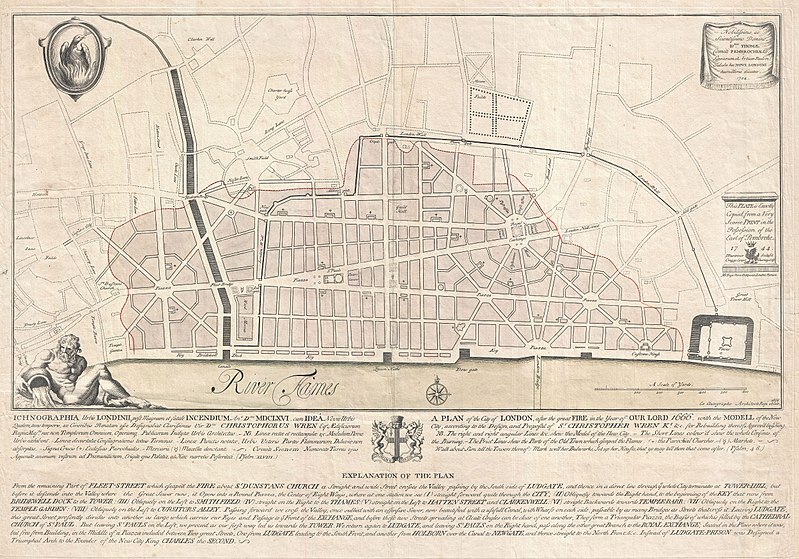
Ichnographia urbis Londinii… (A Plan of the City of London, after the great FIRE, in the Year of Our Lord 1666.)
Description
English: An extremely scarce 1744 map of London showing Sir Christopher Wren's plan for reconstructing the city following the 1666 Great Fire of London. In 1666 the Great Fire swept through the old Roman portions of London, laying waste to most of the original walled city. Christopher Wren, a well known architect of the period was quick to respond to the disaster as a opportunity to dramatically redesign and modernize London's center. Wren having been schooled in Paris envisioned an elaborate classically influenced reconstruction of the city with broad avenues meeting in a series of Piazzas. Despite, or perhaps because of, Wren's promptitude in producing a plan for a major post-fire reconstruction, his plan exhibits a number of dramatic errors. Wren did not take the city's topography into account and consequently much of the this plan is unfeasible. Despite claims to the contrary in the document itself, Wren's plan was never seriously considered by either the King or the Parliament. Today Wren's original 1666 plan is lost. This version was drawn in 1744 by the once fashionable engrave P. Fourdrinier, who claims to have replicated exactly a scarce 1724 original owned by the Earl of Pembroke. This map covers London along the north side of the Thames River from Strand Bridge to Great Tower Hill. Shows Wren's detailed reconstruction plan, along with the regions originally destroyed by the Great Fire. Identifies the proposed locations of parochial churches, markets, piazzas, bridges and warehouses. A vignette in the lower left quadrant depicts Thamesis, the river god for which the Thames River is named. The upper left quadrant bears the image of a phoenix, suggesting that, like the mythical bird, London too would rise from its own ashes and be reborn in fire. The lower quadrants of this plate include the map's title in both English and Latin as well as a detailed Explanation of the Plan. This plan is highly uncommon and rarely appears outside of institutional collections.
Date 1744 (dated)
Dimensions hauteur : 19 pouces (48,2 cm) ; largeur : 27,5 pouces (69,8 cm)
dimensions QS:P2048,19U218593
dimensions QS:P2049,27.5U218593
Numéro d’inventaire
liens Geographicus : London-wren-1744
Source / photographe
Autorisation
(Réutilisation de ce fichier)
Ceci est une reproduction photographique fidèle d'une œuvre d'art originale en deux dimensions. L'œuvre d'art elle-même est dans le domaine public pour la raison suivante :
Public domain

Cette œuvre est également dans le domaine public dans tous les pays pour lesquels le droit d’auteur a une durée de vie de 100 ans ou moins après la mort de l’auteur.


Vous devez aussi inclure un modèle indiquant pourquoi cette œuvre est dans le domaine public aux États-Unis.
La position officielle de la Fondation Wikimedia est que « les représentations fidèles des œuvres d'art du domaine public en deux dimensions sont dans le domaine public et les exigences contraires sont une attaque contre le concept même de domaine public ». Pour plus de détails, voir Commons:Quand utiliser le bandeau PD-Art.
Cette reproduction photographique est donc également considérée comme étant élevée dans le domaine public. Merci de noter qu'en fonction des lois locales, la réutilisation de ce contenu peut être interdite ou restreinte dans votre juridiction. Voyez Commons:Reuse of PD-Art photographs.
Public domain
Cette œuvre est dans le domaine public aux États-Unis car elle a été publiée avant le 1er janvier 1929.

Les œuvres dans le domaine public doivent être inéligibles pour le droit d'auteur à la fois aux États-Unis et dans leur pays d'origine pour pouvoir être hébergées sur Commons. Si l'œuvre ne provient pas des États-Unis, le fichier doit comporter un bandeau de licence supplémentaire indiquant la situation vis-à-vis du droit d'auteur dans le pays d'origine.

Légendes

Ajoutez en une ligne la description de ce que représente ce fichier

Éléments décrits dans ce fichier

dépeint

image/jpeg

aac4573c33ddccb69d1cadc3765e753878fd91b4

4 649 137 octet

3 496 pixel

5 000 pixel

Historique du fichier

Cliquer sur une date et heure pour voir le fichier tel qu'il était à ce moment-là.

Date et heureVignetteDimensionsUtilisateurCommentaire
actuel23 mars 2011 à 22:42Vignette pour la version du 23 mars 2011 à 22:425 000 × 3 496 (4,43 Mio)BotMultichillT{{subst:User:Multichill/Geographicus |link=http://www.geographicus.com/P/AntiqueMap/London-wren-1744 |product_name=1744 Wren Map of London, England |map_title=Ichnographia urbis Londinii… (A Plan of the City of London, after the great FIRE, in the Year

Les 3 pages suivantes utilisent ce fichier :

Usage global du fichier

Les autres wikis suivants utilisent ce fichier :