Fichier:Wilkins Ice Bridge Collapse (2).jpg

Taille de cet aperçu : 480 × 600 pixels. Autres résolutions : 192 × 240 pixels | 384 × 480 pixels.
Fichier d’origine (800 × 1 000 pixels, taille du fichier : 177 kio, type MIME : image/jpeg)
Ce fichier et sa description proviennent de Wikimedia Commons.
.jpg?uselang=fr)
Description
| Description |
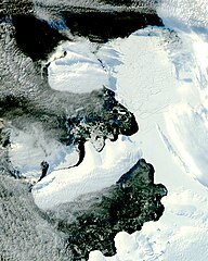
English: The MODIS instrument on NASA’s Aqua satellite captured this image. It shows that the smooth ice bridge connecting Charcot Island and Latady Island up to 31 March 2009 is gone, replaced by chunks of ice. |
| Date | |
| Source | http://earthobservatory.nasa.gov/IOTD/view.php?id=37806&src=iotdrss |
| Auteur | Jeff Schmaltz |
NASA image courtesy Jeff Schmaltz, MODIS Rapid Response Team at NASA GSFC.
Conditions d’utilisation
| Ce fichier provient de la NASA. Sauf exception, les documents créés par la NASA ne sont pas soumis à copyright. Pour plus d'informations, voir la politique de copyright de la NASA. | ||
 |
Attention :
|
Historique du fichier
Cliquer sur une date et heure pour voir le fichier tel qu'il était à ce moment-là.
| Date et heure | Vignette | Dimensions | Utilisateur | Commentaire | |
|---|---|---|---|---|---|
| actuel | 19 avril 2009 à 16:07 | | 800 × 1 000 (177 kio) | Originalwana | {{Information |Description={{en|1=The MODIS instrument on NASA’s Aqua satellite captured this image. It shows that the smooth ice bridge connecting Charcot Island and Latady Island up to 31 March 2009 is gone, replaced by chunks of ice.}} |Source=http:/ |
Utilisation du fichier
La page suivante utilise ce fichier :
Usage global du fichier
Les autres wikis suivants utilisent ce fichier :
- Utilisation sur en.wikipedia.org
- Utilisation sur it.wikipedia.org
- Utilisation sur nn.wikipedia.org
- Utilisation sur pl.wikipedia.org
.jpg)