Fichier:Wilderness road en.png

Taille de cet aperçu : 800 × 508 pixels. Autres résolutions : 320 × 203 pixels | 640 × 406 pixels | 1 024 × 650 pixels | 1 254 × 796 pixels.
Fichier d’origine (1 254 × 796 pixels, taille du fichier : 1,74 Mio, type MIME : image/png)
Ce fichier et sa description proviennent de Wikimedia Commons.
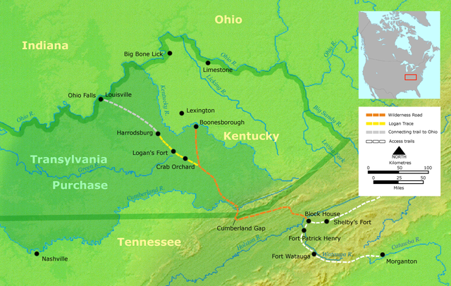
- Description: Course of the Wilderness Road in Kentucky by 2013. Darker green outlines represent the later boundaries of Kentucky, while green shading represents the Transylvania Purchase.
- Source: Own work by Nikater, submitted to the public domain. Background map courtesy of Demis, www.demis.nl.
- Uploader: User:Nikater
- date;14 April 2000
- Other Versions: German Image:Wilderness road_de.png
- License status:
This image is in the public domain because it came from the site https://www.demis.nl/products/web-map-server/examples/ and was released by the copyright holder. Permission is granted to copy, distribute and/or modify this map since it is based on free of copyright images from: www.demis.nl. See also approval email on de.wp and its clarification.
|
| This work has been released into the public domain by its copyright holder, www.demis.nl. This applies worldwide. Dans certains pays, ceci peut ne pas être possible ; dans ce cas : www.demis.nl accorde à toute personne le droit d’utiliser cette œuvre dans n’importe quel but, sans aucune condition, sauf celles requises par la loi.
|

|
Cette image (de type carte) devrait être recréée dans un format vectoriel, en tant que fichier SVG. Cela offrirait plusieurs avantages : voir Commons:Media for cleanup pour plus d'informations. Si une version SVG de cette image est déjà disponible, merci de bien vouloir l'envoyer. Après cela, remplacez ce modèle par {{vector version available|nouveau nom d'image.svg}}.
|
Historique du fichier
Cliquer sur une date et heure pour voir le fichier tel qu'il était à ce moment-là.
| Date et heure | Vignette | Dimensions | Utilisateur | Commentaire | |
|---|---|---|---|---|---|
| actuel | 23 mars 2007 à 21:16 | | 1 254 × 796 (1,74 Mio) | Nikater | * Description: Course of the Wilderness Road in Kentucky by 1785 * Source: Own work by Nikater, submitted to the public domain. Background map courtesy of Demis, www.demis.nl. * Uploader: User:Nikater * Date: 23 Mar 2007 * Other Versions: German: Imag |
| 21 mars 2007 à 15:24 |  | 1 254 × 796 (1,74 Mio) | Nikater | * Description: Course of the Wilderness Road in Kentucky by 1785 * Source: Own work by Nikater, submitted to the public domain. Background map courtesy of Demis, www.demis.nl. * Uploader: User:Nikater * Date: 21 Mar 2007 * Other Versions: German: Imag | |
| 18 mars 2007 à 19:17 |  | 1 254 × 796 (1,74 Mio) | Nikater | * Description: Course of the Wilderness Road in Kentucky by 1785 * Source: Own work by Nikater, submitted to the public domain. Background map courtesy of Demis, www.demis.nl. * Uploader: User:Nikater * Date: 18 Mar 2007 * Other Versions: German: Imag | |
| 17 mars 2007 à 14:13 |  | 1 255 × 760 (1,63 Mio) | Nikater | * Description: Course of the Wilderness Road in Kentucky by 1785 * Source: Own work by Nikater, submitted to the public domain. Background map courtesy of Demis, www.demis.nl. * Uploader: User:Nikater * Date: 17 Mar 2007 * Other Versions: German [[Ima |
Utilisation du fichier
Les 2 pages suivantes utilisent ce fichier :
Usage global du fichier
Les autres wikis suivants utilisent ce fichier :
- Utilisation sur ar.wikipedia.org
- Utilisation sur ca.wikipedia.org
- Utilisation sur da.wikipedia.org
- Utilisation sur de.wikipedia.org
- Utilisation sur en.wikipedia.org
- Henderson, Kentucky
- Elizabethton, Tennessee
- Clarksville, Tennessee
- American frontier
- Transylvania Colony
- Boonesborough, Kentucky
- Wilderness Road
- Cumberland Gap
- Big Bone, Kentucky
- Richard Henderson (jurist)
- Logan Trace
- Sycamore Shoals
- Cherokee–American wars
- User talk:Kevin1776/Archive 2
- John W. Frazer
- User:Brendan.Hunstad/draft on Cumberland Gap
- User:Drdpw/sandbox2
- Utilisation sur es.wikipedia.org
- Utilisation sur it.wikipedia.org
- Utilisation sur ja.wikipedia.org
- Utilisation sur nl.wikipedia.org
- Utilisation sur no.wikipedia.org
- Utilisation sur pl.wikipedia.org
- Utilisation sur ru.wikipedia.org