Fichier:Western Addition neighborhood, San Francisco, California LCCN2013630355.tif

Taille de cet aperçu JPG pour ce fichier TIF : 400 × 599 pixels. Autres résolutions : 160 × 240 pixels | 320 × 480 pixels | 512 × 768 pixels | 683 × 1 024 pixels | 1 367 × 2 048 pixels | 4 912 × 7 360 pixels.
Fichier d’origine (4 912 × 7 360 pixels, taille du fichier : 206,9 Mio, type MIME : image/tiff)
Ce fichier et sa description proviennent de Wikimedia Commons.
Description
| Description |
English: Title: Western Addition neighborhood, San Francisco, California
Physical description: 1 photograph : digital, tiff file, color. Notes: Title, date, and keywords provided by the photographer.; Built and settled in the 19th and early 20th century, Japanese immigrants began moving into the area following the 1906 Earthquake. By World War II, the neighborhood was one of the largest such enclaves of Japanese outside of Japan and it took on the appearahce of the Ginza district in Tokyo.; Credit line: The Jon B. Lovelace Collection of California Photographs in Carol M. Highsmith's America Project, Library of Congress, Prints and Photographs Division.; Forms part of: Jon B. Lovelace Collection of California Photographs in Carol M. Highsmith's America Project in the Carol M. Highsmith Archive.; Gift; The Capital Group Companies Charitable Foundation in memory of Jon B. Lovelace; 2012; (DLC/PP-2012:063). |
||||||||||||||||||||||||||
| Date | Prise le 31 mai 2012, 00:52 (d'après les données Exif) | ||||||||||||||||||||||||||
| Source |
Library of Congress
|
||||||||||||||||||||||||||
| Auteur |
|
||||||||||||||||||||||||||
| Autorisation (Réutilisation de ce fichier) |
No known restrictions on publication.
|
||||||||||||||||||||||||||


| Lieu de la prise de vue | | Voir cet endroit et d’autres images sur : OpenStreetMap |
|---|
Conditions d’utilisation
| Cette œuvre est issue de la Carol M. Highsmith Archive collection de la Bibliothèque du Congrès. Selon la bibliothèque, il n'existe aucune restriction connue en matière de droits d'auteur pour l'utilisation de cette œuvre. Carol M. Highsmith has stipulated that her photographs are in the public domain. Photographs of sculpture or other works of art may be restricted by the copyright of the artist. |
 |
Historique du fichier
Cliquer sur une date et heure pour voir le fichier tel qu'il était à ce moment-là.
| Date et heure | Vignette | Dimensions | Utilisateur | Commentaire | |
|---|---|---|---|---|---|
| actuel | 1 septembre 2016 à 09:49 |  | 4 912 × 7 360 (206,9 Mio) | Fæ | LOC 2013630355, Carol M. Highsmith collection. P5279.7106 TIFF (206.9mb) |
| 1 septembre 2016 à 09:49 | 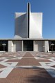 | 4 912 × 7 360 (206,9 Mio) | Fæ | LOC 2013630355, Carol M. Highsmith collection. P5279.7106 TIFF (206.9mb) |
Utilisation du fichier
La page suivante utilise ce fichier :