Fichier:Tram map of Krefeld.xcf

Fichier d’origine (1 539 × 1 175 pixels, taille du fichier : 3,65 Mio, type MIME : image/x-xcf)
Ce fichier et sa description proviennent de Wikimedia Commons.
|
Cette XCF image matricielle a été créée avec GIMP.
|
Description
| Description |
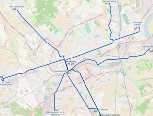
Deutsch: Topographischer Netzplan der Straßenbahn Krefeld, die normalspurige Strecke der Stadtbahn Düsseldorf ist in dunklerem Blau dargestellt.
English: Tramway network of Krefeld |
|||
| Date | ||||
| Source | openstreetmap.org | |||
| Créé par |
contributeurs d'OpenStreetMap |
|||
| Autorisation (Réutilisation de ce fichier) |
Les données d'OpenStreetMap sont disponibles sous la license Open Database (détails). Les cartes sont publiées sous license Creative Commons Attribution-Partage dans les Mêmes Conditions 2.0 (CC-BY-SA 2.0).
Ce fichier est disponible selon les termes de la licence Creative Commons Attribution – Partage dans les Mêmes Conditions 2.0 Générique
|
|||
| Géoréférencement | Si c'est inapproprié, définissez warp_status = skip pour masquer. |
Historique du fichier
Cliquer sur une date et heure pour voir le fichier tel qu'il était à ce moment-là.
| Date et heure | Vignette | Dimensions | Utilisateur | Commentaire | |
|---|---|---|---|---|---|
| actuel | 9 juin 2013 à 21:10 |  | 1 539 × 1 175 (3,65 Mio) | Bürgerentscheid | Updated to 2013-06-09. Closing of branch to Tackheide. |
| 7 avril 2013 à 14:41 |  | 1 539 × 1 175 (3,65 Mio) | Bürgerentscheid | {{XCF}} == {{int:filedesc}} == {{Information |Description=Tramway network of Krefeld |Date=2013-04-07 |Author= Bürgerentscheid |Source= Openstreetmap |Permission= |other_versions=[[File:Tram map of Krefeld.png|thumb|left|Corr... |
Utilisation du fichier
La page suivante utilise ce fichier :
Usage global du fichier
Les autres wikis suivants utilisent ce fichier :
- Utilisation sur en.wikipedia.org
- Utilisation sur fa.wikipedia.org
- Utilisation sur it.wikipedia.org
- Utilisation sur www.wikidata.org