Fichier:Riverside Raceway.JPG
Pas de plus haute résolution disponible.
Riverside_Raceway.JPG (403 × 510 pixels, taille du fichier : 326 kio, type MIME : image/jpeg)
Ce fichier et sa description proviennent de Wikimedia Commons.
Description
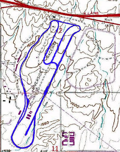
| Description | The 1969 to 1989 version of en:Riverside International Raceway in en:Riverside, California, the track diagram is in blue from using Adobe Photoshop. Image courtesy of the USGS. |
| Source | USGS and the track diagram is in blue from using Adobe Photoshop |
| Auteur | USGS and TVSRR |


Conditions d’utilisation
Cette image est placée dans le domaine public parce qu'elle contient des éléments issus de l'United States Geological Survey, une agence du Département de l'Intérieur des États-Unis. Pour plus d'information, consultez la politique officielle de copyright de l'USGS (en anglais)
|
Journal des téléversements d’origine
La page de description originale était ici. Tous les noms d'utilisateur qui suivent se rapportent à en.wikipedia.
- 2006-03-01 04:04 TVSRR 403×510×8 (333758 bytes) The 1969 to 1989 version of [[Riverside International Raceway]] in [[Riverside, California]], the track is in blue from using Adobe Photoshop. Image courtesy of the USGS
- 2005-04-10 03:34 TVSRR 740×286×8 (21712 bytes) Update of Riverside Raceway (1969 to 1989 verson). Skecth by Jason Trew
- 2005-04-10 03:17 TVSRR 740×286×8 (13359 bytes) Riverside Raceway (1969 to 1989 verson) under a rough skech through MS paint. Jason Trew sketch
Historique du fichier
Cliquer sur une date et heure pour voir le fichier tel qu'il était à ce moment-là.
| Date et heure | Vignette | Dimensions | Utilisateur | Commentaire | |
|---|---|---|---|---|---|
| actuel | 4 septembre 2007 à 11:26 | | 403 × 510 (326 kio) | Liftarn | {{Information |Description=The 1969 to 1989 version of en:Riverside International Raceway in en:Riverside, California, the track diagram is in blue from using Adobe Photoshop. Image courtesy of the USGS. |Source=Originally from [http://en.wikipe |
Utilisation du fichier
La page suivante utilise ce fichier :
Usage global du fichier
Les autres wikis suivants utilisent ce fichier :
- Utilisation sur de.wikipedia.org
- Utilisation sur en.wikipedia.org
- Moreno Valley, California
- Road racing
- Talk:Race track
- History of Riverside, California
- Riverside International Automotive Museum
- 1971 Motor Trend 500
- 1969 Motor Trend 500
- 1970 Motor Trend 500
- 1981 Winston Western 500 (November)
- 1973 Tuborg 400
- 1976 Riverside 400
- 1983 Winston Western 500
- 1981 Winston Western 500 (January)
- 1980 Warner W. Hodgdon 400
- 1985 Winston Western 500
- 1982 Winston Western 500
- 1975 Winston Western 500
- 1973 Winston Western 500
- Utilisation sur eo.wikipedia.org
- Utilisation sur es.wikipedia.org
- Utilisation sur it.wikipedia.org
- Utilisation sur ja.wikipedia.org
- Utilisation sur no.wikipedia.org