Fichier:Red kurdistan 1923 1929.png

Taille de cet aperçu : 435 × 599 pixels. Autres résolutions : 174 × 240 pixels | 349 × 480 pixels | 558 × 768 pixels | 1 205 × 1 659 pixels.
Fichier d’origine (1 205 × 1 659 pixels, taille du fichier : 396 kio, type MIME : image/png)
Ce fichier et sa description proviennent de Wikimedia Commons.
Description
| Description |
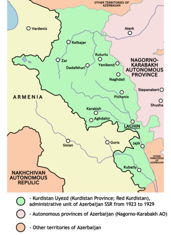
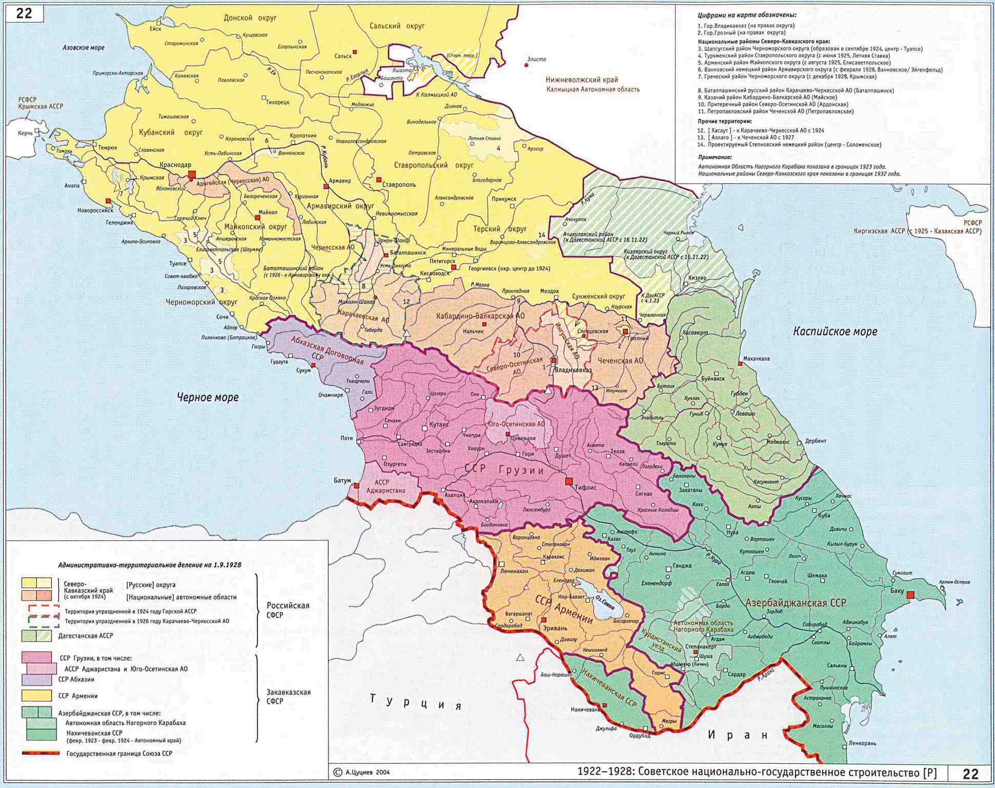
English: Map of Kurdistan uezd (Red Kurdistan) from 1923 to 1929 (borders according to the Kurdish historian Mehrdad Izady). |
| Source | Travail personnel |
| Auteur | PANONIAN |
Conditions d’utilisation
Moi, en tant que détenteur des droits d’auteur sur cette œuvre, je la publie sous la licence suivante :
| Ce fichier est disponible selon les termes de la licence Creative Commons CC0 Don universel au domaine public. | |
| La personne qui a associé une œuvre avec cet acte l’a placée dans le domaine public en renonçant mondialement à tous ses droits sur cette œuvre en vertu des lois relatives au droit d’auteur, ainsi qu’à tous les droits juridiques connexes et voisins qu’elle possédait sur l’œuvre, sans autre limite que celles imposées par la loi. Vous pouvez copier, modifier, distribuer et utiliser cette œuvre, y compris à des fins commerciales, sans qu’il soit nécessaire d’en demander la permission.
|
References
Main references - historical maps:
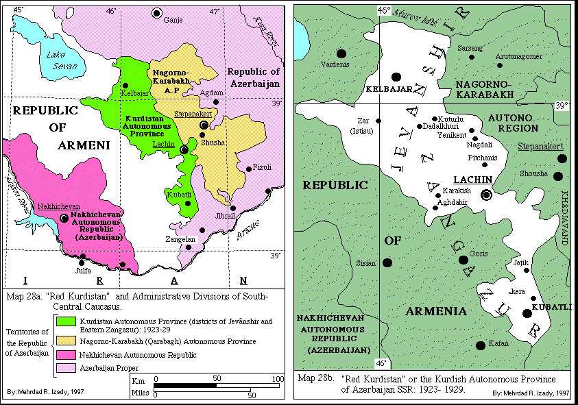
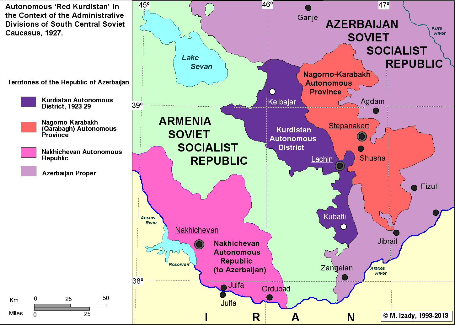
- http://www.institutkurde.org/images/cartes_and_maps/red_kurdistan.jpg (Historical map created by professor Mehrdad R. Izady, one of the most prominent native Kurdish historians. Izady finished his BA degree in History, Political Science and Geography at Kansas State University in 1976.)
- http://modersmal.skolutveckling.se/nordkurdiska/kurdmap/images/Red%20Kurdistan-and%20Administrative%20Division%20of%20Southcentral%20Caucasus_gif_gif.jpg
- http://pukmedia.co/russi/images/stories/gallery/dr-messsr/red_kurdistan.jpg
- http://www.kurdmedia.com/pix/kurdistan_map_red_main.jpg
- http://gulf2000.columbia.edu/images/maps/Caucasus_and_the_Soviet_Red_Kurdistan_lg.jpg
- http://smi2.ru/data/images/385795.jpeg
- http://www.iriston.com/books/cuciev_-_etno_atlas/maps/map22.jpg
References that mention Red Kurdistan:
- Levon Chorbajian, Patrick Donabédian, Claude Mutafian, The Caucasian knot: the history & geopolitics of Nagorno-Karabagh, Zed Books, 1994, page 140.
- Charlotte Hille, State Building and Conflict Resolution in the Caucasus, BRILL, 2010, page 200.
- Christopher J. Walker, Armenia and Karabagh: the struggle for unity, Minority Rights Group, 1991, page 114.
References that mention Kurdish Autonomous Province:
- Lokman I. Meho, The Kurds and Kurdistan: a selective and annotated bibliography, ABC-CLIO, 1997, page 17.
- David McDowall, A modern history of the Kurds, I.B.Tauris, 2000, page 492.
References that mention Kurdistan Uyezd (Русский: Курдистанский уезд):
- Территориальное и административное деление Союза ССР на 1-е января 1926 года. Народный комиссариат внутренних дел Статический Отдел. Издательства Главного Управления Коммунального Хозяйства НКВД. Москва - 1926. С. 191. (Territorial and administrative division of the USSR for 1st January 1926. Publishing house of NKVD. Page. 191) (For downloading book in 5 parts of WinDjView file СССР - январь 1926 г. )
- Central Asia and The Caucasus, Information and Analytical Center, 2003, Issues 22-24, page 75.
- United States. Foreign Broadcast Information Service, Daily report: Soviet Union, Issues 147-153, The Service, 1990, page 49.
Cette image a été promue au rang d'image de qualité d'après les critères du Guide des images.
|
Historique du fichier
Cliquer sur une date et heure pour voir le fichier tel qu'il était à ce moment-là.
| Date et heure | Vignette | Dimensions | Utilisateur | Commentaire | |
|---|---|---|---|---|---|
| actuel | 21 septembre 2021 à 19:27 | | 1 205 × 1 659 (396 kio) | Golden | fixed the borders (they were almost completely wrong); added rivers; used anti-aliasing |
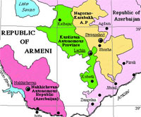
| 12 avril 2011 à 16:40 |  | 530 × 807 (58 kio) | PANONIAN | Changing main term to "Kurdistan Uyezd" to make Azeri users happy. However, two other terms (Red Kurdistan and Kurdistan Autonomous Province) should remain at least in parenthesis | |
| 9 avril 2011 à 22:18 |  | 530 × 807 (58 kio) | PANONIAN | new version, changed some descriptions per suggestions | |
| 7 avril 2011 à 17:59 |  | 530 × 807 (57 kio) | PANONIAN | {{Information |Description ={{en|1=Map of Kurdistan Autonomous Province (Red Kurdistan) from 1923 to 1929.}} |Source ={{own}} |Author =PANONIAN |Date = |Permission = |other_versions = }} |
Utilisation du fichier
Les 10 pages suivantes utilisent ce fichier :
- Kurdistan rouge
- Liste de dynasties, d'États et de divisions administratives kurdes
- Discussion:Kurdistan rouge
- Discussion:Kurdistan rouge/LSV 21861
- Utilisateur:GhosterBot/BacASable/Le saviez-vous ?/Archives
- Wikipédia:Le saviez-vous ?/Archives/2023
- Wikipédia:Statistiques des anecdotes de la page d'accueil/Visibilité des anecdotes (2023)
- Wikipédia:Statistiques des anecdotes de la page d'accueil/Visibilité des anecdotes (2023)/2023 07
- Wikipédia:Wikimag/2023/28
- Projet:Aide et accueil/Twitter/Tweets/archives/juillet 2023
Usage global du fichier
Les autres wikis suivants utilisent ce fichier :
- Utilisation sur ar.wikipedia.org
- Utilisation sur arz.wikipedia.org
- Utilisation sur azb.wikipedia.org
- Utilisation sur az.wikipedia.org
- Utilisation sur br.wikipedia.org
- Utilisation sur ckb.wikipedia.org
- Utilisation sur de.wikipedia.org
- Utilisation sur diq.wikipedia.org
- Utilisation sur en.wikipedia.org
- Utilisation sur es.wikipedia.org
- Utilisation sur fa.wikipedia.org
- Utilisation sur fi.wikipedia.org
- Utilisation sur he.wikipedia.org
- Utilisation sur it.wikipedia.org
- Utilisation sur ja.wikipedia.org
- Utilisation sur ku.wikipedia.org
- Utilisation sur pl.wikipedia.org
- Utilisation sur pt.wikipedia.org
- Utilisation sur ru.wikipedia.org
- Utilisation sur sh.wikipedia.org
- Utilisation sur sr.wikipedia.org
- Utilisation sur sv.wikipedia.org
- Utilisation sur tr.wikipedia.org
- Utilisation sur uk.wikipedia.org
- Utilisation sur www.wikidata.org
- Utilisation sur zh.wikipedia.org