Fichier:RedArmy19Aug31Dec44.jpg
Taille de cet aperçu : 788 × 600 pixels. Autres résolutions : 315 × 240 pixels | 631 × 480 pixels | 1 009 × 768 pixels | 1 256 × 956 pixels.
Fichier d’origine (1 256 × 956 pixels, taille du fichier : 531 kio, type MIME : image/jpeg)
Ce fichier et sa description proviennent de Wikimedia Commons.
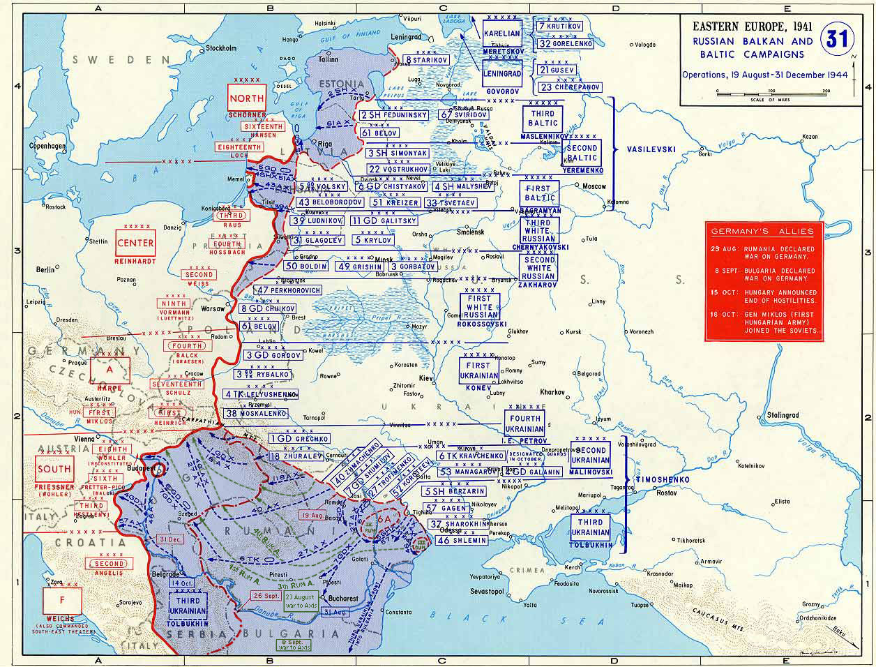
Taken from the campaign series, made public by the US-Army under www.dean.usma.edu The picture is public domain. It shows the situation of the Easter Front from 13. Aug. '44 until 31. Dec. '44
- Source: dean.usma.edu copie d'archive at the Wayback Machine
From website:
- In 1938 the predecessors of what is today The Department of History at the United States Military Academy began developing a series of campaign atlases to aid in teaching cadets a course entitled, "History of the Military Art." Since then, the Department has produced over six atlases and more than one thousand maps, encompassing not only America’s wars but global conflicts as well.
- In keeping abreast with today's technology, the Department of History is providing these maps on the internet as part of the department's outreach program. The maps were created by the United States Military Academy’s Department of History and are the digital versions from the atlases printed by the United States Defense Printing Agency. We gratefully acknowledge the accomplishments of the department's former cartographer, Mr. Edward J. Krasnoborski, along with the works of our present cartographer, Mr. Frank Martini.
- Please be aware that these maps are large in file size and may require substantial download times.
Cette image est une œuvre d'un soldat ou d'un employé de l'U.S. Army, réalisée dans le cadre de ses activités professionnelles. En tant qu'œuvre du gouvernement fédéral des États-Unis d'Amérique, cette image fait partie du domaine public.
|
 |

|
Cette image (de type carte) devrait être recréée dans un format vectoriel, en tant que fichier SVG. Cela offrirait plusieurs avantages : voir Commons:Media for cleanup pour plus d'informations. Si une version SVG de cette image est déjà disponible, merci de bien vouloir l'envoyer. Après cela, remplacez ce modèle par {{vector version available|nouveau nom d'image.svg}}.
|


Historique du fichier
Cliquer sur une date et heure pour voir le fichier tel qu'il était à ce moment-là.
| Date et heure | Vignette | Dimensions | Utilisateur | Commentaire | |
|---|---|---|---|---|---|
| actuel | 12 janvier 2015 à 20:47 | | 1 256 × 956 (531 kio) | Spiridon Ion Cepleanu | Borders of years 1940-1944 (rectified some little mistakes) |
| 22 avril 2007 à 12:52 |  | 1 256 × 956 (203 kio) | Nasiruddin | Taken from the campaign series, made public by the US-Army under www.dean.usma.edu The picture is public domain. It shows the situation of the Easter Front from 13. Aug. '44 until 31. Dec. '44 *Source: [http://www.dean.usma.edu/history/web03/atlases/grea |
Utilisation du fichier
Les 4 pages suivantes utilisent ce fichier :
Usage global du fichier
Les autres wikis suivants utilisent ce fichier :
- Utilisation sur ar.wikipedia.org
- Utilisation sur ca.wikipedia.org
- Utilisation sur cs.wikipedia.org
- Utilisation sur de.wikipedia.org
- Utilisation sur el.wikipedia.org
- Utilisation sur en.wikipedia.org
- Utilisation sur es.wikipedia.org
- Utilisation sur et.wikipedia.org
- Utilisation sur he.wikipedia.org
- Utilisation sur id.wikipedia.org
- Utilisation sur it.wikipedia.org
- Utilisation sur ja.wikipedia.org
- Utilisation sur nl.wikipedia.org
- Utilisation sur pl.wikipedia.org
- Utilisation sur pnb.wikipedia.org
- Utilisation sur ro.wikipedia.org
- Utilisation sur ru.wikipedia.org
- Utilisation sur sh.wikipedia.org
- Utilisation sur sr.wikipedia.org
- Utilisation sur tr.wikipedia.org
Voir davantage sur l’utilisation globale de ce fichier.