Fichier:Physical Map of Europe.jpg
Pas de plus haute résolution disponible.
Physical_Map_of_Europe.jpg (719 × 476 pixels, taille du fichier : 185 kio, type MIME : image/jpeg)
Ce fichier et sa description proviennent de Wikimedia Commons.
- Extended map (enlarged labels): Image:Europe_terrain_CIA_map_extended.jpg.
Description
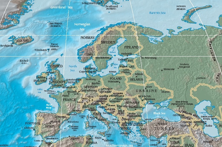
| Description | Terrain map of Europe, as cropping from the CIA's Physical Map of the World. |
| Date | Map dated April 2008 |
| Source |
Cropped section from the CIA's Physical Map of the World, formerly available at: but moved to webpage (March 2009): Those webpage URLs require secure-post ("https"), for access, because those pages are encrypted. The larger image this one was cropped from may or may not still be available. |
| Auteur | work of U.S. CIA |
| Autres versions |
Same map in expanded form (more labels):
|
Conditions d’utilisation
Cette image est dans le domaine public parce que son contenu provient du World Factbook, édité par la Central Intelligence Agency des États-Unis d’Amérique.
|
 |
Historique du fichier
Cliquer sur une date et heure pour voir le fichier tel qu'il était à ce moment-là.
| Date et heure | Vignette | Dimensions | Utilisateur | Commentaire | |
|---|---|---|---|---|---|
| actuel | 19 octobre 2005 à 13:56 | | 719 × 476 (185 kio) | Grillo | Physical map of Europe. Cropped from http://cia.gov/cia/publications/factbook/reference_maps/pdf/physical_world.pdf and converted to JPG. From en:Image:Physical Map of Europe.jpg {{PD-USGov-CIA-WF}} |
Utilisation du fichier
La page suivante utilise ce fichier :
Usage global du fichier
Les autres wikis suivants utilisent ce fichier :
- Utilisation sur as.wikipedia.org
- Utilisation sur bat-smg.wikipedia.org
- Utilisation sur bg.wiktionary.org
- Utilisation sur cy.wikipedia.org
- Utilisation sur da.wikipedia.org
- Sveriges geografi
- Norges geografi
- Danmarks geografi
- Frankrigs geografi
- Irlands geografi
- Liechtensteins geografi
- Tysklands geografi
- Østrigs geografi
- Europas geografi
- Slovakiets geografi
- Monacos geografi
- Tjekkiets geografi
- Sloveniens geografi
- Storbritanniens geografi
- Tyrkiets geografi
- Schweiz' geografi
- Skabelon:Europas geografi
- Hollands geografi
- Ukraines geografi
- Grækenlands geografi
- Utilisation sur de.wikipedia.org
- Utilisation sur el.wikipedia.org
- Utilisation sur en.wikipedia.org
- Utilisation sur es.wikipedia.org
- Utilisation sur es.wikibooks.org
- Utilisation sur id.wikipedia.org
- Utilisation sur it.wikipedia.org
- Utilisation sur ko.wikiquote.org
- Utilisation sur ky.wikipedia.org
- Utilisation sur lrc.wikipedia.org
- Utilisation sur map-bms.wikipedia.org
- Utilisation sur mk.wikipedia.org
- Utilisation sur ml.wikipedia.org
Voir davantage sur l’utilisation globale de ce fichier.