Fichier:Peters projection, date line in Bering strait.svg

Taille de cet aperçu PNG pour ce fichier SVG : 800 × 545 pixels. Autres résolutions : 320 × 218 pixels | 640 × 436 pixels | 1 024 × 697 pixels | 1 280 × 871 pixels | 2 560 × 1 743 pixels | 1 613 × 1 098 pixels.
Fichier d’origine (Fichier SVG, nominalement de 1 613 × 1 098 pixels, taille : 808 kio)
Ce fichier et sa description proviennent de Wikimedia Commons.
Description
| Description |
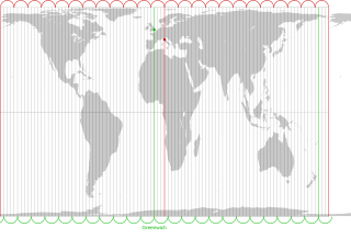
English: The Peters projection with corrected date line in the Bering strait, 168°45' West of Greenwich, proposed by Arno Peters. On his world map the easternmost part of Russia is not displayed left of Alaska, as it is usually done. Instead, it is on the right with the rest of Russia. The antipode of Peters' corrected date line is the meridian, 11° 15' East of Greenwich, traversing the city center of Florence in Italy.
The drawn out 96 meridians mark quarters of the hour. Green: Longitude of Greenwich and the old date line. Red: Longitude of Florence and Peters date line.Deutsch: Die Peters-Projektion mit korrigierter Datumsgrenze in der Beringstraße, 168°45' westlich von Greenwich. Diese wurde von Arno Peters vorgeschlagen, damit die Ostspitze Russlands auf der Weltkarte nicht wie sonst üblich abgeschnitten und links von Alaska dargestellt wird.
Die Antipode zu Peters' korrigierter Datumsgrenze ist der Meridian 11° 15' östlich von Greenwich, der durch das Stadtzentrum von Florenz in Italien verläuft. Die ausgezogenen 96 Meridiane markieren Viertelstunden. Grün: Länge von Greenwich und alte Datumsgrenze. Rot. Länge von Florenz und korrigierte Datumsgrenze in der Beringstraße. |
| Date | |
| Source | Own work by uploader. On this Peters map you can see the corrected date line |
| Auteur | Watchduck |
| Autres versions | Œuvres dérivées de ce fichier : Peters projection, blank.svg |
Conditions d’utilisation
| Moi, propriétaire des droits d’auteur sur cette œuvre, la place dans le domaine public. Ceci s'applique dans le monde entier. Dans certains pays, ceci peut ne pas être possible ; dans ce cas : J’accorde à toute personne le droit d’utiliser cette œuvre dans n’importe quel but, sans aucune condition, sauf celles requises par la loi. |
Historique du fichier
Cliquer sur une date et heure pour voir le fichier tel qu'il était à ce moment-là.
| Date et heure | Vignette | Dimensions | Utilisateur | Commentaire | |
|---|---|---|---|---|---|
| actuel | 14 mars 2009 à 00:27 | | 1 613 × 1 098 (808 kio) | Watchduck | |
| 13 mars 2009 à 19:11 |  | 1 613 × 1 098 (1,85 Mio) | Watchduck | ||
| 13 mars 2009 à 17:54 |  | 1 613 × 1 190 (1,85 Mio) | Watchduck | {{Information |Description={{en|1=The Peters projection with corrected date line in the Bering strait, 168°45' West of Greenwich, proposed by Arno Peters not to |
Utilisation du fichier
La page suivante utilise ce fichier :
Usage global du fichier
Les autres wikis suivants utilisent ce fichier :
- Utilisation sur ca.wikipedia.org
- Utilisation sur en.wikipedia.org
- Utilisation sur eo.wikipedia.org
- Utilisation sur es.wikipedia.org
- Utilisation sur fi.wikipedia.org
- Utilisation sur he.wikipedia.org
- Utilisation sur id.wikipedia.org
- Utilisation sur it.wikipedia.org
- Utilisation sur la.wikipedia.org
- Utilisation sur nds-nl.wikipedia.org
- Utilisation sur oc.wikipedia.org
- Utilisation sur pt.wikipedia.org
- Utilisation sur ru.wikipedia.org
- Utilisation sur sq.wikipedia.org
- Utilisation sur tr.wikipedia.org
- Utilisation sur zh.wikipedia.org